Epsie, Montana

Last updated
Epsie
Unincorporated community
Country United States
State Montana
County Powder River
Time zone Mountain (MST)
  Summer (DST) MDT (UTC)
Area code(s) 406

Epsie is an unincorporated community in western Powder River County, Montana, United States. It lies along U.S. Highway 212 12.7 miles (20.4 km) west of the town of Broadus, the county seat of Powder River County. [1]

Unincorporated area Region of land not governed by own local government

In law, an unincorporated area is a region of land that is not governed by a local municipal corporation; similarly an unincorporated community is a settlement that is not governed by its own local municipal corporation, but rather is administered as part of larger administrative divisions, such as a township, parish, borough, county, city, canton, state, province or country. Occasionally, municipalities dissolve or disincorporate, which may happen if they become fiscally insolvent, and services become the responsibility of a higher administration. Widespread unincorporated communities and areas are a distinguishing feature of the United States and Canada. In most other countries of the world, there are either no unincorporated areas at all, or these are very rare; typically remote, outlying, sparsely populated or uninhabited areas.

Powder River County, Montana County in the United States

Powder River County is a county in the U.S. state of Montana. As of the 2010 United States Census, the population was 1,743. Its county seat is Broadus.

Montana State of the United States of America

Montana is a landlocked state in the Northwestern United States. Montana has several nicknames, although none are official, including "Big Sky Country" and "The Treasure State", and slogans that include "Land of the Shining Mountains" and more recently "The Last Best Place".

Contents

Geography

Epsie is located in the Mountain Time Zone (MST/MDT), observes daylight saving time, lies within the 406 area code, and also in the 59346 zip code.

Climate

According to the Köppen Climate Classification system, Epsie has a semi-arid climate, abbreviated "BSk" on climate maps. [2]

Semi-arid climate climat with precipitation below potential evapotranspiration

A semi-arid climate or steppe climate is the climate of a region that receives precipitation below potential evapotranspiration, but not as low as a desert climate. There are different kinds of semi-arid climates, depending on variables such as temperature, and they give rise to different biomes.

History

In May, 1908 Epsie McAllister and her daughter Mildred traveled by train and horse from Oregon to Broadus, Montana to join her husband William. He had started the F. E. ranch in Custer County, Montana about 13 miles east of Broadus at the head of Mizpah Creek with his brothers. In 1918, when a post office was designated, it was named Epsie in honor of Epsie McAllister. In 1919, the townsite became part of the newly created Powder River County, with the town of Broadus as the county seat. The first post office operated for 19 years until 1937, then was moved a few miles north to Highway 212. Epsie had a number of buildings including a store. In 1939, Frank Peterson became the postmaster. In 1940, neighbors found him outside of his house that was on fire, with a mortal gunshot wound. The post office is now closed, and is the only standing remaining building at Epsie. [3]

Oregon State of the United States of America

Oregon is a state in the Pacific Northwest region on the West Coast of the United States. The Columbia River delineates much of Oregon's northern boundary with Washington, while the Snake River delineates much of its eastern boundary with Idaho. The parallel 42° north delineates the southern boundary with California and Nevada. Oregon is one of only four states of the continental United States to have a coastline on the Pacific Ocean.

Broadus, Montana Town in Montana, United States

Broadus is a town in and the county seat of Powder River County, Montana, United States. The population was 468 at the 2010 census.

Custer County, Montana County in the United States

Custer County is a county located in the U.S. state of Montana. As of the 2010 United States Census, the population was 11,699. Its county seat is Miles City. The county was formed in 1877 and named for George Armstrong Custer.

Related Research Articles

Hammond is an Unincorporated community in Carter County, Montana, United States with a post office. It is located about 30 miles (48 km) southeast of the town of Broadus, Montana along U.S. Highway 212. Its elevation is 3,711 feet.

Broadus Airport is a county-owned, public-use airport located three miles (5 km) northwest of the central business district of Broadus, a town in Powder River County, Montana, United States. This new airport was built at a cost of $2 million to replace the old Broadus Airport which is now closed.

Biddle, Montana census-designated place in Montana, United States

Biddle is a village in southeastern Powder River County, Montana, United States, near the Little Powder River. It lies along Highway 59, south of the town of Broadus, the county seat of Powder River County. Its elevation is 3,337 feet (1,017 m). It offers basic services not only to the community, but those that are passing through as well: a mercantile store with gas pumps, lodging through the mercantile, a post office, a one-room school accommodating grades K-8, a volunteer fire department and a small church.

Melville, Montana Unincorporated community in Montana, United States

Melville is an unincorporated community in northern Sweet Grass County, Montana, United States. It lies along local roads just west of U.S. Route 191, north of the city of Big Timber, the county seat of Sweet Grass County. Its elevation is 5,020 feet (1,530 m). Although Melville is unincorporated, it has a post office, with the ZIP code of 59055, which opened on 4 January 1883.

Cohagen, Montana Unincorporated community in Montana, United States

Cohagen is an unincorporated community in southeastern Garfield County, Montana, United States. It lies along Highway 59 southeast of the town of Jordan, the county seat of Garfield County. Its elevation is 2,720 feet (829 m). Although Cohagen is unincorporated, it has a post office, with the ZIP code of 59322, which opened on 1905-08-18.

Sanders, Montana Unincorporated community in Montana, United States

Sanders is an unincorporated community in northeastern Treasure County, Montana, United States, along the Yellowstone River. It lies along local roads east of the town of Hysham, the county seat of Treasure County. Its elevation is 2,602 feet (793 m). Sanders' post office first opened on 1904-03-30 and closed on 1905-10-14, only to be reopened on 1906-12-01. Although the post office finally closed on 1994-07-29, the community still has a separate ZIP code of 59076.

Teigen, Montana Unincorporated community in Montana, United States

Teigen was an unincorporated community in western Petroleum County, Montana, United States, stretching along Highway 200 west of the town of Winnett, the county seat of Petroleum County. Its elevation was 3,192 feet (973 m). Teigen's post office opened on November 24, 1914, and was closed on December 21, 1983,; the vicinity still has a separate ZIP code of 59084, which is serviced from Winnett

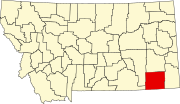
Boyes is an unincorporated village in southwestern Carter County, Montana, United States. It lies along U.S. Route 212 southwest of the town of Ekalaka, the county seat of Carter County. Its elevation is 3,330 feet (1,015 m), and it is located at 45°16′5″N105°1′52″W.

Belle Creek, Montana Unincorporated community in Montana, United States

Belle Creek is an unincorporated community in southeastern Powder River County, Montana, United States. It lies along local roads southeast of the town of Broadus, the county seat of Powder River County. Its elevation is 3,570 feet (1,088 m), and it is located at about. The town was founded in 1968 by oil and gas developer Sam Gary in response to the growth of the Bell Creek oil field.

Olive, Montana Unincorporated community in Montana, United States

Olive is an unincorporated community in north central Powder River County, Montana, United States. It lies along Highway 59 northwest of the town of Broadus, the county seat of Powder River County. Its elevation is 3,232 feet (985 m). The post office has closed.

Otter, Montana Unincorporated community in Montana, United States

Otter is an unincorporated community in southwestern Powder River County, Montana, United States, in the Custer National Forest. It lies along local roads southwest of the town of Broadus, the county seat of Powder River County. Its elevation is 3,484 feet (1,062 m). Although Otter is unincorporated, it has a post office, with the ZIP code of 59062.

Powderville, Montana Unincorporated community in Montana, United States

Powderville, also Elkhorn Crossing is an unincorporated community in northeastern Powder River County, Montana, United States, along the Powder River. It is a small cluster of buildings that lies along local roads northeast of the town of Broadus, the county seat of Powder River County. Its elevation is 2,828 feet (862 m).

Sonnette, Montana Unincorporated community in Montana, United States

Sonnette is an unincorporated community in west central Powder River County, Montana, United States. The community is situated near the headwaters of Pumpkin Creek, just west of the Custer National Forest. It lies along local roads northwest of the town of Broadus, the county seat of Powder River County. Its elevation is 3,766 feet (1,148 m).

Wyarno, Wyoming Unincorporated community in Wyoming, United States

Wyarno is an unincorporated community in central Sheridan County, Wyoming, United States. It lies along Wyoming Highway 336 about 10 miles (16 km) east of the city of Sheridan, the county seat of Sheridan County. Although Wyarno is unincorporated, it has a post office, with the ZIP code of 82845. Public education in the community of Wyarno is provided by Sheridan County School District #2.

Toyahvale, Texas Unincorporated community in Texas, United States

Toyahvale is an unincorporated community in southern Reeves County, Texas, United States. It lies along State Highway 17 and FM 3078 south of the city of Pecos, the county seat of Reeves County. Despite its similar name, Toyahvale is distinct from the town of Toyah, which lies 25 miles (40 km) to the north. Its elevation is 3,323 feet (1,013 m). Although Toyahvale is unincorporated, it has a post office, with the ZIP code of 79786.

Acton, Montana Unincorporated community in Montana, United States

Acton is an unincorporated community in northwestern Yellowstone County, Montana, United States. It has a postal ZIP code (59002) and lies along Montana Highway 3 northwest of the city of Billings, the county seat of Yellowstone County. Its elevation is 3,802 feet (1,159 m), and it is located at coordinates |45|55|50|N|108|40|51|W|

Moorhead, Montana Unincorporated community in Montana, United States

Moorhead is an unincorporated community in southern Powder River County, Montana, United States. It lies along Moorhead road about 35 miles (56 km) south of the town of Broadus, the county seat of Powder River County.

Coalwood is an unincorporated community in northern Powder River County, Montana, United States. It lies along Montana Highway 59 23.5 miles (37.8 km) north of the town of Broadus, the county seat of Powder River County.

References

  1. Rand McNally. The Road Atlas '08. Chicago: Rand McNally, 2008, p. 61.
  2. Climate Summary for Belle Creek, Montana
  3. "Epsie" . Retrieved 19 February 2015.

Coordinates: 45°29′30″N105°39′04″W / 45.49167°N 105.65111°W / 45.49167; -105.65111

Geographic coordinate system Coordinate system

A geographic coordinate system is a coordinate system that enables every location on Earth to be specified by a set of numbers, letters or symbols. The coordinates are often chosen such that one of the numbers represents a vertical position and two or three of the numbers represent a horizontal position; alternatively, a geographic position may be expressed in a combined three-dimensional Cartesian vector. A common choice of coordinates is latitude, longitude and elevation. To specify a location on a plane requires a map projection.