Powderville, Montana

Last updated

Powderville
USA Montana location map.svg
Red pog.svg
Powderville
Location within the state of Montana
Coordinates: 45°45′32″N105°6′55″W / 45.75889°N 105.11528°W / 45.75889; -105.11528
Country United States
State Montana
County Powder River
Elevation
[1]
2,828 ft (862 m)
Time zone UTC-7 (Mountain (MST))
  Summer (DST) UTC-6 (MDT)
ZIP codes
59345
GNIS feature ID775415 [1]

Powderville, also Elkhorn Crossing is an unincorporated community in northeastern Powder River County, Montana, United States, along the Powder River. It is a small cluster of buildings that lies along local roads northeast of the town of Broadus, the county seat of Powder River County. [2] Its elevation is 2,828 feet (862 m). [1]

Contents

History

Powder River Telegraph Station
near Powderville, Powder River County, Montana
Type Outpost
Site information
OwnerPrivate property
Site history
Built1878
Built byU.S. Army
MaterialsWood
Demolished1883 (decommissioned)
Garrison information
Past
commanders
Private Leopold Hohman, Private Shultz
Garrisondetachments from 5th U.S. Infantry, 2nd U.S. Cavalry

On September 7, 1865, the right and middle columns of the Powder River Expedition crossed the future site of Powderville while traveling south upriver. That evening, the columns camped several miles to the south and buried three soldiers who had died during the day.

The Powder River Telegraph Station was a U.S. Army telegraph repair station that existed from 1878 until 1883 along the Powder River in southeastern Montana Territory. Today the site is within Powder River County.

The Powder River Telegraph Repair Station was established on November 1, 1878 by soldiers of the 9th U.S. Infantry from Camp Devin on the right bank of the Powder River in southeastern Montana Territory, along the Black Hills to Fort Keogh telegraph route. Private Leopold Hohman, of Company E, 5th Infantry was assigned to the station on December 20, 1878, and given command. Privates J. Broderick and L. Smith, also of the 5th Infantry, were transferred to the outpost in early 1879 as repairmen, and the line was opened for communication in April. The opening skirmish of the Mizpah Creek Incidents, in which two U.S. Army telegraph repairmen were shot by Cheyenne warriors, took place nearby on April 5, 1879. By 1881, the outpost was "supplied with a complete set of telegraph instruments and repair tools" and maintained "66 miles of wire" between the sections of the Little Missouri Telegraph Station and that of Fort Keogh. Private Hohman left the station on April 14, 1881, and was honorably discharged that May, but he didn't leave the Powder River without leaving his mark. On a hill now called Soldiers Mount that overlooks the site of the station on the east side of the Powder River, Hohman carved his name, role, company, regiment, and the years he served the station onto a sandstone boulder that can still be read today. Hohman's rock is located about one mile east of the present-day community of Powderville. After Hohman left, Private Shultz of the 2nd Cavalry took over command of the station, and the force was decreased by one man. By the early 1880s, the route of the telegraph line became the Deadwood-Miles City stagecoach road, and in 1885 the civilian community of Powderville was built adjacent to the station. In 1885 it became a stage stop when the Deadwood to Miles City, Montana stagecoach line was established along the route of the telegraph line, crossing the Powder River at Elkhorn Crossing. The Powder River telegraph repair station was decommissioned in 1883, although U.S. Army troops from Fort Keogh continued operating in the area into the 1890s. [3]

Although Powderville is unincorporated, it had a post office with the ZIP code of 59345, from 1885 until 2011. [4]

Powderville has its own Boot Hill Cemetery. It is located on a hill overlooking the old post office.

Climate

According to the Köppen Climate Classification system, Powderville has a semi-arid climate, abbreviated "BSk" on climate maps. [5]

Climate data for Powderville, Montana, 19912020 normals, extremes 1964present
MonthJanFebMarAprMayJunJulAugSepOctNovDecYear
Record high °F (°C)68
(20)
71
(22)
84
(29)
91
(33)
102
(39)
110
(43)
110
(43)
109
(43)
105
(41)
97
(36)
79
(26)
70
(21)
110
(43)
Mean maximum °F (°C)52.5
(11.4)
56.6
(13.7)
71.6
(22.0)
80.6
(27.0)
87.8
(31.0)
95.4
(35.2)
102.0
(38.9)
100.5
(38.1)
96.3
(35.7)
83.5
(28.6)
68.4
(20.2)
54.2
(12.3)
103.5
(39.7)
Mean daily maximum °F (°C)32.4
(0.2)
36.4
(2.4)
48.5
(9.2)
59.4
(15.2)
69.5
(20.8)
79.7
(26.5)
90.0
(32.2)
89.1
(31.7)
77.6
(25.3)
60.6
(15.9)
45.7
(7.6)
34.8
(1.6)
60.3
(15.7)
Daily mean °F (°C)21.3
(−5.9)
25.1
(−3.8)
35.8
(2.1)
46.2
(7.9)
56.3
(13.5)
66.0
(18.9)
74.4
(23.6)
72.9
(22.7)
61.8
(16.6)
47.2
(8.4)
33.5
(0.8)
23.5
(−4.7)
47.0
(8.3)
Mean daily minimum °F (°C)10.1
(−12.2)
13.7
(−10.2)
23.1
(−4.9)
33.0
(0.6)
43.1
(6.2)
52.4
(11.3)
58.9
(14.9)
56.6
(13.7)
46.0
(7.8)
33.8
(1.0)
21.4
(−5.9)
12.1
(−11.1)
33.7
(0.9)
Mean minimum °F (°C)−19.1
(−28.4)
−13.9
(−25.5)
−3.5
(−19.7)
13.1
(−10.5)
25.4
(−3.7)
38.1
(3.4)
45.6
(7.6)
40.3
(4.6)
28.2
(−2.1)
12.2
(−11.0)
−3.1
(−19.5)
−14.2
(−25.7)
−27.2
(−32.9)
Record low °F (°C)−38
(−39)
−39
(−39)
−34
(−37)
−7
(−22)
12
(−11)
20
(−7)
25
(−4)
13
(−11)
11
(−12)
−13
(−25)
−28
(−33)
−45
(−43)
−45
(−43)
Average precipitation inches (mm)0.43
(11)
0.51
(13)
0.74
(19)
1.64
(42)
2.84
(72)
2.68
(68)
1.72
(44)
1.23
(31)
1.25
(32)
1.16
(29)
0.47
(12)
0.35
(8.9)
15.02
(381.9)
Average snowfall inches (cm)5.4
(14)
5.8
(15)
5.1
(13)
2.6
(6.6)
1.1
(2.8)
0.0
(0.0)
0.0
(0.0)
0.0
(0.0)
0.0
(0.0)
1.7
(4.3)
3.3
(8.4)
4.9
(12)
29.9
(76.1)
Average precipitation days (≥ 0.01 in)5.96.16.38.510.19.97.15.45.56.75.24.781.4
Average snowy days (≥ 0.1 in)4.54.23.01.50.20.00.00.00.00.82.43.620.2
Source 1: NOAA [6]
Source 2: National Weather Service [7]

See also

Related Research Articles

<span class="mw-page-title-main">Powder River County, Montana</span> County in Montana, United States

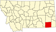
Powder River County is a county in the U.S. state of Montana. As of the 2020 census, the population was 1,694. Its county seat is Broadus.

<span class="mw-page-title-main">Mandan, North Dakota</span> Morton County Seat

Mandan is a city on the eastern border of Morton County and the eighth-most populous city in North Dakota. Founded in 1879 on the west side of the upper Missouri River, it was designated in 1881 as the county seat of Morton County. The population was 24,206 at the 2020 census. Across the Missouri River from Bismarck, Mandan is a core city of the Bismarck–Mandan Metropolitan Statistical Area.

<span class="mw-page-title-main">Alzada, Montana</span> Census-designated place in Montana, United States

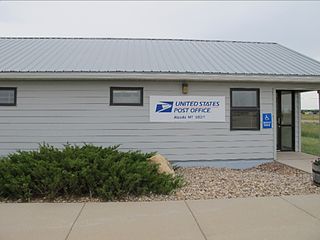
Alzada is a census-designated place in southern Carter County, Montana, United States. As of the 2010 census it had a population of 29. It is located at the intersection of U.S. Route 212 with Montana Secondary Highways 323 and 326, near the Wyoming and South Dakota borders. The Little Missouri River flows northwards to the west of the community. Alzada is in the Mountain Time Zone.

<span class="mw-page-title-main">Spotted Tail</span> Sichangu ("Brulé") Sioux chief (1823–1881)

Spotted Tail was a Sichangu Lakota tribal chief. Famed as a great warrior since his youth, warring on Ute, Pawnee and Absaroke (“Crow”), and having taken a leading part in the Grattan Massacre, he led his warriors in the Colorado and Platte River uprising after the massacre performed by John M. Chivington's Colorado Volunteers of the peaceful Cheyenne and Arapaho camping on Sand Creek, but declined to participate in Red Cloud's War.

<span class="mw-page-title-main">Fort Keogh</span> United States Army outpost in eastern Montana

Fort Keogh is a former United States Army post located at the western edge of modern Miles City, in the U.S. state of Montana. It is situated on the south bank of the Yellowstone River, at the mouth of the Tongue River.

<span class="mw-page-title-main">11th Infantry Regiment (United States)</span> Military unit

The 11th Infantry Regiment is a regiment in the United States Army. In 2007, the 11th Infantry was reflagged as the 199th Infantry Brigade, as part of the "Transformation of the US Army" effort. Today, the 11th Infantry Regiment is part of the Army's regimental system and is the primary regiment to which many Infantry School units are aligned.

<span class="mw-page-title-main">Department of the Platte</span> Military unit

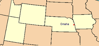
The Department of the Platte was a military administrative district established by the U.S. Army on March 5, 1866, with boundaries encompassing Iowa, Nebraska, Dakota Territory, Utah Territory and a small portion of Idaho. With headquarters in Omaha, the district commander oversaw the army's role initially along the Overland route to Salt Lake City, then later the construction route of the Union Pacific Railroad. The district also included the Montana road through eastern Wyoming. The district was discontinued when the Army's command was reorganized in 1898.

<span class="mw-page-title-main">Gustavus Cheyney Doane</span> US Army officer and explorer (1840–1892)

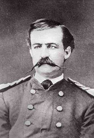
Gustavus Cheyney Doane was a U.S. Army Cavalry Captain, explorer, inventor and Civil War soldier who played a prominent role in the exploration of Yellowstone as a member of the Washburn–Langford–Doane Expedition. Doane was a participant in the Marias Massacre of approximately 200 Piegan Blackfeet people.

<span class="mw-page-title-main">Northern Cheyenne Exodus</span> Attempt of the Northern Cheyenne to return to the north

The Northern Cheyenne Exodus, also known as Dull Knife's Raid, the Cheyenne War, or the Cheyenne Campaign, was the attempt of the Northern Cheyenne to return to the north, after being placed on the Southern Cheyenne reservation in the Indian Territory, and the United States Army operations to stop them. The period lasted from 1878 to 1879.

<span class="mw-page-title-main">Fort Meade (South Dakota)</span> Military base in South Dakota, United States

Fort Meade is a former United States Army post located just east of Sturgis, South Dakota. The fort was active from 1878 to 1944; the cantonment is currently home to a Veterans Health Administration hospital and South Dakota Army National Guard training facilities. Much of the former reservation is now managed by the Bureau of Land Management as the Fort Meade Recreation Area. It is also home of Fort Meade National Cemetery. Fort Meade was established in 1878 to protect illegal white settlements on the Great Sioux Reservation in the northern Black Hills, especially the nearby gold mining area around Deadwood. Several stage and freighting routes passed through Fort Meade en route to Deadwood.

<span class="mw-page-title-main">Camp Poplar River</span>

Camp Poplar River was established during the Indian wars in the Department of Dakota by U.S. Army to maintain order, keep non-agency Indians away, and help capture the Indians who disturbed the peace and would not conform to reservation boundaries of the Fort Peck Agency, which in 1878, was relocated to its present-day location in Poplar because the original agency was located on a flood plain, suffering floods each spring. The post was located one-half mile north of the then called, Poplar River Agency, or 2 miles north of the Missouri River on the south bank of the Poplar River and normally consisted of only two companies of infantry. This tiny post has disappeared except for the fact that the town of Poplar, Montana, on the site, bears the same name.

<span class="mw-page-title-main">Fort McKinney (Wyoming)</span> United States historic place

Fort McKinney (1877–1894) was a military post located in North Eastern Wyoming, near the Powder River.

<span class="mw-page-title-main">Powder River Station-Powder River Crossing</span> United States historic place

The Powder River Crossing, officially known as Powder River Station-Powder River Crossing , is an abandoned settlement located on the east bank of the Powder River in southeast Johnson County about twenty-four miles east of Kaycee, Wyoming. It developed after a wooden toll bridge was built across the Powder River in 1877, at a site that was originally used as a ford. With crossing secured, a settlement developed here in the late 19th century, incorporating a stage stop on the Bozeman Trail. The site is notable for having well-preserved wagon ruts from the pioneer era.

<span class="mw-page-title-main">Crazy Woman Crossing</span> United States historic place

Crazy Woman Crossing is a historic place on the Bozeman Trail, in Johnson County, Wyoming, United States, about twenty miles southeast of Buffalo. Crazy Woman Crossing was one of three major fords used by travelers across creeks and rivers in this area. It is significant as the site of the Battle of Crazy Woman, a skirmish during Red Cloud's War in 1866. The United States pulled out of this territory after negotiation with the Lakota and allies of the Treaty of Fort Laramie of 1868.

The Battle of Platte Bridge, also called the Battle of Platte Bridge Station, on July 26, 1865, was the culmination of a summer offensive by the Lakota Sioux and Cheyenne Indians against the United States army. In May and June the Indians raided army outposts and stagecoach stations over a wide swath of Wyoming and Montana. In July, they assembled a large army, estimated by Cheyenne warrior George Bent to number 3,000 warriors, and descended upon Platte Bridge. The bridge, across the North Platte River near present-day Casper, Wyoming, was guarded by 120 soldiers. In an engagement near the bridge, and another against a wagon train guarded by 28 soldiers a few miles away, the Indians killed 29 soldiers while suffering at least eight dead.

Rochford is an unincorporated community in Pennington County, South Dakota, United States. It is not tracked by the U.S. Census Bureau.

The Battle of Pumpkin Creek, also known as the Volborg fight, was fought February 7–8, 1880, by United States Soldiers, and Scouts, against Sioux warriors. The Battle occurred near Pumpkin Creek, a tributary of Tongue River, in Montana Territory, in present-day Montana, United States.

The Mizpah Creek incidents, were a series of incidents that occurred from April 5 – June 8, 1879, between United States soldiers and civilians, and eight Northern Cheyennes, that resulted in the death of one U.S. soldier, and the capture of the eight Cheyenne, three of whom committed suicide in prison at Miles City, Montana Territory. The incidents occurred near Mizpah Creek, a tributary of the Powder River, in Montana Territory.

Camp Devin was a temporary United States Army camp established on June 30, 1878 during the building of the Fort Keogh-Deadwood Telegraph Line. It was named for Brevet Major General Thomas C. Devin, and abandoned in late 1878.

Fort Maginnis was established during the Indian wars in the Department of Dakota by the U.S. Army. It was the last of five forts: Keogh (1876), Custer (1877), Missoula (1877), Assinniboine (1879), and Maginnis (1880) - built following the defeat of Lieutenant Colonel George A. Custer by Native Americans at the Battle of Little Bighorn in June, 1876.
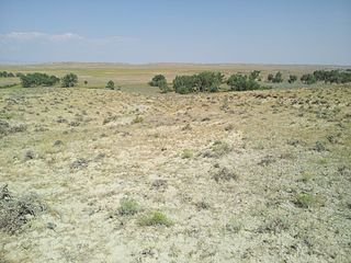
References

  1. 1 2 3 U.S. Geological Survey Geographic Names Information System: Powderville, Montana
  2. Rand McNally. The Road Atlas '08. Chicago: Rand McNally, 2008, p. 61.
  3. "Annual Report of the Chief Signal Officer of the Army to the Secretary of War". United States Army Signal Corps, 1879. 1881. Retrieved December 3, 2017.
  4. Zip Code Lookup
  5. Climate Summary for Powderville, Montana
  6. "U.S. Climate Normals Quick Access". National Oceanic and Atmospheric Administration. Retrieved August 7, 2022.
  7. "NOAA Online Weather Data". National Weather Service. Retrieved August 7, 2022.