Powdersville, South Carolina

Last updated

Powdersville
CDP
PowdersvilleSCMon.png
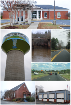
Top, left to right: Powdersville Branch Library, water tower, Saluda River, Powdersville Main, Highway 153, Bethesda Church, Powdersville Volunteer Fire Department
USA South Carolina location map.svg
Red pog.svg
Powdersville
Location within the state of South Carolina
Coordinates: 34°46′57″N82°29′32″W / 34.78250°N 82.49222°W / 34.78250; -82.49222
Country United States
State South Carolina
County Anderson
Area
[1]
  Total13.88 sq mi (35.94 km2)
  Land13.76 sq mi (35.63 km2)
  Water0.12 sq mi (0.30 km2)
Elevation
[2]
968 ft (295 m)
Population
 (2020) [3]
  Total10,025
  Density728.67/sq mi (281.34/km2)
Time zone UTC-5 (Eastern (EST))
  Summer (DST) UTC-4 (EDT)
FIPS code 45-58165 [4]
GNIS feature ID1250233 [2]

Powdersville is a census-designated place (CDP) in Anderson County, South Carolina. The population was 10,025 at the 2020 census,. [5]

Contents

History

The name Powders comes from the production and trade of gunpowder in the area. One of the first stores in present-day Powdersville was called the Powdersville Area General Store. In 1859 a powder mill was established in present-day Powdersville by John Bowen. During the American Civil War, the area was used to store gunpowder though Columbia remained the primary production site of the state's powder. Due to the area's use of gunpowder, the name Powders became a fixture for the location. [6] The Saluda Valley-Powdersville Water Company was created in 1971 to serve drinking water to around 1,200 customers. In 1992, the name changed to Powdersville Water Company and in 2001 the name changed again to Powdersville Water District. [7] [8] The first high school in Powdersville was established in 2011 as Powdersville High School. [9]

Geography

Powdersville is located in the northern corner of Anderson County at 34°46′57″N82°29′32″W / 34.78250°N 82.49222°W / 34.78250; -82.49222 (34.782620, -82.492138). [10] Its northwest border is the Pickens County line, and its northeast border is the Saluda River, which forms the Greenville County line. The southeast border of the CDP is formed by Interstate 85, a six-lane highway with access to Powdersville via exits 39 and 40. Greenville, the largest city in the region, is 8 miles (13 km) to the northeast.

According to the United States Census Bureau, the CDP has a total area of 14.0 square miles (36.3 km2), of which 13.9 square miles (35.9 km2) is land and 0.12 square miles (0.3 km2), or 0.90%, is water.

Demographics

Historical population
CensusPop.Note
2000 5,362
2010 7,61842.1%
2020 10,02531.6%
U.S. Decennial Census [11]
Powdersville town sign PowdersvilleSCSign.jpg
Powdersville town sign

2020 census

Powdersville racial composition [12]
RaceNum.Perc.
White (non-Hispanic)7,51574.96%
Black or African American (non-Hispanic)9269.24%
Native American 140.14%
Asian 5085.07%
Pacific Islander 60.06%
Other/Mixed 4064.05%
Hispanic or Latino 6506.48%

As of the 2020 United States census, there were 10,025 people, 3,515 households, and 2,570 families residing in the CDP.

2000 census

As of the census [4] of 2000, there were 5,362 people, 1,989 households, and 1,615 families residing in the CDP. The population density was 384.4 inhabitants per square mile (148.4/km2). There were 2,133 housing units at an average density of 152.9 per square mile (59.0/km2). The racial makeup of the CDP was 94.18% White, 4.35% African American, 0.26% Native American, 0.37% Asian, 0.06% Pacific Islander, 0.21% from other races, and 0.58% from two or more races. Hispanic or Latino of any race were 1.14% of the population.

There were 1,989 households, out of which 37.4% had children under the age of 18 living with them, 69.8% were married couples living together, 8.2% had a female householder with no husband present, and 18.8% were non-families. 16.9% of all households were made up of individuals, and 5.6% had someone living alone who was 65 years of age or older. The average household size was 2.70 and the average family size was 3.01.

In the CDP, the population was spread out, with 26.0% under the age of 18, 7.0% from 18 to 24, 30.4% from 25 to 44, 27.2% from 45 to 64, and 9.4% who were 65 years of age or older. The median age was 38 years. For every 100 females, there were 95.8 males. For every 100 females age 18 and over, there were 96.1 males.

The median income for a household in the CDP was $50,255, and the median income for a family was $57,131. Males had a median income of $41,297 versus $25,136 for females. The per capita income for the CDP was $20,901. About 2.4% of families and 2.5% of the population were below the poverty line, including 1.1% of those under age 18 and 7.3% of those age 65 or over.
Religion

The largest religious group in Powdersville is Protestant. The oldest church congregation in Powdersville dating back to 1833 is Bethesda Church.

Education

Powdersville High School PowdersvilleHS.jpg
Powdersville High School

Public education in Powdersville is administered by Anderson County School District One. The district operates Concrete Primary School, Powdersville Elementary School, Powdersville Middle School and Powdersville High School.

Powdersville has a public library, a branch of the Anderson County Library System. [13]

Transportation

State Highways

Interstate

Related Research Articles

<span class="mw-page-title-main">Saluda County, South Carolina</span> County in South Carolina, United States

Saluda County is a county in the U.S. state of South Carolina. As of the 2020 census, the population was 18,862. Its county seat is Saluda. The county was formed from northern and eastern portions of Edgefield County.

<span class="mw-page-title-main">Anderson County, South Carolina</span> County in South Carolina, United States

Anderson County is a county located in the U.S. state of South Carolina. As of the 2020 census, its population was 203,718. Its county seat is Anderson. Named for Revolutionary War leader Robert Anderson, the county is located in northwestern South Carolina, along the state line of Georgia. Anderson County is included in the Greenville-Anderson-Greer, SC Metropolitan Statistical Area. Anderson County contains 55,950-acre (22,640 ha) Lake Hartwell, a U.S. Army Corps of Engineers lake with nearly 1,000 miles (1,600 km) of shoreline for residential and recreational use. The area is a growing industrial, commercial and tourist center. It is the home of Anderson University, a private, selective comprehensive university of approximately 4,000 undergraduate and graduate students.

<span class="mw-page-title-main">Palermo, California</span> Census-designated place in California, United States

Palermo is a census-designated place (CDP) in Butte County, California, United States. The population was 5,382 at the 2010 census, down from 5,720 at the 2000 census.

<span class="mw-page-title-main">Hazardville, Connecticut</span> Census-designated place in Connecticut, United States

Hazardville is a section of the town of Enfield, Connecticut, United States, in Hartford County. It is a census-designated place (CDP) that had a total population of 4,599 as of the 2010 census.

<span class="mw-page-title-main">Gardnertown, New York</span> Census-designated place in New York, United States

Gardnertown is a hamlet in Orange County, New York, United States. The population was 4,542 at the 2020 census. It is part of the Poughkeepsie–Newburgh–Middletown, NY Metropolitan Statistical Area as well as the larger New York–Newark–Bridgeport, NY-NJ-CT-PA Combined Statistical Area.

<span class="mw-page-title-main">East Flat Rock, North Carolina</span> Census-designated place in North Carolina, United States

East Flat Rock is an unincorporated area and census-designated place (CDP) in Henderson County, North Carolina, United States. The population was 4,995 at the 2010 census, up from 4,151 at the 2000 census. It is part of the Asheville Metropolitan Statistical Area.

<span class="mw-page-title-main">Centerville, South Carolina</span> CDP in South Carolina, United States

Centerville is a census-designated place (CDP) in Anderson County, South Carolina. The population was 7,185 at the 2020 census.

<span class="mw-page-title-main">Pelzer, South Carolina</span> Town in South Carolina, United States

Pelzer is a town in Anderson County, South Carolina, United States, along the Saluda River. The population was 89 at the 2010 census, and grew to 1,344 at the 2020 census.

<span class="mw-page-title-main">Williamston, South Carolina</span> Town in South Carolina, United States

Williamston is a town in Anderson County, South Carolina. The population was 4,043 at the 2020 census.

<span class="mw-page-title-main">Golden Grove, South Carolina</span> Census-designated place in South Carolina, United States

Golden Grove is a census-designated place (CDP) in Greenville County, South Carolina, United States. The population was 2,467 at the 2010 census. It is part of the Greenville–Mauldin–Easley Metropolitan Statistical Area.

Parker is a census-designated place (CDP) in Greenville County, South Carolina, United States. The population was 11,431 at the 2010 census, up from 10,760 in 2000. It is part of the Greenville–Mauldin–Easley Metropolitan Statistical Area.

<span class="mw-page-title-main">Slater-Marietta, South Carolina</span> Census-designated place in South Carolina, United States

Slater-Marietta is a census-designated place (CDP) in Greenville County, South Carolina, United States, along the North Saluda River. At the 2000 census, there were 2,228 people. At the 2010 census, there were 2,176. At the 2020 census, there were 1,873. It is part of the Greenville–Mauldin–Easley Metropolitan Statistical Area.

<span class="mw-page-title-main">Welcome, South Carolina</span> Census-designated place in South Carolina, United States

Welcome is a census-designated place (CDP) in Greenville County, South Carolina, United States. The population was 6,668 at the 2010 census. It is part of the Greenville–Mauldin–Easley Metropolitan Statistical Area. Welcome has been noted for its colorful place name.

<span class="mw-page-title-main">Mountville, South Carolina</span> Census-designated place in South Carolina, United States

Mountville is an unincorporated community and census-designated place (CDP) in Laurens County, South Carolina, United States. The population was 108 at the 2010 census, down from 130 at the 2000 census. It is part of the Greenville–Mauldin–Easley Metropolitan Statistical Area.

Seven Oaks is a census-designated place (CDP) in Lexington County, South Carolina, United States, 8 miles (13 km) northwest of downtown Columbia, the state capital. The population of the CDP was 15,144 at the 2010 census. It is part of the Columbia Metropolitan Statistical Area.

<span class="mw-page-title-main">Saluda, South Carolina</span> Town in South Carolina, United States

Saluda is a town in Saluda County, South Carolina, United States, along the Little Saluda River. The population was 3,565 at the 2010 census. It is the county seat of Saluda County.

<span class="mw-page-title-main">Boiling Springs, South Carolina</span> CDP in South Carolina, United States

Boiling Springs is a census-designated place (CDP) in Spartanburg County, South Carolina, United States. The population was 8,219 at the 2010 census.

Stateburg is a census-designated place (CDP) in the High Hills of Santee in Sumter County, South Carolina, United States. The population was 1,380 at the 2010 census. It is included in the Sumter, South Carolina Metropolitan Statistical Area. Stateburg is located within the larger Stateburg Historic District.

<span class="mw-page-title-main">Lake Wylie, South Carolina</span> CDP in South Carolina, United States

Lake Wylie is a census-designated place (CDP) in York County, South Carolina, United States. The population was 8,841 at the 2010 census. Lake Wylie is located on a peninsula along the shore of Lake Wylie, a reservoir that was named for Dr. W. Gil Wylie in 1960. It is a suburb of Charlotte, North Carolina.

<span class="mw-page-title-main">Piedmont, South Carolina</span> CDP in South Carolina, United States

Piedmont is a census-designated place (CDP) along the Saluda River in Anderson and Greenville counties in the U.S. state of South Carolina. The population was 5,411 at the 2020 census.

References

  1. "ArcGIS REST Services Directory". United States Census Bureau. Retrieved October 15, 2022.
  2. 1 2 U.S. Geological Survey Geographic Names Information System: Powdersville, South Carolina
  3. "Census Population API". United States Census Bureau. Retrieved October 15, 2022.
  4. 1 2 "U.S. Census website". United States Census Bureau . Retrieved January 31, 2008.
  5. "Geographic Identifiers: 2010 Demographic Profile Data (G001): Powdersville CDP, South Carolina". U.S. Census Bureau, American Factfinder. Archived from the original on February 12, 2020. Retrieved August 8, 2013.
  6. Poole, W. Scott (2005). South Carolina's Civil War: A Narrative History. Mercer University Press. p. 53.
  7. "About Powdersville". Powdersville.com.
  8. "History of the Powdersville Water District". powdersvillewaterdistrict.com.
  9. "Superintendent's Overview" (PDF). schoolwires.com.
  10. "US Gazetteer files: 2010, 2000, and 1990". United States Census Bureau. February 12, 2011. Retrieved April 23, 2011.
  11. "Census of Population and Housing". Census.gov. Retrieved June 4, 2016.
  12. "Explore Census Data". data.census.gov. Retrieved December 14, 2021.
  13. "South Carolina libraries and archives". SCIWAY. Retrieved June 7, 2019.