Piedmont, South Carolina

Last updated

Piedmont
CDP
PiedmontSCMon.png
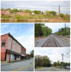
Top, left to right: Ruins of the Piedmont Number One overlooking the Saluda River, Main Street, Railroad, Piedmont Highway
SCMap-doton-Piedmont.PNG
Location of Piedmont, South Carolina
Coordinates: 34°42′15″N82°27′41″W / 34.70417°N 82.46139°W / 34.70417; -82.46139
Country United States
State South Carolina
Counties Anderson, Greenville
Area
[1]
  Total8.78 sq mi (22.73 km2)
  Land8.60 sq mi (22.26 km2)
  Water0.18 sq mi (0.46 km2)
Elevation
[2]
791 ft (241 m)
Population
 (2020) [3]
  Total5,411
  Density629.48/sq mi (243.04/km2)
Time zone UTC-5 (Eastern (EST))
  Summer (DST) UTC-4 (EDT)
ZIP code
29673
Area code 864
FIPS code 45-56365 [4]
GNIS feature ID1225406 [2]

Piedmont is a census-designated place (CDP) along the Saluda River in Anderson and Greenville counties in the U.S. state of South Carolina. The population was 5,411 at the 2020 census. [5]

Contents

Piedmont is a part of the Greenville-Anderson metropolitan area.

History

Downtown Piedmont around 1890 PiedmontSC1890.jpg
Downtown Piedmont around 1890

Native Americans and early settlers of Piedmont called the area "Big Shoals of the Saluda" after the Saluda River. The Native Americans used the shoals as a crossing. David Garrison established a grist mill around 1850 upon the shoals changing the name of the area to Garrison Shoals. Henry Pinckney Hammett bought this property for his cotton mill that used water power of the shoals. The name of the area changed again to Piedmont, "foot of the Mountains" and became a mill town. The American Civil War disrupted Hammett's project until 1876 when his plant began operations. Piedmont was added to Hammett's charter for Piedmont Manufacturing Company and a railroad station. Water power from the Saluda River was also used to produce electricity to run the machinery from the 1880s to the 1920s. The machinery of the Piedmont Manufacturing Company was from Saco Lowell and Whitin Machine Works that helped finance Hammett's company. [6] In 1946 the mills were sold to J.P. Stevens and Company where it then was updated with modern features. Manufacturing continued until 1977 and in 1983 most of Piedmont Manufacturing Company burned down. [7]

Geography

Piedmont is located in northern Anderson County and southwestern Greenville County at 34°42′15″N82°27′41″W / 34.70417°N 82.46139°W / 34.70417; -82.46139 (34.704140, -82.461427). [8] It is 12 miles (19 km) south of the center of Greenville. Exit 35 on Interstate 85 is 2 miles (3 km) to the west of the center of Piedmont. South Carolina state road 86 cuts through the small town also, connecting with Interstate 85 at Exit 35. According to the United States Census Bureau, the CDP has a total area of 8.8 square miles (22.7 km2), of which 8.6 square miles (22.3 km2) is land and 0.15 square miles (0.4 km2), or 1.93%, is water. [5] The Saluda River flows southwards over a dam through the center of town.

Demographics

Historical population
CensusPop.Note
2000 4,684
2010 5,1038.9%
2020 5,4116.0%
U.S. Decennial Census [9]

2020 census

Piedmont racial composition [10]
RaceNum.Perc.
White (non-Hispanic)4,32179.86%
Black or African American (non-Hispanic)5089.39%
Native American 100.18%
Asian 160.3%
Other/Mixed 2875.3%
Hispanic or Latino 2694.97%

As of the 2020 United States census, there were 5,411 people, 1,787 households, and 1,476 families residing in the CDP.

2000 census

As of the census [4] of 2000, there were 4,684 people, 1,829 households, and 1,349 families residing in the CDP. The population density was 545.6 inhabitants per square mile (210.7/km2). There were 1,992 housing units at an average density of 232.0 per square mile (89.6/km2). The racial makeup of the CDP was 92.08% White, 5.85% African American, 0.19% Native American, 0.23% Asian, 0.02% Pacific Islander, 0.11% from other races, and 1.52% from two or more races. Hispanic or Latino of any race were 1.20% of the population.

There were 1,829 households, out of which 32.9% had children under the age of 18 living with them, 57.4% were married couples living together, 12.4% had a female householder with no husband present, and 26.2% were non-families. 23.1% of all households were made up of individuals, and 9.6% had someone living alone who was 65 years of age or older. The average household size was 2.52 and the average family size was 2.95.

In the CDP, the population was spread out, with 24.9% under the age of 18, 7.7% from 18 to 24, 29.7% from 25 to 44, 23.9% from 45 to 64, and 13.9% who were 65 years of age or older. The median age was 37 years. For every 100 females, there were 90.8 males. For every 100 females age 18 and over, there were 85.8 males.

The median income for a household in the CDP was $36,310, and the median income for a family was $41,654. Males had a median income of $34,890 versus $23,250 for females. The per capita income for the CDP was $16,982. About 7.9% of families and 10.5% of the population were below the poverty line, including 11.6% of those under age 18 and 15.8% of those age 65 or over.

Education

Schools in Piedmont include Wren High School, Wren Middle School, Wren Elementary School, Spearman Elementary School all located in Anderson School District One, and Woodmont High School, Woodmont Middle School, and Sue Cleveland Elementary School all located in the Greenville County School District.

Piedmont has a public library, a branch of the Anderson County Library System. [11]

Notable people

Related Research Articles

<span class="mw-page-title-main">Laurens County, South Carolina</span> County in South Carolina, United States

Laurens County is a county located in the U.S. state of South Carolina. As of the 2020 census, its population was 67,539. Its county seat is Laurens.

<span class="mw-page-title-main">Greenwood County, South Carolina</span> County in South Carolina, United States

Greenwood County is a county located in the U.S. state of South Carolina. As of the 2020 census, its population was 69,351. Its county seat is Greenwood.

<span class="mw-page-title-main">Anderson County, South Carolina</span> County in South Carolina, United States

Anderson County is a county located in the U.S. state of South Carolina. As of the 2020 census, its population was 203,718. Its county seat is Anderson. Named for Revolutionary War leader Robert Anderson, the county is located in northwestern South Carolina, along the state line of Georgia. Anderson County is included in the Greenville-Anderson-Greer, SC Metropolitan Statistical Area. Anderson County contains 55,950-acre (22,640 ha) Lake Hartwell, a U.S. Army Corps of Engineers lake with nearly 1,000 miles (1,600 km) of shoreline for residential and recreational use. The area is a growing industrial, commercial and tourist center. It is the home of Anderson University, a private, selective comprehensive university of approximately 4,000 undergraduate and graduate students.

<span class="mw-page-title-main">Belton, South Carolina</span> City in South Carolina, United States

Belton is a city in eastern Anderson County, South Carolina. The population was 4,134 at the 2010 census.

<span class="mw-page-title-main">Pelzer, South Carolina</span> Town in South Carolina, United States

Pelzer is a town in Anderson County, South Carolina, United States, along the Saluda River. The population was 89 at the 2010 census, and grew to 1,344 at the 2020 census.

<span class="mw-page-title-main">Powdersville, South Carolina</span> CDP in South Carolina, United States

Powdersville is a census-designated place (CDP) in Anderson County, South Carolina. The population was 10,025 at the 2020 census,.

<span class="mw-page-title-main">West Pelzer, South Carolina</span> Town in South Carolina, United States

West Pelzer is a town in Anderson County, South Carolina. The population was 962 at the 2020 census.

<span class="mw-page-title-main">Williamston, South Carolina</span> Town in South Carolina, United States

Williamston is a town in Anderson County, South Carolina. The population was 4,043 at the 2020 census.

Five Forks is a census-designated place (CDP) in Greenville County, South Carolina, United States. The population was 17,737 at the 2020 census, up from 14,140 in 2010, and 8,064 in 2000. It is a growing, affluent suburb of Greenville and is part of the Greenville–Mauldin–Easley Metropolitan Statistical Area.

<span class="mw-page-title-main">Golden Grove, South Carolina</span> Census-designated place in South Carolina, United States

Golden Grove is a census-designated place (CDP) in Greenville County, South Carolina, United States. The population was 2,467 at the 2010 census. It is part of the Greenville–Mauldin–Easley Metropolitan Statistical Area.

Parker is a census-designated place (CDP) in Greenville County, South Carolina, United States. The population was 11,431 at the 2010 census, up from 10,760 in 2000. It is part of the Greenville–Mauldin–Easley Metropolitan Statistical Area.

<span class="mw-page-title-main">Slater-Marietta, South Carolina</span> Census-designated place in South Carolina, United States

Slater-Marietta is a census-designated place (CDP) in Greenville County, South Carolina, United States, along the North Saluda River. At the 2000 census, there were 2,228 people. At the 2010 census, there were 2,176. At the 2020 census, there were 1,873. It is part of the Greenville–Mauldin–Easley Metropolitan Statistical Area.

Wade Hampton is a census-designated place (CDP) in Greenville County, South Carolina, United States. The population was 20,622 at the 2010 census. It is named for American Civil War general and South Carolina governor Wade Hampton.

<span class="mw-page-title-main">Welcome, South Carolina</span> Census-designated place in South Carolina, United States

Welcome is a census-designated place (CDP) in Greenville County, South Carolina, United States. The population was 6,668 at the 2010 census. It is part of the Greenville–Mauldin–Easley Metropolitan Statistical Area. Welcome has been noted for its colorful place name.

<span class="mw-page-title-main">Joanna, South Carolina</span> Census-designated place in South Carolina, United States

Joanna is an unincorporated community and census-designated place (CDP) in Laurens County, South Carolina, United States. The population was 1,539 at the 2010 census, down from 1,609 at the 2000 census. It is part of the Greenville–Mauldin–Easley Metropolitan Statistical Area.

<span class="mw-page-title-main">Mountville, South Carolina</span> Census-designated place in South Carolina, United States

Mountville is an unincorporated community and census-designated place (CDP) in Laurens County, South Carolina, United States. The population was 108 at the 2010 census, down from 130 at the 2000 census. It is part of the Greenville–Mauldin–Easley Metropolitan Statistical Area.

<span class="mw-page-title-main">Watts Mills, South Carolina</span> Census-designated place in South Carolina, United States

Wattsville is an unincorporated community in Laurens County, South Carolina, United States. The town name is derived from Watts Mill, a textile mill in the center of town. The area is listed as the Wattsville census-designated place (CDP) for statistical purposes. The population of the CDP was 1,635 at the 2010 census. It is part of the Greenville–Mauldin–Easley Metropolitan Statistical Area.

<span class="mw-page-title-main">Pickens, South Carolina</span> City in South Carolina, United States

Pickens, formerly called Pickens Courthouse, is a city in and the county seat of Pickens County, South Carolina, United States. The population was 3,126 at the 2010 census. Pickens changed its classification from a town to a city in 1998, but it was not reported to the Census Bureau until 2001. It was named after Andrew Pickens (1739–1817), an American revolutionary soldier and US Congressman for South Carolina.

<span class="mw-page-title-main">Honea Path, South Carolina</span> Town in South Carolina, United States

Honea Path is a town primarily in Anderson County, South Carolina and extending into Abbeville County in the northwest part of the state. The population was 3,686 at the 2020 census.

<span class="mw-page-title-main">Ware Shoals, South Carolina</span> Town in South Carolina, United States

Ware Shoals is a town in Abbeville, Greenwood, and Laurens counties in the U.S. state of South Carolina, along the Saluda River. Ware Shoals has a population of 1,607 according to the 2020 United States Census.

References

  1. "ArcGIS REST Services Directory". United States Census Bureau. Retrieved October 15, 2022.
  2. 1 2 U.S. Geological Survey Geographic Names Information System: Piedmont, South Carolina
  3. "Census Population API". United States Census Bureau. Retrieved October 15, 2022.
  4. 1 2 "U.S. Census website". United States Census Bureau . Retrieved January 31, 2008.
  5. 1 2 "Geographic Identifiers: 2010 Demographic Profile Data (G001): Piedmont CDP, South Carolina". U.S. Census Bureau, American Factfinder. Archived from the original on February 12, 2020. Retrieved August 8, 2013.
  6. "History". Greenville Textile Heritage Society. Retrieved January 11, 2016.
  7. "Piedmont Mill". sciway.net. SCIWAY. Retrieved January 11, 2016.
  8. "US Gazetteer files: 2010, 2000, and 1990". United States Census Bureau. February 12, 2011. Retrieved April 23, 2011.
  9. "Census of Population and Housing". Census.gov. Retrieved June 4, 2016.
  10. "Explore Census Data". data.census.gov. Retrieved December 14, 2021.
  11. "South Carolina libraries and archives". SCIWAY. Retrieved June 7, 2019.
  12. "The Birth of a Nation". TCM. TCM. Retrieved January 11, 2016.