Related Research Articles

The Great Sandy Desert is an interim Australian bioregion, located in the northeast of Western Australia straddling the Pilbara and southern Kimberley regions and extending east into the Northern Territory. It is the second largest desert in Australia after the Great Victoria Desert and encompasses an area of 284,993 square kilometres (110,036 sq mi). The Gibson Desert lies to the south and the Tanami Desert lies to the east of the Great Sandy Desert.

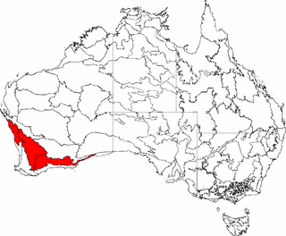
Southwest Australia is a biogeographic region in Western Australia. It includes the Mediterranean-climate area of southwestern Australia, which is home to a diverse and distinctive flora and fauna.

The Murchison is a loosely defined area of Western Australia located within the interior of the Mid West region. It was the subject of a major gold rush in the 1890s and remains a significant mining district. The Murchison is also included as an interim Australian bioregion. The bioregion is loosely related to the catchment area of the Murchison River and has an area of 281,205 square kilometres (108,574 sq mi).

The Swan Coastal Plain in Western Australia is the geographic feature which contains the Swan River as it travels west to the Indian Ocean. The coastal plain continues well beyond the boundaries of the Swan River and its tributaries, as a geological and biological zone, one of Western Australia's Interim Biogeographic Regionalisation for Australia regions. It is also one of the distinct physiographic provinces of the larger West Australian Shield division.

Esperance Plains, also known as Eyre Botanical District, is a biogeographic region in southern Western Australia on the south coast between the Avon Wheatbelt and Hampton bioregions, and bordered to the north by the Mallee region. It is a plain punctuated by granite and quartz outcrops and ranges, with a semi-arid Mediterranean climate and vegetation consisting mostly of mallee-heath and proteaceous scrub. About half of the region has been cleared for intensive agriculture. Recognised as a bioregion under the Interim Biogeographic Regionalisation for Australia (IBRA), it was first defined by John Stanley Beard in 1980.

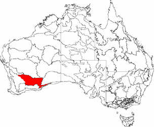
Mallee, also known as Roe Botanical District, is a biogeographic region in southern Western Australia. Located between the Esperance Plains, Avon Wheatbelt and Coolgardie bioregions, it has a low, gently undulating topography, a semi-arid mediterranean climate, and extensive Eucalyptus mallee vegetation. It has an area of 73,975.59 square kilometres (28,562.13 sq mi). About half of the region has been cleared for intensive agriculture. Recognised as a region under the Interim Biogeographic Regionalisation for Australia (IBRA), it was first defined by John Stanley Beard in 1980.

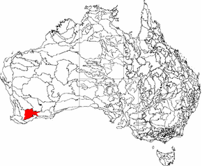
Warren, also known as Karri Forest Region and the Jarrah-Karri forest and shrublands ecoregion, is a biogeographic region in southern Western Australia. Located in the southwest corner of Western Australia between Cape Naturaliste and Albany, it is bordered to the north and east by the Jarrah Forest region. Its defining characteristic is an extensive tall forest of Eucalyptus diversicolor (karri). This occurs on dissected, hilly ground, with a moderately wet climate. Karri is a valuable timber and much of the karri forest has been logged over, but less than a third has been cleared for agriculture. Recognised as a region under the Interim Biogeographic Regionalisation for Australia (IBRA), and as a terrestrial ecoregion by the World Wide Fund for Nature, it was first defined by Ludwig Diels in 1906.

The High Rainfall Zone is one of three biogeographic zones into which south west Western Australia is divided, the others being the Transitional Rainfall Zone and the Low Rainfall Zone.
The Transitional Rainfall Zone (TRZ) is one of three biogeographic zones into which south-west Western Australia is divided, the others being the High Rainfall Zone and the Low Rainfall Zone. The TRZ is recognised as having a much higher diversity of rare and endemic plant species than the other Zones.
Western Mallee is an Interim Biogeographic Regionalisation for Australia (IBRA) subregion in southern Western Australia. It is a sparsely populated subregion with an area of about 47,000 square kilometres, roughly centred on the town of Newdegate. Largely cleared for intensive agriculture, it still retains patches of native vegetation, but these are under environmental stress from threats such as rising salinity, and are poorly managed.

Eastern Mallee is an Interim Biogeographic Regionalisation for Australia (IBRA) subregion in southern Western Australia.
Coolgardie is an Australian bioregion consisting of an area of low hills and plains of infertile sandy soil in Western Australia. It has an area of 129,122.09 square kilometres (49,854.32 sq mi). It includes much of the Great Western Woodlands.

Hampton is an interim Australian bioregion located in southeastern coastal Western Australia, with a small portion (4%) extending into adjacent South Australia. It has an area of 1,088,198 hectares. The Hampton bioregion is part of the Coolgardie woodlands ecoregion.

Yalgoo is an interim Australian bioregion located in Western Australia. It has an area of 5,087,577 hectares. The bioregion, together with the Avon Wheatbelt and Geraldton Sandplains bioregions, is part of the larger Southwest Australia savanna ecoregion as classified by the World Wildlife Fund.
The Western Australian Flora: A Descriptive Catalogue was published by the Wildflower Society of Western Australia, the Western Australian Herbarium, CALM, and the Botanic Gardens and Parks Authority of Perth, Western Australia.

The Great Sandy-Tanami desert is a ecoregion of Western Australia extending into the Northern Territory. It is designated as a World Wildlife Fund region.
Gunniopsis quadrifida, the Sturts pigface, is a plant endemic to Australia that is within the family Aizoaceae. This family consists of a diverse array of species that inhabit arid and/or saline coastal and inland areas, with the plants displaying leaf morphology that is conducive to such harsh environments. Typical features of members of this genus that lie within this family of succulents includes the presence of fleshy-leaves that acts as a water reservoir for the plant with the habit of a smalls shrub.

Stackhousia clementii is a species of plant in the family Celastraceae and is native to Australia.
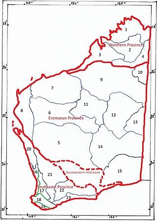
The botanical provinces of Western Australia (or Beard's Provinces) delineate "natural" phytogeographic regions of WA, based on climate and types of vegetation. John Stanley Beard, in "Plant Life of Western Australia" (p. 29-37) gives a short history of the various mappings.
References
- ↑ Gunawardene, Nihara (2003), Arid zone ant communities of Western Australia, Curtin University of Technology, Department of Environmental Biology, retrieved 10 January 2016
- ↑ "The Interior of Western Australia". The Northam Advertiser (WA : 1895 - 1918; 1948 - 1954) . WA: National Library of Australia. 16 July 1898. p. 2. Retrieved 10 January 2016.
- ↑ Warburton, Peter Egerton; Bates, Henry Walter, 1825-1892; Eden, Charles H. (Charles Henry), 1839-1900 (1981), Journey across the western interior of Australia (Facsimile ed.), Hesperian Press, ISBN 978-0-85905-031-9
{{citation}}: CS1 maint: multiple names: authors list (link) CS1 maint: numeric names: authors list (link) - ↑ Beard, J.S. (2015) 'Plant Life of Western Australia.' (2nd Ed.) Rosenberg Publishing Pty Ltd: Dural NSW. (CAB Direct)
- 1 2 "A visual guide to the Interim Biogeographic Regionalisation for Australia (IBRA) in WA". FloraBase: The Western Australian Flora. Western Australian Herbarium. Archived from the original on 17 October 2019. Retrieved 3 May 2014.
- ↑ not specifically named in the 1928 discussion, however the other provinces are clearly identified "NATURAL REGIONS". The West Australian (Perth, WA : 1879 - 1954) . Perth, WA: National Library of Australia. 14 March 1928. p. 14. Retrieved 10 January 2016.