Related Research Articles

Sudbury is a market town and civil parish in the south west of Suffolk, England, on the River Stour near the Essex border, 60 miles (97 km) north-east of London. It is the largest town in the Babergh local government district and part of the South Suffolk constituency. In 2021 the built-up area had a population of 23,912 and the parish had a population of 13,619.
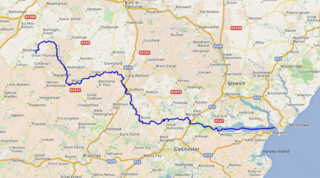
The River Stour is a major river in East Anglia, England. It is 47 miles (76 km) long and forms most of the county boundary between Suffolk to the north, and Essex to the south. It rises in eastern Cambridgeshire, passes to the east of Haverhill, through Cavendish, Sudbury, Bures, Nayland, Stratford St Mary and Dedham. It becomes tidal just before Manningtree in Essex and joins the North Sea at Harwich.

The Lee Navigation is a canalised river incorporating the River Lea. It flows from Hertford Castle Weir to the River Thames at Bow Creek; its first lock is Hertford Lock and its last Bow Locks.
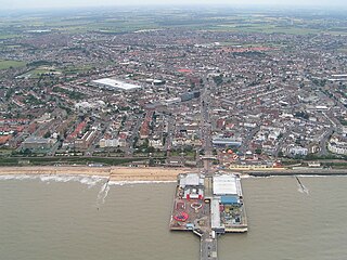
Tendring District is a local government district in north-east Essex, England. Its council is based in Clacton-on-Sea, the largest town. Other towns are Brightlingsea, Harwich, Frinton-on-Sea and Walton-on-the-Naze.

The Metropolitan Water Board was a municipal body formed in 1903 to manage the water supply in London, UK. The members of the board were nominated by the local authorities within its area of supply. In 1904 it took over the water supply functions from the eight private water companies which had previously supplied water to residents of London. The board oversaw a significant expansion of London's water supply infrastructure, building several new reservoirs and water treatment works.
The Thames Water Authority was one of ten regional water authorities created in the UK on 1 April 1974 under the provisions of the Water Act 1973 to bring together all the water management functions of the region in one public body.
The Water Act 1973 is an act of the Parliament of the United Kingdom that reorganised the water, sewage and river management industry in England and Wales. Water supply and sewage disposal were removed from local authority control, and ten larger regional water authorities were set up, under state control based on the areas of super-sets of river authorities which were also subsumed into the new authorities. Each regional water authority consisted of members appointed by the Secretary of State for the Environment, and by the various local authorities in its area.
River boards were authorities who controlled land drainage, fisheries and river pollution and had other functions relating to rivers, streams and inland waters in England and Wales between 1950 and 1965.
River authorities controlled land drainage, fisheries and river pollution in rivers, streams and inland waters in England and Wales between 1965 and 1973.

An internal drainage board (IDB) is a type of operating authority which is established in areas of special drainage need in England and Wales with permissive powers to undertake work to secure clean water drainage and water level management within drainage districts. The area of an IDB is not determined by county or metropolitan council boundaries, but by water catchment areas within a given region. IDBs are geographically concentrated in the Broads, Fens in East Anglia and Lincolnshire, Somerset Levels and Yorkshire.
Severn Trent Water Authority was one of ten regional water authorities established in 1974. Its area of operation was the catchments of the River Trent and River Severn. It assumed the powers and responsibilities of existing water supply authorities in those catchment areas, the Severn River Authority, the Trent River Authority and the sewage and sewage disposal responsibilities of the councils within its area.
A regional water authority, commonly known as a water board, was one of a group of public bodies that came into existence in England and Wales in April 1974, as a result of the Water Act 1973 coming into force. This brought together in ten regional units a diverse range of bodies involved in water treatment and supply, sewage disposal, land drainage, river pollution and fisheries. They lasted until 1989, when the water industry was privatised and the water supply and sewerage and sewage disposal parts became companies and the regulatory arm formed the National Rivers Authority. Regional water authorities were also part of the Scottish water industry when three bodies covering the North, West and East of Scotland were created in 1996, to take over responsibilities for water supply and sewage treatment from the regional councils, but they only lasted until 2002, when they were replaced by the publicly owned Scottish Water.
Anglian Water Authority was formed in 1974 by virtue of the Water Act 1973 as one of the regional water authorities. It established its headquarters in Huntingdon in Cambridgeshire. The authority boundary was the pre-existing boundaries of the constituent river authorities whose total area made Anglian Water Authority the largest of the ten newly created Authorities. It subsumed the roles and responsibilities of:
The Land Drainage Act 1930 was an act of Parliament passed by the United Kingdom Government which provided a new set of administrative structures to ensure that drainage of low-lying land could be managed effectively. It followed the proposals of a royal commission which sat during 1927.
The Land Drainage Act 1961 was an Act of Parliament passed by the United Kingdom Government which provided mechanisms for river boards to raise additional finance to fund their obligations. It built upon the provisions of the Land Drainage Act 1930 and the River Boards Act 1948.

The Water Resources Act 1963 is an act of the Parliament of the United Kingdom that continued the process of creating an integrated management structure for water, which had begun with the passing of the Land Drainage Act 1930. It created river authorities and a Water Resources Board. River authorities were responsible for conservation, re-distribution and augmentation of water resources in their area, for ensuring that water resources were used properly in their area, or were transferred to the area of another river authority. The river authorities covered the areas of one or more of the river boards created under the River Boards Act 1948, and inherited their duties and responsibilities, including those concerned with fisheries, the prevention of pollution, and the gauging of rivers. It did not integrate the provision of public water supply into the overall management of water resources, but it introduced a system of charges and licenses for water abstraction, which enabled the river authorities to allocate water to potential users. This included the water supply agencies, who now needed their supplies to be licensed.

The Water Act 1989 is an act of the Parliament of the United Kingdom that reorganised the bodies responsible for all aspects of water within England and Wales. Whereas previous legislation, particularly the Water Act 1973, had focused on providing a single unifying body with responsibility for all water-related functions within a river basin or series of river basins, this legislation divided those functions up again, with water supply, sewerage and sewage disposal being controlled by private companies, and the river management, land drainage and pollution functions becoming the responsibility of the National Rivers Authority.
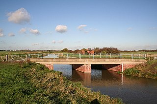
The River Till is a river in the county of Lincolnshire in England and is ultimately a tributary of the River Witham. Its upper reaches drain the land east of Gainsborough. The middle section is embanked, as the water level is higher than that of the surrounding land, and pumping stations pump water from low level drainage ditches into the river. Its lower reaches from the hamlet of Odder near Saxilby into the city of Lincoln were canalised, possibly as early as Roman times, as part of the Foss Dyke.

The River Boards Act 1948 was an Act of Parliament passed by the United Kingdom Government which provided constitutional, financial and general administrative structures for river boards, which were responsible for the management of river board areas, and superseded the catchment boards that had been set up under the Land Drainage Act 1930.

The Upper Witham IDB is an English Internal Drainage Board responsible for land drainage and the management of flood risk for an area to the west of the Lincolnshire city of Lincoln, broadly following the valleys of the upper River Witham, the River Till and the course of the Fossdyke Navigation.
References
- 1 2 3 4 Dobson, Alban; Hull, Hubert (1931). The Land Drainage Act 1930. Oxford: Oxford University Press.
- ↑ "Essex and Suffolk River Trust" . Retrieved 15 March 2024.
- ↑ "Essex Rivers House". Chelmsford Chronicle. 1 June 1934.
- 1 2 "Essex River Authority Act 1972" . Retrieved 15 March 2024.
- 1 2 3 4 5 6 7 "The development of the water industry in England and Wales" (PDF). Retrieved 15 March 2024.
- 1 2 3 4 5 Porter, Elizabeth (1978). Water Management in England and Wales. Cambridge University Press. ISBN 978-0-521-21865-8.
- ↑ "Land Drainage Act 1961" . Retrieved 15 March 2024.
- ↑ "A County told: a winter of Flood". News Chronicle. 26 September 1958.
- 1 2 "Water Resources Act 1963" (PDF). Retrieved 15 March 2024.
- ↑ "Essex River and South Essex Water Act 1969" (PDF). Retrieved 15 March 2024.
- ↑ Who was Who
- 1 2 "Water Act 1973" . Retrieved 15 March 2024.
- ↑ "Anglian Water Authority Constitution Order 1973" (PDF). Retrieved 19 March 2024.
- ↑ Anglia Water Authority, Annual Report and Account, various dates
- ↑ "Members named for Water Authority". Retford, Worksop, Isle of Axholme and Gainsborough News. 31 August 1973. p. 4.
- 1 2 "Water Act 1989" . Retrieved 15 March 2024.