Etna is a town in the Scott Valley area of Siskiyou County, California, United States. Its population is 678 as of the 2020 census, down from 737 from the 2010 census.

Etna Green is a town in Etna Township, Kosciusko County, in the U.S. state of Indiana. The population was 586 at the 2010 census.
Etna is a town in Penobscot County, Maine, United States. The population was 1,226 at the 2020 census.

Bullard is a small town in Smith and Cherokee counties in the east-central part of the U.S. state of Texas. U.S. Route 69 and Farm-to-Market Roads 2137, 2493, and 344 intersect here, about 15 miles (24 km) south of the larger city of Tyler. Its population was 3,318 at the 2020 census, up from 2,463 at the 2010 census.

Mount Etna, or simply Etna, is an active stratovolcano on the east coast of Sicily, Italy, in the Metropolitan City of Catania, between the cities of Messina and Catania. It is located above the convergent plate margin between the African Plate and the Eurasian Plate. It is one of the tallest active volcanoes in Europe, and the tallest peak in Italy south of the Alps with a current height of 3,403 m (11,165 ft), though this varies with summit eruptions. For instance, in 2021 the southeastern crater reached a height of 3,357 m, but was then surpassed by the Voragine crater after the summer 2024 eruptions.
Daisy is a small unincorporated community in Atoka County, Oklahoma, United States, along State Highway 43.

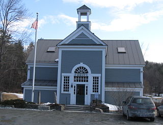
Etna, originally named "Mill Village", is a small community within the town of Hanover, New Hampshire, United States. It is located in southwestern Grafton County, approximately 3 miles (4.8 km) east of Hanover's downtown and 2.5 mi (4.0 km) south of the village of Hanover Center, on Mink Brook. Etna has a separate ZIP code 03750 from the rest of Hanover, as well as its own fire station, general store, ball field, playground, church, and library with adjacent conserved land and bird sanctuary. The population within Etna's ZIP Code area was 870 at the 2010 census.

Etna-Troy Township is one of nine townships in Whitley County, Indiana, United States. As of the 2020 census, its population was 1,863 and it contained 875 housing units.

Etna is an unincorporated town in Etna-Troy Township, Whitley County, in the U.S. state of Indiana.

Washington Township is one of twelve townships in Adams County, Iowa, United States. At the 2010 census, its population was 135.
Etna is an unincorporated community in Coles County, Illinois, United States. It lies at an elevation of 656 feet.
Etna is an unincorporated community in Bloomfield Township, Fillmore County, Minnesota, United States. Etna is located within ZIP code 55975 based in Spring Valley.
Etna is an unincorporated community in Scotland County, Missouri, United States. It lies at an elevation of 755 feet.
Etna is an unincorporated community in Custer County, Nebraska, United States. It lies at an elevation of 2,802 feet (854 m).
Etna is a former townsite, now a ghost town, in Pershing County, Nevada.

Etna is an unincorporated community and census-designated place (CDP) in Licking County, Ohio, United States. As of the 2020 census it had a population of 1,209. It lies at an elevation of 1,069 feet (326 m) at the intersection of U.S. Route 40 and State Route 310. It was listed as a census-designated place in 2010.

Etna Township is one of the 25 townships of Licking County, Ohio, United States. As of the 2020 census, the population was 18,896.
Cokeville was a town in Westmoreland County, Pennsylvania, United States. Following the St. Patrick's Day flood of 1936, the Army Corps of Engineers began planning a dam project on the Conemaugh River to harness the flood waters. There were 122 structures in Cokeville on a 1951 map. In 1952, as the town was being evacuated for the flood control project, most of these structures were razed, but some were moved up the hill to Cokeville Heights near Rt. 217.

Lorane is an unincorporated community in Etna-Troy Township, Whitley County, in the U.S. state of Indiana.

The Caves is a rural town and locality in the Livingstone Shire, Queensland, Australia. In the 2021 census, the locality of The Caves had a population of 680 people.


