Mill Plain, Washington

Last updated

Mill Plain, Washington
Clark County Washington Incorporated and Unincorporated areas Mill Plain Highlighted.svg
Location of Mill Plain, Washington
Coordinates: 45°38′38″N122°29′25″W / 45.64389°N 122.49028°W / 45.64389; -122.49028
CountryUnited States
State Washington
County Clark
Area
  Total
6.0 sq mi (15.5 km2)
  Land6.0 sq mi (15.5 km2)
  Water0.0 sq mi (0.0 km2)
Elevation
[1]
240 ft (70 m)
Population
 (2000)
  Total
7,400
  Density1,236.9/sq mi (477.6/km2)
Time zone UTC-8 (Pacific (PST))
  Summer (DST) UTC-7 (PDT)
FIPS code 53-45915 [2]
GNIS feature ID2408832 [1]

Mill Plain is an unincorporated area in Clark County, Washington, United States. At the 2000 census it was defined as a census-designated place (CDP) and had a population of 7,400. The area was not listed as a CDP for the 2010 census.[ citation needed ]

Contents

Geography

The Mill Plain area is located in southern Clark County. The community bordered by the city of Vancouver to the west and south and by the city of Camas to the southeast.

According to the United States Census Bureau, in 2000 the CDP had a total area of 6.0 square miles (15.5 km2), all of it land.

Demographics

As of the census [2] of 2000, there were 7,400 people, 2,379 households, and 1,953 families residing in the CDP. The population density was 1,236.9 inhabitants per square mile (477.6/km2). There were 2,500 housing units at an average density of 417.9 per square mile (161.4/km2). The racial makeup of the CDP was 87.34% White, 1.62% African American, 0.57% Native American, 6.23% Asian, 0.11% Pacific Islander, 0.59% from other races, and 3.54% from two or more races. Hispanic or Latino of any race were 2.66% of the population.

There were 2,379 households, out of which 49.7% had children under the age of 18 living with them, 71.0% were married couples living together, 7.7% had a female householder with no husband present, and 17.9% were non-families. 12.6% of all households were made up of individuals, and 3.5% had someone living alone who was 65 years of age or older. The average household size was 3.11 and the average family size was 3.41.

In the CDP the age distribution of the population shows 34.5% under the age of 18, 7.2% from 18 to 24, 35.3% from 25 to 44, 17.3% from 45 to 64, and 5.7% who were 65 years of age or older. The median age was 30 years. For every 100 females, there were 99.2 males. For every 100 females age 18 and over, there were 95.4 males.

The median income for a household in the CDP was $58,432, and the median income for a family was $59,386. Males had a median income of $45,385 versus $26,803 for females. The per capita income for the CDP was $21,181. About 7.6% of families and 10.3% of the population were below the poverty line, including 15.8% of those under age 18 and 8.1% of those age 65 or over.

Related Research Articles

<span class="mw-page-title-main">Moores Mill, Alabama</span> Census-designated place in Alabama, United States

Moores Mill is an unincorporated community and census-designated place (CDP) in Madison County, Alabama, United States, and is included in the Huntsville-Decatur Combined Statistical Area. The population was 6,729 at the 2020 census, up from 5,682 at the 2010 census.

<span class="mw-page-title-main">Tamalpais-Homestead Valley, California</span> Census-designated place in California, United States

Tamalpais-Homestead Valley is a census-designated place (CDP) in Marin County, California, United States. The population was 11,492 at the 2020 census.

<span class="mw-page-title-main">Thompsonville, Connecticut</span> Census-designated place in Connecticut, United States

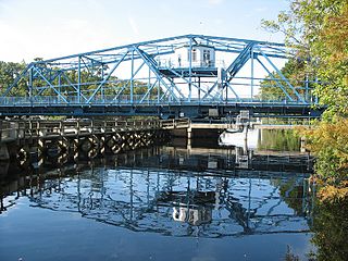
Thompsonville is a census-designated place (CDP) in the town of Enfield in Hartford County, Connecticut, United States. The population of the CDP was 8,577 at the 2010 census.

<span class="mw-page-title-main">ʻEwa Gentry, Hawaii</span> Census-designated place in Hawaii, United States

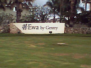
ʻEwa Gentry is a housing development and, as Ewa Gentry, a census-designated place (CDP) located in the ʻEwa District and the City & County of Honolulu on the leeward side of Oʻahu in Hawaiʻi about twelve miles (19 km) from Honolulu. As of the 2010 Census, the CDP had a total population of 22,690.

<span class="mw-page-title-main">Ramblewood, New Jersey</span> Populated place in Burlington County, New Jersey, US

Ramblewood is an unincorporated community and census-designated place (CDP) located within Mount Laurel in Burlington County, in the U.S. state of New Jersey. As of the 2010 United States Census, the CDP's population was 5,907.

<span class="mw-page-title-main">Brownville, New Jersey</span> Populated place in Middlesex County, New Jersey, US

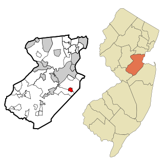
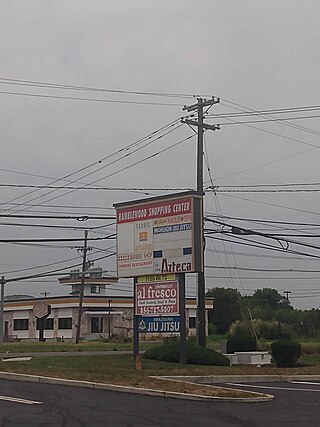
Brownville is an unincorporated community and census-designated place (CDP) in Old Bridge Township, Middlesex County, New Jersey, United States. As of the 2020 census, the population was 2,746, up from 2,383 in 2010.

Clark Mills is a hamlet in Oneida County, New York, United States. The population was 1,905 at the 2010 census.

<span class="mw-page-title-main">Firthcliffe, New York</span> CDP in New York, United States

Firthcliffe is a hamlet in Orange County, New York United States. The population was 5,022 at the 2020 Census. It is part of the Poughkeepsie–Newburgh–Middletown, NY Metropolitan Statistical Area as well as the larger New York–Newark–Bridgeport, NY-NJ-CT-PA Combined Statistical Area.

<span class="mw-page-title-main">Highland Mills, New York</span> Former CDP in New York, United States

Highland Mills is a hamlet and former census-designated place (CDP) in Orange County, New York, United States. The population was 3,468 at the 2000 census. It is part of the Poughkeepsie–Newburgh–Middletown, NY Metropolitan Statistical Area as well as the larger New York–Newark–Bridgeport, NY-NJ-CT-PA Combined Statistical Area.

Gang Mills is a hamlet in Steuben County, New York. The population was 4,185 at the 2010 census.

Plain View is a census-designated place (CDP) in Sampson County, North Carolina, United States. The population was 1,923 at the 2020 census.

<span class="mw-page-title-main">White Plains, North Carolina</span> CDP in North Carolina, United States

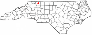
White Plains is a census-designated place (CDP) in Surry County, North Carolina, United States. The population was 1,049 at the 2000 census.

<span class="mw-page-title-main">Spring Mills, Pennsylvania</span> Census designated place in Pennsylvania, United States

Spring Mills is an unincorporated community and census-designated place (CDP) in Centre County, Pennsylvania, United States. It is part of the State College, Pennsylvania Metropolitan Statistical Area. The population was 268 at the 2010 census.

<span class="mw-page-title-main">Mount Pleasant Mills, Pennsylvania</span> CDP in Pennsylvania, United States

Mount Pleasant Mills is a census-designated place (CDP) in Snyder County, Pennsylvania, United States. The population was 342 at the 2000 census.

<span class="mw-page-title-main">Socastee, South Carolina</span> CDP in South Carolina, United States

Socastee is a census-designated place (CDP) in Horry County, South Carolina, United States. The population was 19,952 at the 2010 census.

<span class="mw-page-title-main">Inman Mills, South Carolina</span> CDP in South Carolina, United States

Inman Mills is a census-designated place (CDP) in Spartanburg County, South Carolina, United States. The population was 1,050 at the 2010 census.

<span class="mw-page-title-main">Monarch Mill, South Carolina</span> CDP in South Carolina, United States

Monarch Mill is a census-designated place (CDP) in Union County, South Carolina, United States. The population was 1,811 at the 2010 census.

<span class="mw-page-title-main">Elk Plain, Washington</span> CDP in Washington, United States

Elk Plain is a census-designated place (CDP) in Pierce County, Washington, United States. The population was 14,534 at the 2020 census.

<span class="mw-page-title-main">Loveland Park, Ohio</span> Census-designated place in Ohio, United States

Loveland Park is a census-designated place (CDP) located in Symmes Township, Hamilton County and Deerfield Township, Warren County, in the southwestern part of the U.S. state of Ohio. The CDP is named after the city of Loveland. The population was 1,737 at the 2020 census.

<span class="mw-page-title-main">Pine Plains (CDP), New York</span> Census-designated place in New York, United States

Pine Plains is a hamlet and census-designated place (CDP) in Dutchess County, New York, United States. The population was 1,142 at the 2020 census. It is part of the Poughkeepsie–Newburgh–Middletown, NY Metropolitan Statistical Area as well as the larger New York–Newark–Bridgeport, NY-NJ-CT-PA Combined Statistical Area.

References

  1. 1 2 U.S. Geological Survey Geographic Names Information System: Mill Plain, Washington
  2. 1 2 "U.S. Census website". United States Census Bureau . Retrieved January 31, 2008.