Parkes is a town in the Central West region of New South Wales, Australia. It is the main settlement in the local government area of Parkes Shire. Parkes has a population of 10,919 at the 2021 census.

Cobar is a town in central western New South Wales, Australia whose economy is based mainly upon base metals and gold mining. The town is 712 km (442 mi) by road northwest of the state capital, Sydney. It is at the crossroads of the Kidman Way and Barrier Highway. The town and the local government area, the Cobar Shire, are on the eastern edge of the outback. At the 2016 census, the town of Cobar had a population of 3,990. The Shire has a population of approximately 4,700 and an area of 44,065 square kilometres (17,014 sq mi).

Nyngan is a town in the centre of New South Wales, Australia, in the Bogan Shire local government area within the Orana Region of central New South Wales. At the 2016 census, Nyngan had a population of 1,988 people. Nyngan is situated on the Bogan River between Narromine and Bourke, on the junction of the Mitchell Highway and Barrier Highway, 656 km (408 mi) south of Charleville and 576 km (358 mi) north-west of Sydney by road. The Barrier Highway starts at Nyngan, and runs west to Cobar and on through Wilcannia and Broken Hill into South Australia.

Gunnedah is a town in north-central New South Wales, Australia and is the seat of the Gunnedah Shire local government area. In the 2021 census the town recorded a population of 8,338. Gunnedah is situated within the Liverpool Plains, a fertile agricultural region, with 80% of the surrounding shire area devoted to farming. The Namoi River flows west then north-west through the town providing water beneficial to agricultural operations in the area.

CountryLink was a passenger rail and road service brand that operated in regional areas of New South Wales, and to and from Canberra, Brisbane and Melbourne. Originally created as a business unit of the State Rail Authority of New South Wales, it later became a subsidiary of RailCorp. CountryLink operated rail services using XPT and Xplorer rolling stock, with connecting coach services operated under contract by private operators.

The Main North Line is a major railway in New South Wales, Australia. It runs through Strathfield to Armidale. The line is the main line between Sydney and Armidale. As of 1988, the line closed progressively north of Armidale with services gradually withdrawn till 2004, with the main route between Sydney and Brisbane now the North Coast line. The end of these services marked a significant shift in rail transport in the region, leading to an increased reliance on road transport and altering the dynamics of movement and passenger accessibility between these major cities..

Narrabri is a locality and seat of Narrabri Shire local government area in the North West Slopes, New South Wales, Australia on the Namoi River, 521 kilometres (324 mi) northwest of Sydney. It sits on the junction of the Kamilaroi Highway and the Newell Highway. At the 2021 census, the town of Narrabri had a population of 5,499.

Liverpool railway station is a heritage-listed railway station located on the Main Southern line, serving the Sydney suburb of Liverpool in Australia. It is served by Sydney Trains T2 Inner West & Leppington, T3 Bankstown and T5 Cumberland services. It was added to the New South Wales State Heritage Register on 2 April 1999.

The Bankstown Line is a commuter rail line operated by Sydney Trains in Sydney, New South Wales, Australia. It serves Canterbury-Bankstown and parts of the Inner West and Western Sydney. The Bankstown railway line is the physical railway line which carries the section of the Bankstown Line between Sydenham and Birrong.
The Central Coast & Newcastle Line (CCN) is a NSW TrainLink passenger train service that runs along the Main North railway line in New South Wales, connecting the state's two largest cities, Sydney and Newcastle. The service runs from Central through to Broadmeadow on the Main North railway line to Newcastle Interchange on the Newcastle railway line, and services the Hawkesbury River region, the Central Coast and the city of Newcastle.
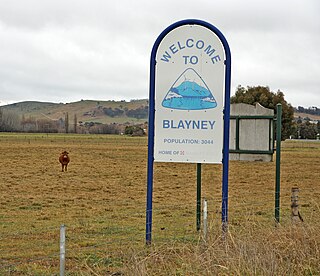
Blayney is a farming town and administrative centre with a population of 2,997 in 2021, in the Central West region of New South Wales, Australia. Situated on the Mid-Western Highway about 240 km (150 mi) west of Sydney, 35 km (22 mi) west of Bathurst and 863 m (944 yd) above sea-level, Blayney is the seat of Blayney Shire Council.

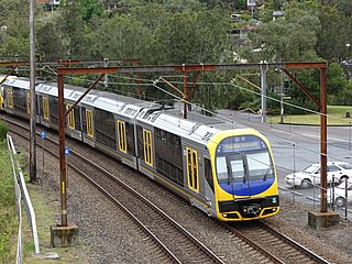
Sydney, the largest city in Australia, has an extensive network of passenger and goods railways. The passenger system includes an extensive suburban railway network, operated by Sydney Trains, a metro system and a light rail network. A dedicated goods network also exists.
The Main Western Railway is a major railway in New South Wales, Australia. It runs through the Blue Mountains, and Central West regions. It is 825 kilometres (513 mi) long, of which 484 kilometres (301 mi) is currently operational.

Byrock is a small village in north western New South Wales, Australia in Bourke Shire. In 2016, Byrock had a population of 50 people.
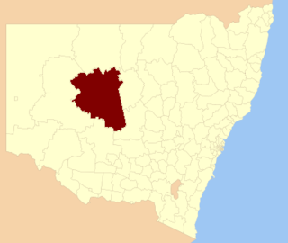
Cobar Shire is a local government area in the Orana region of New South Wales, Australia. The Shire is located in an outback area that is centred around the mining town of Cobar. The Shire is traversed by the Barrier Highway and the Kidman Way. With a total area of 44,065 square kilometres (17,014 sq mi), about two-thirds the size of Tasmania, Cobar Shire is larger than Denmark and 99 other countries and self-governing territories, but its population is under 5000.
The railways of New South Wales, Australia have had many incidents and accidents since their formation in 1831. There are close to 1000 names associated with rail-related deaths in NSW on the walls of the Australian Railway Monument in Werris Creek. Those killed were all employees of various NSW railways. The details below include deaths of employees and the general public.
The Mount Hope railway briefly connected the Broken Hill railway line with Mount Hope, New South Wales, Australia. The copper mine for which this branch was constructed to service ceased full-time operations four months before the line was opened. After a bare five years, the branch itself was closed—possibly the first step of rationalisation to be practiced by the New South Wales Government Railways.

The Northern Sydney Freight Corridor (NSFC) was a project to improve access between Sydney and Newcastle for freight trains. Frequent passenger services operate on the Main Northern line between Strathfield and Broadmeadow. These passenger services take priority, meaning freight trains can be delayed and are subject to a curfew during peak hours. The Northern Sydney Freight Corridor aimed to reduce delays and increase capacity by providing additional train paths. The delivery of the NSFC projects was managed by Transport for NSW, with the exception of the Hexham freight loop which was delivered in June 2012 by the Australian Rail Track Corporation. The final stage was completed in June 2016.
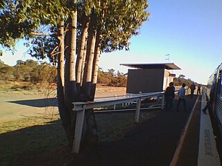
Euabalong West railway station is located on the Broken Hill line in New South Wales, Australia. It serves the town of Euabalong West.

Euabalong is a town in western New South Wales, Australia. The town is in the Cobar Shire local government area and on the Lachlan River, 531 kilometres (330 mi) west of the state capital, Sydney, and 27 kilometres from Lake Cargelligo.