Related Research Articles

An earthquake – also called a quake, tremor, or temblor – is the shaking of the Earth's surface resulting from a sudden release of energy in the lithosphere that creates seismic waves. Earthquakes can range in intensity, from those so weak they cannot be felt, to those violent enough to propel objects and people into the air, damage critical infrastructure, and wreak destruction across entire cities. The seismic activity of an area is the frequency, type, and size of earthquakes experienced over a particular time. The seismicity at a particular location in the Earth is the average rate of seismic energy release per unit volume.
Megathrust earthquakes occur at convergent plate boundaries, where one tectonic plate is forced underneath another. The earthquakes are caused by slip along the thrust fault that forms the contact between the two plates. These interplate earthquakes are the planet's most powerful, with moment magnitudes (Mw) that can exceed 9.0. Since 1900, all earthquakes of magnitude 9.0 or greater have been megathrust earthquakes.

The 1946 Aleutian Islands earthquake occurred near the Aleutian Islands, Alaska on April 1, 1946. The shock measured 8.6, Mt 9.3 or 7.4. It had a maximum Mercalli intensity of VI (Strong). It resulted in 165–173 casualties and over US $26 million in damage. The seafloor along the fault was elevated, triggering a Pacific-wide tsunami with multiple destructive waves at heights ranging from 45–138 ft (14–42 m). The tsunami obliterated the Scotch Cap Lighthouse on Unimak Island, Alaska among others, and killed all five lighthouse keepers. Despite the destruction to the Aleutian Island Unimak, the tsunami had almost an imperceptible effect on the Alaskan mainland.

Many major earthquakes have occurred in the region of the Kamchatka Peninsula in far eastern Russia. Events in 1737, 1923 and 1952, were megathrust earthquakes and caused tsunamis. There are many more earthquakes and tsunamis originating from the region.

The 2004 Al Hoceima earthquake occurred on 24 February at 02:27:47 local time near the coast of northern Morocco. The strike-slip earthquake measured 6.3 on the moment magnitude scale and had a maximum perceived intensity of IX (Violent) on the Mercalli intensity scale. Between 628 and 631 people were killed, 926 injured, and up to 15,000 people were rendered homeless in the Al Hoceima-Imzourene-Beni Abdallah area.
The 1952 Severo-Kurilsk earthquake struck off the coast of the Kamchatka Peninsula. The 9.0 Mw earthquake triggered a major tsunami that hit Severo-Kurilsk, Kuril Islands, Sakhalin Oblast, Russian SFSR, USSR, on 5 November 1952 at 04:58 local time. This led to the destruction of many settlements in Sakhalin Oblast and Kamchatka Oblast, while the main impact struck the town of Severo-Kurilsk. It was the most powerful earthquake ever recorded in Russia, and the fifth most powerful earthquake ever recorded in the world since modern seismography began in 1900.
The EUR-OPA Major Hazards Agreement is a Partial Agreement of the Council of Europe, set up in 1987 by Resolution (87) 2 of the Committee of Ministers. Its full name is "Co-operation Group for the Prevention of, Protection Against, and Organisation of Relief in Major Natural and Technological Disasters (EUR-OPA)".
The Swiss Seismological Service at ETH Zurich is the federal agency responsible for monitoring earthquakes in Switzerland and its neighboring countries and for assessing Switzerland's seismic hazard. When an earthquake happens, the SED informs the public, authorities, and the media about the earthquake's location, magnitude, and possible consequences. The activities of the SED are integrated in the federal action plan for earthquake precaution.
The 1995 Gulf of Aqaba earthquake occurred on November 22 at 06:15 local time and registered 7.3 on the Mw scale. The epicenter was located in the central segment of the Gulf of Aqaba, the narrow body of water that separates Egypt's Sinai Peninsula from the western border of Saudi Arabia. At least 8 people were killed and 30 were injured in the meizoseismal area.

The National Tsunami Warning Center (NTWC) is one of two tsunami warning centers in the United States, covering all coastal regions of the United States and Canada, except Hawaii, Guam, the Northern Mariana Islands, Puerto Rico and the U.S. Virgin Islands. Until 2013, it was known as the West Coast and Alaska Tsunami Warning Center.
Recent advances are improving the speed and accuracy of loss estimates immediately after earthquakes so that injured people may be rescued more efficiently. "Casualties" are defined as fatalities and injured people, which are due to damage to occupied buildings. After major and large earthquakes, rescue agencies and civil defense managers rapidly need quantitative estimates of the extent of the potential disaster, at a time when information from the affected area may not yet have reached the outside world. For the injured below the rubble every minute counts. To rapidly provide estimates of the extent of an earthquake disaster is much less of a problem in industrialized than in developing countries. This article focuses on how one can estimate earthquake losses in developing countries in real time.
The 1959 Kamchatka earthquake occurred on May 4 at 19:15 local time with a moment magnitude of 8.0–8.3, and a surface wave magnitude of 8.25. The epicenter was near the Kamchatka Peninsula, Russian SFSR, USSR. Building damage was reported in Petropavlovsk-Kamchatsky. The maximum intensity was VIII (Damaging) on the Medvedev–Sponheuer–Karnik scale. The intensity in Petropavlovsk-Kamchatsky was about VIII MSK.
The European-Mediterranean Seismological Centre is an international, non-governmental and not-for-profit organisation.

The 2014 Guerrero earthquake occurred with a moment magnitude of 7.2 that hit the state of Guerrero, close to Acapulco, Mexico, on 18 April at 14:27:26 UTC. The epicenter occurred 265 kilometers southwest of Mexico City and at a depth of 24 kilometers. Thrust motion at shallow depths is what caused the earthquake. This was broadly consistent with a slip on or near the Guerrero Seismic Gap, a boundary between the Cocos and North American plates along the Pacific Coast approximately 200 kilometers long. The shaking was felt in states as far away as Puebla and Tlaxcala.
The February 1923 Kamchatka earthquake occurred on 3 February 1923. The epicenter was on the southeastern coast of the Kamchatka Peninsula. The earthquake triggered a tsunami with wave heights up to eight metres, causing damage as far away as Hawaii. The maximum perceived Mercalli intensity was XI (Extreme). The tsunami caused two deaths in Kamchatka and one in Hawaii.
The National Centre for Seismology (NCS) is an office of India's Ministry of Earth Sciences. The office monitors earthquakes and conducts seismological research. Specifically, it provides earthquake surveillance and hazard reports to governmental agencies. It consists of various divisions:

The Valparaíso earthquake of April 2017 was a strong earthquake that shook the cities of Valparaíso and Santiago on Monday, April 24, 2017, at 18:38 local time. Its epicenter was located off the coast of the Valparaíso Region and had a magnitude of 6.9 Mw. On the scale of Mercalli, the earthquake reached an intensity of VII.
On April 13, 1923 at 15:31 UTC, an earthquake occurred off the northern coast of the Kamchatka Peninsula in the USSR, present-day Russia. The earthquake had a surface-wave magnitude (Ms ) of 6.8–7.3 and an estimated moment magnitude (Mw ) of 7.0–8.2. This event came just two months after a slightly larger earthquake with an epicenter struck south of the April event. Both earthquakes were tsunamigenic although the latter generated wave heights far exceeding that of the one in February. After two foreshocks of "moderate force", the main event caused considerable damage. Most of the 36 casualties were the result of the tsunami inundation rather than the earthquake.

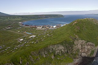
An earthquake occurred off the coast of the Alaska Peninsula on July 28, 2021, at 10:15 p.m. local time. The large megathrust earthquake had a moment magnitude of 8.2 according to the United States Geological Survey (USGS). A tsunami warning was issued by the National Oceanic and Atmospheric Administration (NOAA) but later cancelled. The mainshock was followed by a number of aftershocks, including three that were of magnitude 5.9, 6.1 and 6.9 respectively.
The 1841 Kamchatka earthquake occurred in the Pacific Ocean on May 17 at 08:00 local time. The earthquake had an epicenter off the Russian Far East's Kamchatka Peninsula. With an estimated moment magnitude of 9.0 or higher, it is one of the largest to strike the region. A large tsunami with up to 15 meters in run-up along the coast.
References
- ↑ European-Mediterranean Seismological Centre (EMSC) Archived 2008-10-20 at the Wayback Machine
- ↑ EMSC History