Related Research Articles

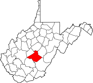
Nicholas County is a county located in the central region of U.S. state of West Virginia. As of the 2020 census, the population was 24,604. Its county seat is Summersville. The county was created in 1818 by the Virginia General Assembly and named for Virginia Governor Wilson Cary Nicholas.

Summersville is a city in Nicholas County, West Virginia, United States. The population was 3,459 at the 2020 census. It is the county seat of Nicholas County.

Wilson Cary Nicholas was an American politician who served in the U.S. Senate from 1799 to 1804 and was the 19th Governor of Virginia from 1814 to 1816.

West Virginia's 2nd congressional district consists of the northern half of the state. It contains Barbour, Berkeley, Brooke, Doddridge, Grant, Hampshire, Hancock, Hardy, Harrison, Jefferson, Lewis, Marion, Marshall, Mineral, Monongalia, Morgan, Ohio, Pleasants, Preston, Randolph, Ritchie, Taylor, Tucker, Tyler, Upshur, Wetzel, and Wood counties.

West Virginia's 3rd congressional district is an obsolete U.S. congressional district in southern West Virginia. At various times the district covered different parts of the state, but in its final form included the state's second-largest city, Huntington; included Bluefield, Princeton, and Beckley; and has a long history of coal mining, forestry, and farming.

Southern West Virginia is a culturally and geographically distinct region in the U.S. state of West Virginia. Southern West Virginia is known for its coal mining heritage and Southern affinity. The region is also closely identified with Southwestern Virginia and Southeastern Kentucky, with close proximity to Western North Carolina and East Tennessee. Today, Southern West Virginia continues to grapple with poverty and declining population. The region is located in West Virginia's 1st congressional district, which is represented by Carol Miller.

The U.S. state of West Virginia was formed out of western Virginia and added to the Union as a direct result of the American Civil War, in which it became the only modern state to have declared its independence from the Confederacy. In the summer of 1861, Union troops, which included a number of newly formed Western Virginia regiments, under General George McClellan, drove off Confederate troops under General Robert E. Lee. This essentially freed Unionists in the northwestern counties of Virginia to form a functioning government of their own as a result of the Wheeling Convention. Prior to the admission of West Virginia the government in Wheeling formally claimed jurisdiction over all of Virginia, although from its creation it was firmly committed to the formation of a separate state.
Samuel Price was Virginia lawyer and politician, who helped to establish the state of West Virginia during the American Civil War and became Lieutenant Governor, and later a United States senator.
Larry Alan Tucker was an American politician.

John D. Alderson was a lawyer and Democratic politician from West Virginia who served as a United States representative from West Virginia.
Belva is an unincorporated community and census-designated place in west Nicholas County and north Fayette County, West Virginia, United States; while the CDP only includes the Nicholas County portion, the Fayette County portion is considered part of the community. The town is situated at the bottomland surrounding the convergence of Bells Creek with Twentymile Creek and, subsequently, Twenty Mile Creek with the Gauley River. Belva is also the location of the convergence of two state highways: West Virginia Route 16 and West Virginia Route 39.
Lockwood is an unincorporated community in western Nicholas County, West Virginia, United States. The town is situated along Otter Creek and West Virginia Route 39.
Tioga is a census-designated place (CDP) in northeastern Nicholas County, West Virginia, United States. As of the 2010 census, its population was 98. The town is located along a road alternatively called Tioga Road in Nicholas County and Strouds Creek Road in Webster County. The road can be accessed from West Virginia Route 20 in Allingdale and West Virginia Route 55 near Craigsville.
This is a list of the National Register of Historic Places listings in Nicholas County, West Virginia.
Dixie is a census-designated place (CDP) in Fayette and Nicholas counties, West Virginia, United States. Dixie is located on West Virginia Route 16, 5.5 miles (8.9 km) north of Gauley Bridge. Dixie has a post office with ZIP code 25059. As of the 2010 census, its population was 291, with 202 residents in Nicholas County and 89 in Fayette County.
Green Valley is an unincorporated community in Nicholas County, West Virginia, United States. Green Valley is located along West Virginia Route 20, 3 miles (4.8 km) north of Quinwood.
Kate's Mountain, south of White Sulphur Springs in Greenbrier County, West Virginia, was named for Catherine "Kate" Carpenter, who in September 1756 took refuge with her child on the mountain's peak during an Indian attack in which her husband Nicholas Carpenter was killed near Fort Dinwiddie in the vicinity of White Sulphur Springs, West Virginia. Kate's Mountain is the highest of the peaks in Greenbrier State Forest at 3,280 feet. Kate's Mountain was the inspiration for the 19th Century romantic poem The Mystic Circle of Kate's Mountain, first published in fragmentary form in 1860 and published in its entirety in 1895. Kate's Mountain is the type location for Kate's Mountain clover, Trifolium virginicum, the symbol of the West Virginia Native Plant Society.

The 1996 United States presidential election in West Virginia took place on November 5, 1996, as part of the 1996 United States presidential election. Voters chose five representatives, or electors to the Electoral College, who voted for president and vice president.

The 1912 United States presidential election in West Virginia took place on November 5, 1912, as part of the 1912 United States presidential election. West Virginia voters chose eight representatives, or electors, to the Electoral College, who voted for president and vice president.
References
- ↑ U.S. Geological Survey Geographic Names Information System: Eye, West Virginia
- ↑ "Eye (Nicholas County, WV)". roadsidethoughts.com. Retrieved 2023-05-15.
- ↑ Business Atlas and Shippers' Guide. Rand McNally & Co. 1895.
Municipalities and communities of Nicholas County, West Virginia, United States | ||
|---|---|---|
| City |  | |
| CDPs | ||
| Unincorporated communities |
| |
| Ghost towns | ||
| Footnotes | ‡This populated place also has portions in an adjacent county or counties | |
| | This article about a location in Nicholas County, West Virginia is a stub. You can help Wikipedia by expanding it. |