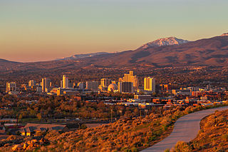
Reno is a city in the northwest section of the U.S. state of Nevada, along the Nevada–California border. It is the county seat and most populous city of Washoe County. Sitting in the High Eastern Sierra foothills, in the Truckee River valley, on the eastern side of the Sierra Nevada, it is about 23 miles (37 km) northeast of Lake Tahoe. Known as "The Biggest Little City in the World", it is the 80th most populous city in the United States, the fourth most populous city in Nevada, and the most populous in Nevada outside the Las Vegas Valley. The city had a population of 264,165 at the 2020 census.

Winter Park is a city in Orange County, Florida, United States. The population was 29,795 according to the 2020 census. It is part of the Orlando–Kissimmee–Sanford, Florida Metropolitan Statistical Area.

Reston is a census-designated place in Fairfax County, Virginia, United States, and a principal city of both Northern Virginia and the Washington metropolitan area. As of the 2020 U.S. census, Reston's population was 63,226.

Luray is the county seat of Page County, Virginia, United States, in the Shenandoah Valley in the northern part of the Commonwealth. The population was 4,831 at the 2020 census.

Falmouth is a census-designated place (CDP) in Stafford County, Virginia, United States. Situated on the north bank of the Rappahannock River at the falls, the community is north of and opposite the city of Fredericksburg. Recognized by the U.S. Census Bureau as a census-designated place (CDP), Falmouth's population was 4,956 as of the 2020 census.
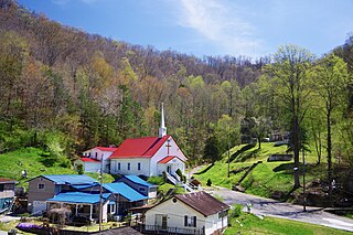
Kermit is a town in Mingo County, West Virginia, United States. The population was 406 at the 2010 census. Kermit is located along the Tug Fork, opposite Warfield, Kentucky. The Norfolk Southern Railway's Kenova District runs through town.
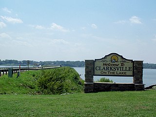
Clarksville is a town in Mecklenburg county in the U.S. state of Virginia, near the southern border of the commonwealth. The population was 1,139 at the 2010 census. Since the town has numerous buildings of the 18th-, 19th-, and early 20th-century architecture, the downtown area of Clarksville has been designated a Historic District on the National Register of Historic Places and Virginia's Historic Register. Clarksville claims the title of Virginia's only lakeside town. Nearby the town of Clarksville is Occoneechee State Park.

Snowbird is an unincorporated community in Little Cottonwood Canyon in the Wasatch Range of the Rocky Mountains near Salt Lake City, Utah, United States. It is most famous for Snowbird Ski and Summer Resort, an alpine skiing and snowboarding area, which opened in December 1971.

The Pah Rah Range is a mountain range located in western Nevada in Washoe County just to the northeast of Reno. It is a hook shaped range with the main eastern portion oriented northwest–southeast, approximately 20 miles (32 km) long. The northwest flowing Cottonwood Creek in Warm Springs Valley is bounded on three sides by the range. To the south and east the Truckee River forms the boundary and Pyramid Lake is at the northeast. Spanish Springs Valley north of Reno forms the southwest margin. To the north, the narrow Mullen Pass separates the Pah Rah Range from the Virginia Mountains.

Rodanthe is an unincorporated community and census-designated place (CDP) located in Dare County, North Carolina, United States, on Hatteras Island, part of North Carolina's Outer Banks. As of the 2020 census it had a population of 213. Rodanthe, along with Waves and Salvo, are part of the settlement of Chicamacomico. Rodanthe includes the original Chicamacomico Life-Saving Station, decommissioned in 1954, but now a museum.

Western Maryland, also known as the Maryland panhandle or Mountain Maryland, is the portion of the U.S. state of Maryland that typically consists of Frederick, Washington, Allegany, and Garrett counties. The region is bounded by Preston County, West Virginia, to the west, the Mason–Dixon line (Pennsylvania) to the north, and the Potomac River and West Virginia to the south. At one point, at the town of Hancock, the northern and southern boundaries are separated by just 1.8 miles, the narrowest stretch in the state.
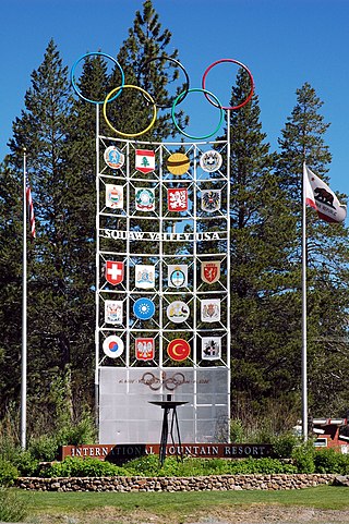
Olympic Valley is an unincorporated community located in Placer County, California northwest of Tahoe City along California State Highway 89 on the banks of the Truckee River near Lake Tahoe. It is home to Palisades Tahoe, the site of the 1960 Winter Olympics. Olympic Valley is the smallest resort area to host the Olympic Winter Games.

Jindabyne is a town in south-east New South Wales, Australia that overlooks Lake Jindabyne near the Snowy Mountains, in Snowy Monaro Regional Council. It is a popular holiday destination year round, especially in winter. This is due to its proximity to major ski resort developments within the Kosciuszko National Park, including Thredbo, Perisher and Charlotte Pass.

Sparks is an unincorporated community that is located in Baltimore County, Maryland, United States. It is situated approximately 20 miles (32 km) north of Baltimore and is considered to be a suburb of the City of Baltimore. The Gunpowder River runs through Sparks.
The Boundary Country is a historical designation for a district in southern British Columbia lying, as its name suggests, along the boundary between Canada and the United States. It lies to the east of the southern Okanagan Valley and to the west of the West Kootenay. It is often included in descriptions of both of those regions but historically has been considered a separate region. Originally inclusive of the South Okanagan towns of Osoyoos and Oliver, today the term continues in use to refer to the valleys of the Kettle, West Kettle, and Granby Rivers and of Boundary and Rock Creeks and that of Christina Lake and of their various tributaries, all draining the south slope of the Monashee Mountains. The term Boundary District as well as the term Boundary Country can both refer to the local mining division of the British Columbia Ministry of Mines, Energy and Petroleum Resources.

Oak Lake is an unincorporated urban community in the Rural Municipality of Sifton within the Canadian province of Manitoba that held town status prior to January 1, 2015. It is located 52 km (32 mi) west of Brandon along the Trans-Canada Highway. The lake after which it was named is in the rural municipality's western area.

Coopers Rock State Forest is a 12,747-acre (52 km2) state forest in Monongalia and Preston counties in the U.S. state of West Virginia. Its southern edge abuts Cheat Lake and the canyon section of Cheat River, a popular whitewater rafting river in the eastern United States.
Mossbank is a town in the Canadian province of Saskatchewan. The town is south of Old Wives Lake and 68 km south of Moose Jaw.

Newport is an unincorporated community in Giles County, Virginia, United States, with the ZIP code of 24128. The 2020 Census reports a population of 1,767 in the community. It is located in a valley between Salt Pond Mountain, Sherman's Nose and Gap Mountain.

Snowville is a census-designated place (CDP) located in southeastern Pulaski County in the Commonwealth of Virginia. The population, as of the 2010 Census, was 149. It is part of the Blacksburg–Christiansburg Metropolitan Statistical Area.


