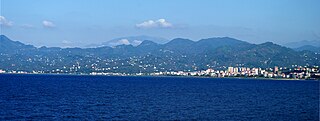
Trabzon, historically known as Trebizond, is a city on the Black Sea coast of northeastern Turkey and the capital of Trabzon Province. Trabzon, located on the historical Silk Road, became a melting pot of religions, languages and culture for centuries and a trade gateway to Persia in the southeast and the Caucasus to the northeast. The Venetian and Genoese merchants paid visits to Trabzon during the medieval period and sold silk, linen and woolen fabric. Both republics had merchant colonies within the city – Leonkastron and the former "Venetian castle" – that played a role to Trabzon similar to the one Galata played to Constantinople. Trabzon formed the basis of several states in its long history and was the capital city of the Empire of Trebizond between 1204 and 1461. During the early modern period, Trabzon, because of the importance of its port, again became a focal point of trade to Persia and the Caucasus.

The Empire of Trebizond, or Trapezuntine Empire, was a successor state of the Byzantine Empire that existed during the 13th through to the 15th century. The empire consisted of the Pontus, or far northeastern corner of Anatolia, and portions of southern Crimea.

Trabzon Province is a province and metropolitan municipality of Turkey on the Black Sea coast. Its area is 4,628 km2, and its population is 818,023 (2022). Located in a strategically important region, Trabzon is one of the oldest trade port cities in Anatolia. Neighbouring provinces are Giresun to the west, Gümüşhane to the southwest, Bayburt to the southeast and Rize to the east. Aziz Yıldırım was appointed Governor of the province in August 2023. The capital of the province is Trabzon.
The Pontic Greeks, also Pontian Greeks or simply Pontians, are an ethnically Greek group indigenous to the region of Pontus, in northeastern Anatolia. Many later migrated in various waves between the Ottoman conquest of the Empire of Trebizond in 1461 and the Russo-Turkish War of 1828–1829. Common migratory destinations included other parts of Eastern Anatolia, the former Russian province of Kars Oblast in the Transcaucasus, and the country of Georgia.

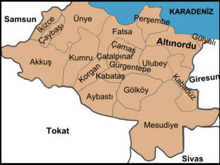
Giresun, formerly Cerasus, is a city in the Black Sea Region of northeastern Turkey, about 175 km (109 mi) west of the city of Trabzon. It is the seat of Giresun Province and Giresun District. It has a population of 125,682 (2022).

Gümüşhane is a city in the Black Sea Region of Turkey. It is the seat of Gümüşhane Province and Gümüşhane District. Its population is 39,214 (2022). The city lies along the Harşit River, about 40 miles (64 km) southwest of Trabzon. The city lies at an elevation of 1,153 m (3,783 ft).

Bulancak is a town in Giresun Province on the Black Sea coast of Turkey, near the city of Giresun. Its former name is Terastios. It is the seat of Bulancak District. Its population is 49,053 (2022).

Dereli is a town in Giresun Province in the Black Sea region of Turkey. It is the seat of Dereli District. Its population is 5,879 (2022). The mayor is Kazım Zeki Şenlikoğlu (AKP).
Espiye is a town in Giresun Province in the Black Sea region of Turkey. It is the seat of Espiye District. Its population is 26,671 (2022).

Görele is a town in Giresun Province on the Black Sea coast of eastern Turkey. It is the seat of Görele District. Its population is 18,725 (2022).
Tirebolu, is a town in Giresun Province, Turkey. It is the seat of Tirebolu District. Its population is 20,671 (2022).

Akçaabat is a municipality and district of Trabzon Province, Turkey. Its area is 375 km2, and its population is 129,290 (2022). It lies on the Black Sea coast, to the west of the city of Trabzon. Its elevation is ten metres (33 ft). Akçaabat is a coastal town known for its local soccer team Akçaabat Sebatspor, its kofta dish Akçaabat köfte and the Akçaabat Horonu dance. Akçaabat has hosted an international folklore festival since 1990, and it was a venue for Archery and Athletics competitions of the First Black Sea Games held in 2007.
Perşembe is a municipality and district of Ordu Province, Turkey. Its area is 217 km2, and its population is 30,101 (2022). The town lies on the Black Sea coast at an elevation of 20 m (66 ft).

Çarşıbaşı is a municipality and district of Trabzon Province, Turkey. Its area is 66 km2, and its population is 15,227 (2022). On 31 March 2024, Ahmet Keleş (MHP) was elected mayor. Çarşıbaşı is 34 km from Giresun, on the west coastal road. Its old name being “İskefiye”, Çarşıbaşı revised their name in 1962. Çarşıbaşı was also called “Pazaronu,” as it was the main place to stay for those traveling to the famous marketplace in Vakfıkebir.

Şebinkarahisar is a town in Giresun Province in the Black Sea region of northeastern Turkey. It is the administrative seat of Şebinkarahisar District. Its population is 10,695 (2022).

The Republic of Pontus was a proposed Pontic Greek state on the southern coast of the Black Sea. Its territory would have encompassed much of historical Pontus in north-eastern Asia Minor, and today forms part of Turkey's Black Sea Region. The proposed state was discussed at the Paris Peace Conference of 1919, but the Greek government of Eleftherios Venizelos feared the precarious position of such a state and so it was included instead in the larger proposed state of Wilsonian Armenia. Ultimately, however, neither state came into existence and the Pontic Greek population was massacred and expelled from Turkey after 1922 and resettled in the Soviet Union or in Macedonia, Greece. This state of affairs was later formally recognized as part of the population exchange between Greece and Turkey in 1923. In modern Greek political circles, the exchange is seen as inextricable from the contemporaneous Greek genocide.
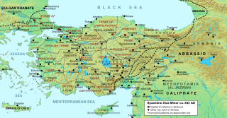
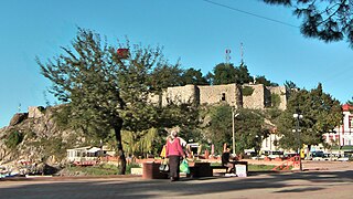
Chaldia was a historical region located in the mountainous interior of the eastern Black Sea, northeast Anatolia. Its name was derived from a people called the Chaldoi that inhabited the region in antiquity. Chaldia was used throughout the Byzantine period and was established as a formal theme, known as the Theme of Chaldia, by 840. During the Late Middle Ages, it formed the core of the Empire of Trebizond until its fall to the Ottoman Empire in 1461.

Chepni is one of the 24 Oghuz Turkic tribes.
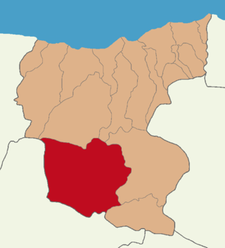
Şebinkarahisar District is a district of Giresun Province in northeastern Turkey. Its administrative seat is the town of Şebinkarahisar. Its area is 1,396 km2, and its population is 19,625 (2022). It is inland from the Black Sea in the Giresun Mountains.
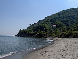
Coralla or Koralla was a town of ancient Pontus on a cape of the same name. It is placed by Arrian, and the anonymous author of the Periplus, 100 stadia east of Philocaleia, and Philocaleia is 110 stadia east of Tripolis, a well-known position.