Yalova Province is a province in northwestern Turkey, on the eastern coast of the Sea of Marmara. Its adjacent provinces are Bursa to the south and Kocaeli to the east. The provincial capital is the city of Yalova. The population of the Yalova Province was 203,741 in 2010. Prior to 1930, the area around Yalova constituted a district of Kocaeli Province; from 1930 to 1995, it was made part of Istanbul Province; in 1995, the area was separated and made into the current Yalova Province.

The Mangapps Railway Museum is a heritage railway centre located near Burnham-on-Crouch in Essex. The 0.75 miles (1.21 km) of standard gauge running line and museum are owned and operated by the Jolly family assisted by volunteers.
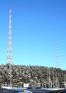
The Lahti longwave transmitter was a facility for longwave transmission at Lahti, Finland on 252KHz. It was inaugurated in 1927 and used a T-type aerial strung between two 150 metre high free standing steel framework towers. The Lahti longwave transmitter was shut down in 1993. Nowadays the facility is used as a museum. The red-and-white towers are still standing and form a local landmark. Nearby is lake Mytäjäinen.

Utena District Municipality is one of 60 municipalities in Lithuania.

Kreillerstraße is a Munich U-Bahn station on line U2.
Glen is a small village in County Donegal, Ireland. The focus of the townlands of Glenmenagh and Glenineeny, it is within the parish of Mevagh, and the Barony of Kilmacrenan. The village is on the crossroads between the towns of Milford, Letterkenny, Creeslough, and Carrigart. The village once supported a schoolhouse, post office and shop, as well as historically a fair. Today however, one of the few businesses left is the historic local public house, originally a shebeen and dating from the 17th century.

Linwood is an unincorporated community in Lafayette Township, Madison County, Indiana.
Dobki is a village in the administrative district of Gmina Tykocin, within Białystok County, Podlaskie Voivodeship, in north-eastern Poland.

Jaczno is a village in the administrative district of Gmina Dąbrowa Białostocka, within Sokółka County, Podlaskie Voivodeship, in north-eastern Poland. It lies approximately 6 kilometres (4 mi) east of Dąbrowa Białostocka, 28 km (17 mi) north of Sokółka, and 62 km (39 mi) north of the regional capital Białystok.

Lazılar is a village in the Tovuz Rayon of Azerbaijan. The village forms part of the municipality of Ağbaşlar.
İsgəndərbəyli is a village in the Zangilan Rayon of Azerbaijan.
Wielka Wieś is a village in the administrative district of Gmina Stąporków, within Końskie County, Świętokrzyskie Voivodeship, in south-central Poland. It lies approximately 6 kilometres (4 mi) north-east of Stąporków, 13 km (8 mi) east of Końskie, and 35 km (22 mi) north of the regional capital Kielce.
Honghuagang District is a district of the city of Zunyi, Guizhou province, China. It is under the administration of Zunyi city. Its population as of 2002 was 470,000.
El Guedid is a town and commune in Djelfa Province, Algeria. According to the 1998 census it has a population of 11,059.
Raouraoua is a town and commune in Bouïra Province, Algeria. According to the 1998 census it has a population of 7,209.
Chihani is a town and commune in El Taref Province, Algeria. According to the 1998 census it has a population of 9,234.
Highway 65 or Route 65, popularly known as the Qassim Highway is a major highway of central Saudi Arabia. It connects the capital of Riyadh to Buraidah, Ha'il and finally Sakakah in the northwest, and Al-Kharj in the southeast, and lasts for approximately 1200 kilometres. The highway begins at Kharj, and goes through Riyadh, where it intersects Highway 40, at the junction between Highway 40 and Highway 505 in at 24°45′40″N46°38′49″E. After Riyadh, it heads towards Al-Qassim Province, linking Highway 60 at Buraydah, Highway 389/ Highway 70 at Ha'il at 27°29′59″N41°41′54″E, and ends after Qurayyat at the Jordanian border.

Highway 40 is the most important highway of Saudi Arabia, linking the largest cities by crossing the entire country and Arabian Peninsula. The 1,359 km highway connects Jeddah and Mecca on the west coast to Dammam on the east coast, passing through the capital of Riyadh on the way where it intersects with Highway 65, another of Saudi Arabia's most important road links in the centre of the country at 24°45′40″N46°38′49″E. The highway begins at Jeddah at 21°26′56″N39°15′32″E linking with Highway 5 and ends in Dammam at 26°21′9″N50°1′55″E.

Airport East station is the elevated terminus station on Line 1 of the Shenzhen Metro in Shenzhen, Guangdong Province, China. The station opened on 15 June 2011. Over 80,000 people per day use the station.

Mostra is an underground metro station that serve Line 6 on the Naples Metro.