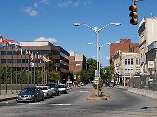
Fall River is a city in Bristol County, Massachusetts, United States. Fall River's population was 94,000 at the 2020 United States census, making it the tenth-largest city in the state.

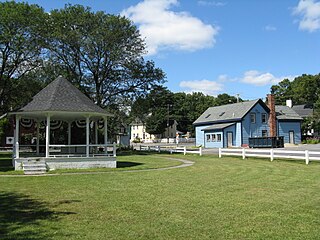
Freetown is a town in Bristol County, Massachusetts, United States. The population was 9,206 at the 2020 census.

Tiverton is a town in Newport County, Rhode Island, United States. The population was 16,359 at the 2020 census.

The Taunton River, historically also called the Taunton Great River, is a river in southeastern Massachusetts in the United States. It arises from the confluence of the Town River and Matfield River, in the town of Bridgewater. From there it meanders through the towns of Halifax, Middleborough and Raynham, through the city of Taunton for which it is named, the towns of Berkley, Dighton, Somerset, and the Assonet section of Freetown, to Fall River where it joins Mount Hope Bay, an arm of Narragansett Bay.
Assonet is one of two villages in the town of Freetown, Massachusetts in Bristol County, Massachusetts, United States. An original part of the town, Assonet was settled in 1659 along with the city of Fall River, then a part of Freetown. It rests on the banks of the Assonet River. As of the 2000 census, the village had a total population of 4,084; up from 3,614 in 1990. As of the 2014 census the village had a total estimated population of 9,093.
The Narragansett Council of the Boy Scouts of America serves all of the state of Rhode Island and some of Massachusetts and Connecticut. Its several camps include Camp Yawgoog, Champlin Scout Reservation, and Camp Norse.

Scouting in Rhode Island has a long history, from the 1910s to the present day, serving thousands of youth in programs that suit the environment in which they live.

The Mount Hope Bay raids were a series of military raids conducted by British troops during the American Revolutionary War against communities on the shores of Mount Hope Bay on May 25 and 31, 1778. The towns of Bristol and Warren, Rhode Island were significantly damaged, and Freetown, Massachusetts was also attacked, although its militia resisted British attacks more successfully. The British destroyed military defenses in the area, including supplies that had been cached by the Continental Army in anticipation of an assault on British-occupied Newport, Rhode Island. Homes as well as municipal and religious buildings were also destroyed in the raids.

Chateau-sur-Mer is one of the first grand Bellevue Avenue mansions of the Gilded Age in Newport, Rhode Island. Located at 474 Bellevue Avenue, it is now owned by the Preservation Society of Newport County and is open to the public as a museum. Chateau-sur-Mer's grand scale and lavish parties ushered in the Gilded Age of Newport, as it was the most palatial residence in Newport until the Vanderbilt houses in the 1890s. It was designated a National Historic Landmark in 2006.

The Freetown-Fall River State Forest is a publicly owned forest covering more than 5,000 acres (2,000 ha) in the city of Fall River and the towns of Freetown and Lakeville in the state of Massachusetts. The forest lies mostly in the center of the town of Freetown dividing Assonet, East Freetown, and Fall River's northernmost boundary. The forest land includes Profile Rock, a granite outcropping which local Native Americans believe to be the image of Chief Massasoit, and a 227-acre (92 ha) Wampanoag reservation. The forest is owned by the Commonwealth of Massachusetts and operated by the Department of Conservation and Recreation with headquarters in Assonet.

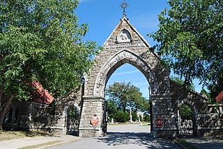
Oak Grove Cemetery is a historic cemetery located at 765 Prospect Street in Fall River, Massachusetts. It was established in 1855 and greatly improved upon in the years that followed. It features Gothic Revival elements, including an elaborate entrance arch constructed of locally quarried Fall River granite. The cemetery originally contained 47 acres, but has since been expanded to over 120 acres. The cemetery is the city's most significant, built in the planned rural-garden style of Mount Auburn Cemetery in Cambridge, Massachusetts. It was designed and laid out by local architect Josiah Brown, who is also known for his designs of early mills including the Union, Border City, and others.

For much of its history, the city of Fall River, Massachusetts has been defined by the rise and fall of its cotton textile industry. From its beginnings as a rural outpost of the Plymouth Colony, the city grew to become the largest textile producing center in the United States during the 19th century, with over one hundred mills in operation by 1920. Even with the demise of local textile productions during the 20th century, there remains a lasting legacy of its impact on the city.

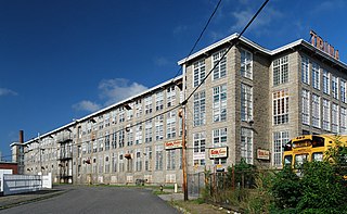
Narragansett Mills is a historic textile mill site located at 1567 North Main Street in Fall River, Massachusetts, United States. Built in 1872, it is a well-preserved example of a brick mill complex, somewhat unusual in a city where most of the mills are stone. It was listed on the National Register of Historic Places in 1983.
Sagamore Mills No. 1 and No. 3 are two historic textile mills on Ace Street in Fall River, Massachusetts. Built in 1888 and 1908, they form part of one of the city's single largest textile operations of the late 19th century. Mills No. 1 and 3 were added to the National Register of Historic Places in 1983, with a separate listing for Mill No. 2, located nearby on North Main Street.

Sagamore Mill No. 2 is an historic textile mill located at 1822 N. Main Street in Fall River, Massachusetts. Built in 1881, it is the oldest surviving mill of three built by the Sagamore Mill Company, one of Fall River's largest textile operations. The mill complex was added to the National Register of Historic Places in 1983.
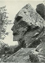
Profile Rock was a 50-foot high granite rock formation located in Freetown, Massachusetts just outside Assonet village and near the Freetown State Forest. Local Wampanoags believe it to be the image of Chief Massasoit. The Wampanoags occupied the region of Rhode Island and Massachusetts bounded by Narragansett Bay to the west and the Atlantic Ocean to the east, and Chief Massasoit was a close friend to the early Pilgrim settlers.
The Assonet Burying Ground is the main public cemetery for Freetown, Massachusetts.

The geology of Massachusetts includes numerous units of volcanic, intrusive igneous, metamorphic and sedimentary rocks formed within the last 1.2 billion years. The oldest formations are gneiss rocks in the Berkshires, which were metamorphosed from older rocks during the Proterozoic Grenville orogeny as the proto-North American continent Laurentia collided against proto-South America. Throughout the Paleozoic, overlapping the rapid diversification of multi-cellular life, a series of six island arcs collided with the Laurentian continental margin. Also termed continental terranes, these sections of continental rock typically formed offshore or onshore of the proto-African continent Gondwana and in many cases had experienced volcanic events and faulting before joining the Laurentian continent. These sequential collisions metamorphosed new rocks from sediments, created uplands and faults and resulted in widespread volcanic activity. Simultaneously, the collisions raised the Appalachian Mountains to the height of the current day Himalayas.

The geology of Rhode Island is based on nearly one billion year old igneous crystalline basement rocks formed as part of the microcontinent Avalonia that collided with the supercontinent Gondwana. The region experienced substantial folding associated with its landlocked position during the Alleghanian orogeny mountain building event. The region accumulated sedimentary rocks, including small deposits of coal. The region was covered with thick Atlantic Coastal Plain sediments, with the erosion of the Appalachians and the creation of the Atlantic Ocean throughout the past 200 million years. These surficial sediments and soils were substantially reworked by the Pleistocene glaciations. The state's geology is part of the broader geology of New England.


