Downtown Fall River Historic District

Last updated
Downtown Fall River Historic District

Bank Street Fall River.jpg

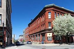
Bank Street, Downtown Fall River
USA Massachusetts location map.svg
Red pog.svg
Usa edcp location map.svg
Red pog.svg
Location Fall River, Massachusetts
Coordinates 41°42′11″N71°9′21″W / 41.70306°N 71.15583°W / 41.70306; -71.15583 Coordinates: 41°42′11″N71°9′21″W / 41.70306°N 71.15583°W / 41.70306; -71.15583
Built 1845
Architectural style Late 19th And 20th Century Revivals, Late Victorian
MPS Fall River MRA
NRHP reference #

83000662

[1]
Added to NRHP February 16, 1983
Bank Street Armory Bank Street Armory.jpg
Bank Street Armory
North Main Street North Main St FR.jpg
North Main Street
Bedford Street Bedford Street FR.jpg
Bedford Street

Downtown Fall River Historic District is a historic district on North and South Main, Bedford, Granite, Bank, Franklin, and Elm Streets in Fall River, Massachusetts.

Fall River, Massachusetts City in Massachusetts, United States

Fall River is a city in Bristol County, Massachusetts, United States. The City of Fall River is located approximately 53 miles (85 km) south of Boston, 17 miles (27 km) southeast of Providence, Rhode Island, 20 miles (32 km) south of Taunton, 12 miles (19 km) west of New Bedford, 20 miles (32 km) north of Newport, Rhode Island, and 200 miles (320 km) northeast of New York City. The City of Fall River's population was 87,103 at the 2010 census, making it the tenth-largest city in the state.

Contents

The district was added to the National Register of Historic Places in 1983.

National Register of Historic Places federal list of historic sites in the United States

The National Register of Historic Places (NRHP) is the United States federal government's official list of districts, sites, buildings, structures, and objects deemed worthy of preservation for their historical significance. A property listed in the National Register, or located within a National Register Historic District, may qualify for tax incentives derived from the total value of expenses incurred preserving the property.

History

The Downtown Fall River Historic District contains many historic banks and other commercial properties primarily along North Main Street. This area was greatly impacted by the Great Fire of 1928, which destroyed many buildings located in what is now the historic district. [2] As a result, many of the buildings date from about 1928 or 1929, having been rebuilt shortly after the fire. The area was also greatly impacted in the 1960s with the construction of Interstate-195 through the center of downtown, which resulted in the demolition of the Old City Hall, the Second Granite Block and several other 19th century commercial blocks.

Contributing properties

(partial listing)

See also

List of Registered Historic Places in Fall River, Massachusetts, which has been transferred from and is an integral part of National Register of Historic Places listings in Bristol County, Massachusetts

Related Research Articles

Quequechan River river in the United States of America

The Quequechan River is a river in Fall River, Massachusetts, that flows in a northwesterly direction from the northwest corner of the South Watuppa Pond through the heart of the city of Fall River and into the end of the Taunton River at Mount Hope Bay at Heritage State Park/Battleship Cove. The word Quequechan means "Falling River" or "Leaping/Falling Waters" in Wampanoag, hence the city's name.

Downtown Stamford human settlement in United States of America

Downtown Stamford is the central business district of the city of Stamford, Connecticut, United States. Also known as "Stamford Downtown". It includes major retail establishments, a shopping mall, a university campus, the headquarters of major corporations and fortune 500 companies, as well as other retail businesses, hotels, restaurants, offices, entertainment venues, and high-rise apartment buildings.

Willimantic Footbridge

The Willimantic Footbridge is a pedestrian bridge in the Willimantic section of Windham, Connecticut. Built in 1906, it extends from Main Street southward, across Riverside Drive, railroad tracks, and the Willimantic River, connecting downtown Willimantic to the residential area south of the river. It is one of a small number of pedestrian bridges built in the early 20th century to survive in the state. It was listed on the National Register of Historic Places in 1979.

Ayer Main Street Historic District

The Ayer Main Street Historic District encompasses most of the historic central business district of Ayer, Massachusetts. It extends along Main Street between Park and Columbia Streets, and was mostly developed between 1872 and 1898 as a hub of railroad and roadway-based economic activity. The district was listed on the National Register of Historic Places in 1989.

Lower Highlands Historic District

The Lower Highlands Historic District encompasses one of the oldest residential areas of Fall River, Massachusetts. The district is roughly bounded by Cherry, Main, Winter, and Bank Streets, and is located just east of the Downtown Fall River Historic District and directly south of the Highlands Historic District. This area was settled by 1810, has architecture tracing the city's growth as a major industrial center. The historic district was added to the National Register of Historic Places in 1984.

Central New Bedford Historic District

The Central New Bedford Historic District is one of nine historic districts in New Bedford, Massachusetts, United States. The district encompasses the city's central business district, built up during the time in the late 19th century when textiles had replaced whaling as the city's main industry. It is a 29-acre (12 ha) rectangular area bounded by Acushnet Avenue and the older New Bedford Historic District on the east, School Street to the south, Middle Street on the north and 6th Street in the west. It was added to the National Register of Historic Places in 1980.

Pilgrim Mills

Pilgrim Mills is an historic textile mill located at 847 Pleasant Street in Fall River, Massachusetts. The mill was built in 1911 from red brick and was the first mill in the city powered entirely by electricity, provided from the local grid. It was one of the last mill complexes built in the city. The property was listed on the National Register of Historic Places in 1983.

Fall River Waterworks

Fall River Waterworks is a 22-acre (8.9 ha) historic site located at the eastern end Bedford Street in Fall River, Massachusetts, along the shore of North Watuppa Pond. The property, which is still used as a water works for the city, contains the original pumping station, intake house and 121-foot (37 m) tall standpipe water tower. The system was originally built between 1872 and 1875, and expanded or upgraded many times. It was added to the National Register of Historic Places in 1981.

Main Street Historic District (Greenfield, Massachusetts)

The Main Street Historic District encompasses the civic core of Greenfield, Massachusetts, the county seat of Franklin County, Massachusetts. The district includes several blocks of Main Street extending roughly from Chapman Street in the west to Franklin Street in the east, as well as a number of properties facing the common along Bank Row, south of Main Street, and is architecture reflective of the city's 19th-century growth as a major crossroads and county seat. The district includes the town hall, county courthouse, several 19th century bank buildings, and three properties previously listed on the National Register of Historic Places: the Garden Theater Block, the Leavitt-Hovey House, and the 1915 Post Office building. The district was listed on the National Register of Historic Places in 1988.

Central Gloucester Historic District

The Central Gloucester Historic District encompasses the historic commercial, civic, and residential core of the fishing community of Gloucester, Massachusetts. Now largely defined by 19th century architectural trends, it includes the city's commercial downtown, its civic heart on Dale and Prospect Streets, and some adjacent residential areas. It was added to the National Register of Historic Places in 1982.

Central Square Historic District (Waltham, Massachusetts)

The Central Square Historic District is a historic district encompassing the central town common of the city of Waltham, Massachusetts, and several commercial buildings facing the common or in its immediate vicinity. The common is bounded by Carter, Moody, Main, and Elm Streets; the district includes fourteen buildings, which are located on Main, Elm, Lexington, and Church Streets, on the north and east side of the common. The district was listed on the National Register of Historic Places in 1989.

Mechanics Hall District

The Mechanics' Hall District is a historic district encompassing a city block of downtown Worcester, Massachusetts that preserves its late 19th-century appearance. Itis located on Main Street between Exchange and Foster Streets, including both the Worcester Five Cents Savings Bank building and Mechanics Hall. It was added to the National Register of Historic Places in 1980.

District A

District A is a historic worker housing district located in Manchester, New Hampshire, near the former Amoskeag Manufacturing Company millyard. It is bounded by Pleasant, State, Granite, and Bedford streets, and includes seven surviving tenement blocks built by Amoskeag between 1843 and 1852. The district was added to the National Register of Historic Places on November 12, 1982.

North Main–Bank Streets Historic District

The North Main–Bank Streets Historic District is located along those streets in Albion, New York, United States. It is one of two historic districts in the village, comprising the commercial core of the village, developed during its years as a major stop on the Erie Canal. A portion of the canal, now the New York State Barge Canal, and two of its bridges are within the district.

Great Fall River fire of 1928

The Great Fall River fire of 1928 occurred on February 2–3, 1928 and destroyed a vast portion of downtown Fall River, Massachusetts. Although the city has had many other large fires, both before and after, the 1928 conflagration is generally considered the worst in the city's history, since it destroyed so many businesses at a time when the city's economy was already struggling from recent textile plant closings. By the time the fire was out, five city blocks were completely wiped out. Nobody was killed and only a few people suffered serious injuries.

Helena Historic District (Helena, Montana) historic district in Helena, Montana

The Helena Historic District (HHD) is a federally designated historic district in Helena, Montana, United States. Since its establishment in 1972, the HHD has had boundary adjustments in 1990 and 1993. The original 1972 designation was composed of two unconnected sections known as "Downtown" and "West Residential".

Biddeford Main Street Historic District

Biddeford Main Street Historic District is an historic district in downtown Biddeford, Maine. It encompasses the heart of the city's civic and commercial business district, extending along Main and Water Streets between Pike and Elm Streets, extending for short distances along several side streets. It is noted for its collection of late 19th and early 20th century commercial brick and masonry architecture. The district was added to the National Register of Historic Places in 2009.

Waterville Main Street Historic District building in Maine, United States

The Waterville Main Street Historic District encompasses the best-preserved portions of the historical commercial downtown area of Waterville, Maine. Developed most intensively in the late 19th and early 20th centuries, this area was the center of commerce for Waterville and the surrounding rural communities. It encompasses 25 properties on Main and Common Streets, including the Waterville Opera House and City Hall. It was listed on the National Register of Historic Places in 2012, and was slightly enlarged in 2016.

Downtown Richford Historic District

The Downtown Richford Historic District encompasses a cluster of commercial and industrial buildings at the center of Richford, Vermont. Centered on the junction of Main and River Streets are a cluster of mainly brick buildings, built between 1880 and 1920, with several industrial properties just across the Missisquoi River to the south, whose waters provided the power for the industries that fueled the town's growth. The district was listed on the National Register of Historic Places in 1980.

Downtown Hardwick Village Historic District

The Downtown Hardwick Village Historic District encompasses a significant portion of the downtown area of Hardwick, Vermont. The town developed in the 19th century first as a small industrial center, and later became one of the world's leading processors of granite. The district was listed on the National Register of Historic Places in 1982.

References