
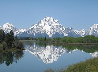
Mount Moran is a mountain in Grand Teton National Park of western Wyoming, USA. The mountain is named for Thomas Moran, an American western frontier landscape artist. Mount Moran dominates the northern section of the Teton Range rising 6,000 feet (1,800 m) above Jackson Lake. Several active glaciers exist on the mountain with Skillet Glacier plainly visible on the monolithic east face. Like the Middle Teton in the same range, Mount Moran's face is marked by a distinctive basalt intrusion known as the Black Dike.

Schoolroom Glacier is a small glacier in Grand Teton National Park in the U.S. state of Wyoming. This Teton Range glacier lies adjacent to the south Cascade Canyon trail at an altitude of 10,400 ft (3,200 m), approximately 12 mi (19 km) from the trailhead at Jenny Lake. The glacier has many of the classic textbook details of a glacier, namely, well defined terminal and lateral moraines, crevasses, a proglacial lake and related features which led to the naming schoolroom.

Bivouac Peak is in the northern Teton Range, Grand Teton National Park, Wyoming. The peak is located immediately to the west of Moran Bay on Jackson Lake, and rises more than 4,000 ft (1,200 m) in less than 0.5 mi (0.80 km) from the lakeshore. Moran Canyon is situated to the south of the mountain and Snowshoe Canyon lies to the north.

Thor Peak is in the northern Teton Range, Grand Teton National Park, in the U.S. state of Wyoming. Mount Moran is 1 mile (1.6 km) to the east. The summit is the eighth-highest in the Teton Range. Several semi-permanent snowfields as well as the Triple Glaciers are located on the east and northern slopes of the mountain. While the easiest route up the mountain, the south slope, is only rated a class 4, the mountain's remoteness and difficulty of approach make it a challenging mountain to summit.

Mount Woodring is located in the Teton Range, Grand Teton National Park, Wyoming. The mountain is immediately west of Leigh Lake and is sandwiched between Paintbrush Canyon to the south and Leigh Canyon to the north. The best access to the summit is from Paintbrush Divide along the Paintbrush Canyon Trail.

Middle Teton Glacier is on the northeast flank of Middle Teton in Grand Teton National Park, Wyoming. The alpine glacier is a popular mountaineering route for ice climbing and for access to the summit of Middle Teton and other peaks to the south. The glacier is at the west end of Garnet Canyon, which is the most popular route used by climbers ascending Grand Teton. The glacier melt feeds streams below including Spalding Falls, an 80 ft (24 m) high cascade. Between 1967 and 2006, Middle Teton Glacier lost approximately 25 percent of its surface area, shrinking from 52 to 39 acres.

Teton Glacier is a mountain glacier located below the north face of Grand Teton in Grand Teton National Park, Wyoming, United States. Its neighbors are Mount Owen to the west and Teewinot Mountain 12,330 feet (3,758 m) to the north.
Teepe Glacier is below the northeast face of Teepe Pillar in Grand Teton National Park, Wyoming, United States. The glacier is immediately southeast of Grand Teton in the heart of the Cathedral Group collection of high peaks in the Teton Range. Between 1967 and 2006, Teepe Glacier lost approximately 60 percent of its surface area, shrinking from 13 to 5 acres.

Skillet Glacier is in Grand Teton National Park, Wyoming, United States. The glacier is situated on the eastern cliffs of Mount Moran and is easily seen from Jackson Hole. The shape of the glacier led to the naming as the uppermost section of the glacier is long and narrow and then broadens abruptly more than halfway down the mountain into a larger area, giving it the shape of a skillet or frying pan. The glacier is one of twelve that remain in Grand Teton National Park and one of five glaciers located on Mount Moran. Mountain climbers consider the Skillet Glacier route to be the fastest and one of the easiest ways to climb Mount Moran, and was the route taken when the peak was first climbed in 1922, though it is rarely used in late summer due to poor footing. On November 21, 1950, A DC-3 crashed into Mount Moran, adjacent to Skillet Glacier, killing all 21 passengers aboard. The remains of the passengers and the plane are still on the mountain.
Triple Glaciers are in Grand Teton National Park, Wyoming, United States. The glaciers are disconnected from each other and occupy three separate cirques on the northwest face of Mount Moran and northeast of Thor Peak. The glaciers are unofficially referred to as East, Middle and West Triple Glacier.

Petersen Glacier is in Grand Teton National Park, Wyoming, United States. The glacier is in a cirque to the west and above north Cascade Canyon at an altitude of approximately 10,000 feet (3,000 m). The glacier is named after Frank Petersen, one of the first mountaineers to climb Grand Teton in 1898. Runoff from the glacier is heavy in rock flour which turns the waters of Mica Lake turquoise in appearance. The glacier is no longer visible in satellite imagery, indicating it may have disappeared. All of the existing glaciers in Grand Teton National Park were created during the Little Ice Age (1350-1850) and have been in a general state of retreat since the mid-19th century.

Paintbrush Canyon is located in Grand Teton National Park, in the U. S. state of Wyoming. The canyon was formed by glaciers which retreated at the end of the last glacial maximum approximately 15,000 years ago. The canyon lies between Rockchuck Peak and Mount Saint John to the south and Mount Woodring to the north. Leigh Lake is at the base of the canyon to the east and the alpine Holly Lake is located mid canyon. Popular with hikers, the canyon is part of a popular circuit hike of 19.2 miles (30.9 km) which is rated as very strenuous and includes a total elevation change of 3,845 feet (1,172 m) due to the ascent to Paintbrush Divide 10,720 feet (3,270 m). Views from Paintbrush Divide include Lake Solitude and of Mount Moran to the north and the Cathedral Group including Grand Teton to the south. An ice axe may be necessary for hikes in the early summer. The Paintbrush Canyon Trail is part of the Teton Crest Trail, which spans the southern section of the Teton Range from Teton Pass along Wyoming Highway 22 to String Lake, a total distance of 39 miles (63 km).
Moran Canyon is located in Grand Teton National Park, in the U. S. state of Wyoming. The canyon lies between Mount Moran to the south and Traverse Peak and Bivouac Peak to the north. Moran Bay, part of Jackson Lake, is at the mouth of the canyon to the east. The canyon was formed by glaciers which retreated at the end of the last glacial maximum approximately 15,000 years ago.
The canyons of the Teton Range lie almost entirely within Grand Teton National Park in the U.S. state of Wyoming. Ranging from 9 miles (14 km) to less than 1 mile (1.6 km) in length and up to 6,000 feet (1,800 m) deep, the canyons were carved primarily by glaciers over the past 250,000 years. The canyons in the Teton Range descend in altitude generally west to east and many have lakes at their outlets. The lakes were created by terminal moraines left behind by the now retreated glaciers. A few of the canyons have small glaciers that were created mostly during the Little Ice Age (1550-1850). Fast retreating Schoolroom Glacier is a tiny glacier located at the head of the South Cascade Canyon. Most of the canyons have streams from which rain and snowmelt flow towards Jackson Hole valley, and due to the sometimes rapid altitude descent, waterfalls are common. The canyons offer the easiest hiking access into the Teton Range.
Leigh Canyon is located in Grand Teton National Park, in the U. S. state of Wyoming. The canyon was formed by glaciers which retreated at the end of the last glacial maximum approximately 15,000 years ago, leaving behind a U-shaped valley. Leigh Canyon is approximately 6 miles (9.7 km) long and is flanked by Mount Moran and Thor Peak to the north and Mount Woodring to the south. The canyon outlet is at Leigh Lake and at the head of the canyon lies Mink Lake.

Hanging Canyon is located in Grand Teton National Park, in the U. S. state of Wyoming. The canyon was formed by glaciers which retreated at the end of the last glacial maximum approximately 15,000 years ago, leaving behind a U-shaped valley. Hanging Canyon is south of Mount Saint John and north of Symmetry Spire. The canyon is northwest of Jenny Lake and within the canyon lies Lake of the Crags, Ramshead Lake and Arrowhead Pool.
Window Peak is located in the Teton Range, Grand Teton National Park in the U.S. state of Wyoming. The peak is in the western reaches of Moran Canyon.
Maidenform Peak (11,142 feet is located in the Teton Range, Grand Teton National Park in the U.S. state of Wyoming. Maidenform Peak is at the head of Leigh Canyon and .64 miles SSW of Cleaver Peak. Cirque Lake is immediately east of the peak.
Bearpaw Lake is located in Grand Teton National Park, in the U. S. state of Wyoming. Bearpaw Lake is south of Trapper Lake and north of Leigh Lake. Bearpaw Lake is an easy to moderate 9.2-mile (14.8 km) round trip hike along the Leigh Lake Trail. The trail starts at the String Lake trailhead and wanders north along the east shores of Leigh Lake with a 460 feet (140 m) elevation gain. Bearpaw Lake is nestled at the eastern base of Mount Moran and snow and glacier meltwaters off Skillet Glacier eventually feed into the lake. There are three backcountry camping sites with designated tent pads at the lake and a backcountry permit is required to use these sites.
The following articles relate to the history, geography, geology, flora, fauna, structures and recreation in Grand Teton National Park.

