Famara is the main mountainous massif in the north of the island of Lanzarote in the Canary Islands. It is the eastern slope of a volcano erupting in the Miocene. The cliffs of Famara (Risco de Famara) are the remains of a caldera of about ten kilometres in diameter centred on the south of La Graciosa.[1]
The beach south of the cliffs of Famara, the Playa de Famara, is one of sand and volcanic pebbles. It is two kilometres long. Its orientation towards the Atlantic Ocean makes it suitable for the practice of surfing.[2]
A popular seaside resort, Caleta de Famara, has been built here. It is part of the Teguise municipality.
Environment
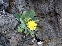
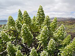
The coast north of Famara beach is closed by cliffs and inaccessible to vehicles. It is a remarkable biodiversity site, with about ten species of endemic plants at the site.[3]
All the cliffs of Famara and its coastline are integrated into the natural park of the Chinijo Archipelago.
Endemic plants
There are about ten species of endemic plants on the coastal plain at the foot of the Famara cliffs. This endemism has been fostered by isolation dating back more than a million years.
Kunkel, Günther W.H. (1982). Los Riscos de Famara (Lanzarote, Islas Canarias): Breve descripción y guía florística. Naturalia Hispanica (in Spanish). Madrid: Instituto nacional para la conservacion de la naturaleza. p.118.
This page is based on this Wikipedia article Text is available under the CC BY-SA 4.0 license; additional terms may apply. Images, videos and audio are available under their respective licenses.