Related Research Articles
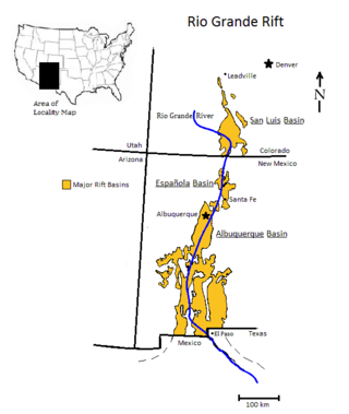
The Rio Grande rift is a north-trending continental rift zone. It separates the Colorado Plateau in the west from the interior of the North American craton on the east. The rift extends from central Colorado in the north to the state of Chihuahua, Mexico, in the south. The rift zone consists of four basins that have an average width of 50 kilometres (31 mi). The rift can be observed on location at Rio Grande National Forest, White Sands National Park, Santa Fe National Forest, and Cibola National Forest, among other locations.
A transform fault or transform boundary, is a fault along a plate boundary where the motion is predominantly horizontal. It ends abruptly where it connects to another plate boundary, either another transform, a spreading ridge, or a subduction zone. A transform fault is a special case of a strike-slip fault that also forms a plate boundary.

The Basin and Range Province is a vast physiographic region covering much of the inland Western United States and northwestern Mexico. It is defined by unique basin and range topography, characterized by abrupt changes in elevation, alternating between narrow faulted mountain chains and flat arid valleys or basins. The physiography of the province is the result of tectonic extension that began around 17 million years ago in the early Miocene epoch.
In geology, the slab gap hypothesis is one of the explanations put forward to explain several instances of crustal extension that occur inland near former subduction zones.

The North American Plate is a tectonic plate containing most of North America, Cuba, the Bahamas, extreme northeastern Asia, and parts of Iceland and the Azores. With an area of 76 million km2 (29 million sq mi), it is the Earth's second largest tectonic plate, behind the Pacific Plate.

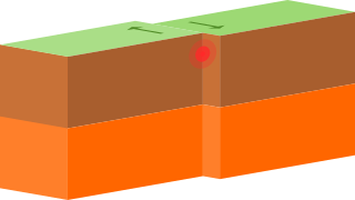
In geology, a rift is a linear zone where the lithosphere is being pulled apart and is an example of extensional tectonics. Typical rift features are a central linear downfaulted depression, called a graben, or more commonly a half-graben with normal faulting and rift-flank uplifts mainly on one side. Where rifts remain above sea level they form a rift valley, which may be filled by water forming a rift lake. The axis of the rift area may contain volcanic rocks, and active volcanism is a part of many, but not all, active rift systems.
The East Pacific Rise (EPR) is a mid-ocean rise, at a divergent tectonic plate boundary, located along the floor of the Pacific Ocean. It separates the Pacific Plate to the west from the North American Plate, the Rivera Plate, the Cocos Plate, the Nazca Plate, and the Antarctic Plate. It runs south from the Gulf of California in the Salton Sea basin in Southern California to a point near 55°S130°W, where it joins the Pacific-Antarctic Ridge (PAR) trending west-south-west towards Antarctica, near New Zealand. Much of the rise lies about 3,200 km (2,000 mi) off the South American coast and reaches a height about 1,800–2,700 m (5,900–8,900 ft) above the surrounding seafloor.
In hydrology, an oceanic basin (or ocean basin) is anywhere on Earth that is covered by seawater. Geologically, most of the ocean basins are large geologic basins that are below sea level.

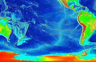
A mid-ocean ridge (MOR) is a seafloor mountain system formed by plate tectonics. It typically has a depth of about 2,600 meters (8,500 ft) and rises about 2,000 meters (6,600 ft) above the deepest portion of an ocean basin. This feature is where seafloor spreading takes place along a divergent plate boundary. The rate of seafloor spreading determines the morphology of the crest of the mid-ocean ridge and its width in an ocean basin.

A passive margin is the transition between oceanic and continental lithosphere that is not an active plate margin. A passive margin forms by sedimentation above an ancient rift, now marked by transitional lithosphere. Continental rifting forms new ocean basins. Eventually the continental rift forms a mid-ocean ridge and the locus of extension moves away from the continent-ocean boundary. The transition between the continental and oceanic lithosphere that was originally formed by rifting is known as a passive margin.
The Gorda Ridge, aka Gorda Ridges tectonic spreading center, is located roughly 200 kilometres (120 mi) off the northern coast of California and southern Oregon. Running NE – SW it is roughly 300 kilometres (190 mi) in length. The ridge is broken into three segments; the northern ridge, central ridge, and the southern ridge, which contains the Escanaba Trough.

The Explorer Ridge is a mid-ocean ridge, a divergent tectonic plate boundary located about 241 km (150 mi) west of Vancouver Island, British Columbia, Canada. It lies at the northern extremity of the Pacific spreading axis. To its east is the Explorer Plate, which together with the Juan de Fuca Plate and the Gorda Plate to its south, is what remains of the once-vast Farallon Plate which has been largely subducted under the North American Plate. The Explorer Ridge consists of one major segment, the Southern Explorer Ridge, and several smaller segments. It runs northward from the Sovanco Fracture Zone to the Queen Charlotte Triple Junction, a point where it meets the Queen Charlotte Fault and the northern Cascadia subduction zone.
This is a list of articles related to plate tectonics and tectonic plates.
The Gulf of California Rift Zone (GCRZ) is the northernmost extension of the East Pacific Rise which extends some 1,300 km (800 mi) from the mouth of the Gulf of California to the southern terminus of the San Andreas Fault at the Salton Sink.
The Alarcon Basin is a submarine depression located on the seabed at the southern end of the Gulf of California. The basin results from the activity of the southernmost spreading center in the Gulf. This spreading center has also produced the southernmost oceanic rift in the Gulf of California Rift Zone, the Alarcon Rise. The basin and rise are linked to the Tamayo Fault to the south, and the Pescadero Fault in the north.
The Carmen Basin is a submarine depression located on the seabed at the southern end of the Gulf of California. The basin results from the activity of one of the several spreading centers in the Gulf. The basin is linked to the Farallon Fault to the south, and the Carmen Fault in the north.

The Lau Basin is a back-arc basin at the Australian-Pacific plate boundary. It is formed by the Pacific plate subducting under the Australian plate. The Tonga-Kermadec Ridge, a frontal arc, and the Lau-Colville Ridge, a remnant arc, sit to the eastern and western sides of the basin, respectively. The basin has a raised transition area to the south where it joins the Havre Trough.

The San Quintín Volcanic Field is a collection of ten or eleven volcanic cinder cones situated along the Pacific coast of the Baja California peninsula in Mexico. The field formed by repeated eruptions beginning in the Pleistocene and ending about 3000 years ago. It is one of several known Quaternary period volcanic fields in Baja. The lava shields appear to have first grown as subaqueous volcanoes that emerged as islands.
The 1981 Westmorland earthquake occurred at 05:09 Pacific Daylight Time on April 26. The moderate strike-slip shock took place in the Imperial Valley of Southern California, just north of the Mexico–United States border. No injuries or deaths occurred, but damage was estimated at $1–3 million. With a Mercalli intensity of VII, this was one of fifteen intensity VII or greater shocks in the Imperial Valley that were observed in the 20th century up until April 1981. The region experiences large stand-alone events and earthquake swarms due to its position in an area of complex conditions where faulting transitions from strike-slip movement to the north and divergence to the south.
References
- ↑ ""Information about the geography"". Archived from the original on 2011-07-11. Retrieved 2010-07-02.