Related Research Articles
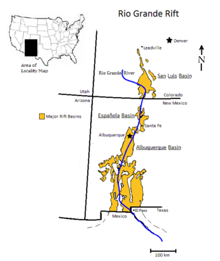
The Rio Grande rift is a north-trending continental rift zone. It separates the Colorado Plateau in the west from the interior of the North American craton on the east. The rift extends from central Colorado in the north to the state of Chihuahua, Mexico, in the south. The rift zone consists of four basins that have an average width of 50 kilometres (31 mi). The rift can be observed on location at Rio Grande National Forest, White Sands National Park, Santa Fe National Forest, and Cibola National Forest, among other locations.

The Basin and Range Province is a vast physiographic region covering much of the inland Western United States and northwestern Mexico. It is defined by unique basin and range topography, characterized by abrupt changes in elevation, alternating between narrow faulted mountain chains and flat arid valleys or basins. The physiography of the province is the result of tectonic extension that began around 17 million years ago in the early Miocene epoch.

The North American Plate is a tectonic plate containing most of North America, Cuba, the Bahamas, extreme northeastern Asia, and parts of Iceland and the Azores. With an area of 76 million km2 (29 million sq mi), it is the Earth's second largest tectonic plate, behind the Pacific Plate.

In geology, a graben is a depressed block of the crust of a planet or moon, bordered by parallel normal faults.

In geology, a rift is a linear zone where the lithosphere is being pulled apart and is an example of extensional tectonics. Typical rift features are a central linear downfaulted depression, called a graben, or more commonly a half-graben with normal faulting and rift-flank uplifts mainly on one side. Where rifts remain above sea level they form a rift valley, which may be filled by water forming a rift lake. The axis of the rift area may contain volcanic rocks, and active volcanism is a part of many, but not all, active rift systems.
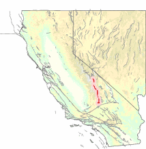
The Sierra Nevada Fault is an active seismic fault along the eastern edge of the Sierra Nevada mountain block in California. It forms the eastern escarpment of the Sierra Nevada, extending roughly 600 km (370 mi) from just north of the Garlock Fault to the Cascade Range.
This is a list of articles related to plate tectonics and tectonic plates.
Wagner Basin is a submarine depression in the far northern part of the Gulf of California. The basin is currently tectonically active. It is the northernmost underwater depression associated with the East Pacific Rise and is located near the southern end of the Cerro Prieto fault. The depression is a result of subsidence caused by the extensional forces imparted by a spreading center. The Wagner Basin is bounded on its eastern side by the Wagner Fault, a primarily normal fault which dips approximately 60 degrees to the northwest. The western side of the basin is bounded by another normal fault, the Consag Fault which dips in a direction opposite the Wagner Fault. The seabed between these faults is sinking. The basin is linked to the dextral Cerro Prieto Fault at its north end.
The Delfin Basin is a pair of interconnected submarine depressions located on the seabed of the northern Gulf of California. The northernmost of these is called the Upper Delfin Basin while the southernmost is called the Lower Delfin Basin. Both of these features are areas of subsidence caused by extensional forces imparted by a spreading center associated with the East Pacific Rise. The two basins are linked by a short transform fault which was the apparent source of an earthquake of magnitude 5.5 on November 26, 1997.
The Guaymas Fault, named for the city of Guaymas, Sonora, Mexico, is a major right lateral-moving transform fault which runs along the seabed of the Gulf of California. It is an integral part of the Gulf of California Rift Zone, the northern extremity of the East Pacific Rise. The Guaymas Fault runs from the San Pedro Martir Basin located at the southern end of the San Lorenzo Fault, and extends southward to the Guaymas Basin, a heavily sedimented rift which includes both continental and oceanic crust and contains numerous hydrothermal vents.
The Gulf of California Rift Zone (GCRZ) is the northernmost extension of the East Pacific Rise which extends some 1,300 km (800 mi) from the mouth of the Gulf of California to the southern terminus of the San Andreas Fault at the Salton Sink.
The Tamayo Fault is a major right lateral-moving transform fault located on the seabed at the mouth of the Gulf of California. The fault is the southernmost transform in the Gulf of California Rift Zone. The fault links the Rivera Ridge segment of the East Pacific Rise in the south with the Alarcon Basin in the north.
The Alarcon Basin is a submarine depression located on the seabed at the southern end of the Gulf of California. The basin results from the activity of the southernmost spreading center in the Gulf. This spreading center has also produced the southernmost oceanic rift in the Gulf of California Rift Zone, the Alarcon Rise. The basin and rise are linked to the Tamayo Fault to the south, and the Pescadero Fault in the north.
The Carmen Fault is a right lateral-moving transform fault located on the seafloor of the southern Gulf of California. It links the Guaymas Basin to the north with the Carmen Basin to the south. All these features are part of the Gulf of California Rift Zone, the northern extension of the East Pacific Rise.
The Pescadero Fault is a right lateral-moving transform fault located on the seafloor of the southern Gulf of California. It links the Pescadero Basin to the north with the Alarcon Basin to the south. All these features are part of the Gulf of California Rift Zone, the northern extension of the East Pacific Rise.
The Atl Fault is a right lateral-moving transform fault located on the seafloor of the southern Gulf of California. It links the Farallon Basin to the north with the Pescadero Basin to the south. All these features are part of the Gulf of California Rift Zone, the northern extension of the East Pacific Rise.
The Farallon Basin is a submarine depression located on the seabed at the southern end of the Gulf of California. The basin results from the activity of one of the several spreading centers in the Gulf. The basin is linked to the Atl Fault to the south, and the Farallon Fault in the north.
The Carmen Basin is a submarine depression located on the seabed at the southern end of the Gulf of California. The basin results from the activity of one of the several spreading centers in the Gulf. The basin is linked to the Farallon Fault to the south, and the Carmen Fault in the north.

The geology of North America is a subject of regional geology and covers the North American continent, the third-largest in the world. Geologic units and processes are investigated on a large scale to reach a synthesized picture of the geological development of the continent.
A transfer zone in geology is an area where deformational strain is transferred from one structural element to another typically from fault to fault in rift systems. Therefore, listric faults and monoclinal folds in the hanging wall are typical structures linked by transfer zones; however, complexities do exist. The terms interbasin and intrabasin transfer zones have been proposed to delineate the magnitude of the transfer zone. Transfer zones can be described according to the fault dip directions; synthetic or conjugate and according to their deformation style; convergent or divergent. Transfer zones can be farther identified by its maturity or ; whether the major fault relationship is approaching, overlapping, collateral or collinear. Since transfer zones are normally found in extensional settings many studies have been done within the East African rift system and the Gulf of Suez rift system. Transfer zones have also played a role in hydrocarbon exploration and extraction within the Albertine graben.