Related Research Articles

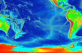
Seafloor spreading is a process that occurs at mid-ocean ridges, where new oceanic crust is formed through volcanic activity and then gradually moves away from the ridge.

The North American Plate is a tectonic plate covering most of North America, Greenland, Cuba, the Bahamas, extreme northeastern Asia, and parts of Iceland and the Azores. It extends eastward to the Mid-Atlantic Ridge and westward to the Chersky Range in eastern Siberia. The plate includes both continental and oceanic crust. The interior of the main continental landmass includes an extensive granitic core called a craton. Along most of the edges of this craton are fragments of crustal material called terranes, accreted to the craton by tectonic actions over a long span of time. It is thought that much of North America west of the Rocky Mountains is composed of such terranes.

In geology, a rift is a linear zone where the lithosphere is being pulled apart and is an example of extensional tectonics.
The East Pacific Rise is a mid-oceanic ridge, a divergent tectonic plate boundary located along the floor of the Pacific Ocean. It separates the Pacific Plate to the west from the North American Plate, the Rivera Plate, the Cocos Plate, the Nazca Plate, and the Antarctic Plate. It runs south from the Gulf of California in the Salton Sea basin in southern California to a point near 55° S, 130° W where it joins the Pacific-Antarctic Ridge trending west-southwest towards Antarctica near New Zealand. Much of the rise lies about 3200 km (2000 mi) off the South American coast and rises about 1,800–2,700 m (6,000–9,000 ft) above the surrounding seafloor.

The Red Sea Rift is a spreading center between two tectonic plates, the African Plate and the Arabian Plate. It extends from the Dead Sea Transform fault system, and ends at an intersection with the Aden Ridge and the East African Rift, forming the Afar Triple Junction in the Afar Depression of the Horn of Africa.
This is a list of articles related to plate tectonics and tectonic plates.
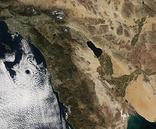
The Brawley Seismic Zone (BSZ), also known as the Brawley fault zone, is a predominantly extensional tectonic zone that connects the southern terminus of the San Andreas Fault with the Imperial Fault in Southern California. The BSZ is named for the nearby town of Brawley in Imperial County, California, and the seismicity there is characterized by earthquake swarms.
The Cerro Prieto Fault is a transform fault located in far northern Baja California. It runs between the Cerro Prieto spreading center located southwest of Mexicali, and the Wagner Basin, another spreading center which lies under the Gulf of California. These spreading centers are part of the East Pacific Rise, the northern leg of which has formed the Gulf of California by steadily rifting the Baja California Peninsula away from the mainland of Mexico.
Wagner Basin is a submarine depression in the far northern part of the Gulf of California. The basin is currently tectonically active. It is the northernmost underwater depression associated with the East Pacific Rise and is located near the southern end of the Cerro Prieto fault. The depression is a result of subsidence caused by the extensional forces imparted by a spreading center. The Wagner Basin is bounded on its eastern side by the Wagner Fault, a primarily normal fault which dips approximately 60 degrees to the northwest. The western side of the basin is bounded by another normal fault, the Consag Fault which dips in a direction opposite the Wagner Fault. The seabed between these faults is sinking. The basin is linked to the dextral Cerro Prieto Fault at its north end.
The Delfin Basin is a pair of interconnected submarine depressions located on the seabed of the northern Gulf of California. The northernmost of these is called the Upper Delfin Basin while the southernmost is called the Lower Delfin Basin. Both of these features are areas of subsidence caused by extensional forces imparted by a spreading center associated with the East Pacific Rise. The two basins are linked by a short transform fault which was the apparent source of an earthquake of magnitude 5.5 on November 26, 1997.
The Guaymas Fault, named for the city of Guaymas, Sonora, Mexico, is a major right lateral-moving transform fault which runs along the seabed of the Gulf of California. It is an integral part of the Gulf of California Rift Zone, the northern extremity of the East Pacific Rise. The Guaymas Fault runs from the San Pedro Martir Basin located at the southern end of the San Lorenzo Fault, and extends southward to the Guaymas Basin, a heavily sedimented rift which includes both continental and oceanic crust and contains numerous hydrothermal vents.
The Carmen Fault is a right lateral-moving transform fault located on the seafloor of the southern Gulf of California. It links the Guaymas Basin to the north with the Carmen Basin to the south. All these features are part of the Gulf of California Rift Zone, the northern extension of the East Pacific Rise.
The Farallon Fault is a right lateral-moving transform fault located on the seafloor of the southern Gulf of California. It links the Carmen Basin to the north with the Farallon Basin to the south. All these features are part of the Gulf of California Rift Zone, the northern extension of the East Pacific Rise.
The Pescadero Basin is a submarine depression located on the seabed at the southern end of the Gulf of California. The basin results from the activity of one of the several spreading centers in the Gulf. The basin is linked to the Pescadero Fault to the south, and the Atl Fault in the north.
The Atl Fault is a right lateral-moving transform fault located on the seafloor of the southern Gulf of California. It links the Farallon Basin to the north with the Pescadero Basin to the south. All these features are part of the Gulf of California Rift Zone, the northern extension of the East Pacific Rise.
The Farallon Basin is a submarine depression located on the seabed at the southern end of the Gulf of California. The basin results from the activity of one of the several spreading centers in the Gulf. The basin is linked to the Atl Fault to the south, and the Farallon Fault in the north.
The Carmen Basin is a submarine depression located on the seabed at the southern end of the Gulf of California. The basin results from the activity of one of the several spreading centers in the Gulf. The basin is linked to the Farallon Fault to the south, and the Carmen Fault in the north.