The North American Plate is a tectonic plate containing most of North America, Cuba, the Bahamas, extreme northeastern Asia, and parts of Iceland and the Azores. With an area of 76 million km2 (29 million sq mi), it is the Earth's second largest tectonic plate, behind the Pacific Plate.

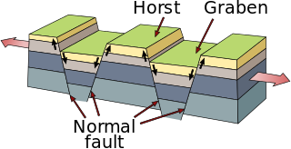
In geology, a graben is a depressed block of the crust of a planet or moon, bordered by parallel normal faults.

The Gran Desierto de Altar is one of the major sub-ecoregions of the Sonoran Desert, located in the State of Sonora, in northwest Mexico. It includes the only active erg dune region in North America. The desert extends across much of the northern border of the Gulf of California, spanning more than 100 kilometres (62 mi) east to west and over 50 kilometres (31 mi) north to south. It constitutes the largest continuous wilderness area within the Sonoran Desert.

The Coyote Mountains are a small mountain range in San Diego and Imperial Counties in southern California. The Coyotes form a narrow ESE trending 2 mi (3.2 km) wide range with a length of about 12 mi (19 km). The southeast end turns and forms a 2 mi (3.2 km) north trending "hook". The highest point is Carrizo Mountain on the northeast end with an elevation of 2,408 feet (734 m). Mine Peak at the northwest end of the range has an elevation of 1,850 ft (560 m). Coyote Wash along I-8 along the southeast margin of the range is 100 to 300 feet in elevation. Plaster City lies in the Yuha Desert about 5.5 mi (8.9 km) east of the east end of the range.
The Brawley Seismic Zone (BSZ), also known as the Brawley fault zone, is a predominantly extensional tectonic zone that connects the southern terminus of the San Andreas Fault with the Imperial Fault in Southern California. The BSZ is named for the nearby town of Brawley in Imperial County, California, and the seismicity there is characterized by earthquake swarms.
The Cerro Prieto Fault is a transform fault located in far northern Baja California. It runs between the Cerro Prieto spreading center located southwest of Mexicali, and the Wagner Basin, another spreading center which lies under the Gulf of California. These spreading centers are part of the East Pacific Rise, the northern leg of which has formed the Gulf of California by steadily rifting the Baja California Peninsula away from the mainland of Mexico.
Wagner Basin is a submarine depression in the far northern part of the Gulf of California. The basin is currently tectonically active. It is the northernmost underwater depression associated with the East Pacific Rise and is located near the southern end of the Cerro Prieto fault. The depression is a result of subsidence caused by the extensional forces imparted by a spreading center. The Wagner Basin is bounded on its eastern side by the Wagner Fault, a primarily normal fault which dips approximately 60 degrees to the northwest. The western side of the basin is bounded by another normal fault, the Consag Fault which dips in a direction opposite the Wagner Fault. The seabed between these faults is sinking. The basin is linked to the dextral Cerro Prieto Fault at its north end.
The Delfin Basin is a pair of interconnected submarine depressions located on the seabed of the northern Gulf of California. The northernmost of these is called the Upper Delfin Basin while the southernmost is called the Lower Delfin Basin. Both of these features are areas of subsidence caused by extensional forces imparted by a spreading center associated with the East Pacific Rise. The two basins are linked by a short transform fault which was the apparent source of an earthquake of magnitude 5.5 on November 26, 1997.
The Consag Basin is a submarine depression in the far northern part of the Gulf of California associated with the East Pacific Rise. It lies south of the Wagner Basin with which it is closely linked. The depression is a result of subsidence caused by the extensional forces probably imparted by the same spreading center which has produced the Wagner Basin. Both basins are bounded on their eastern side by the Wagner Fault, a primarily normal fault which dips approximately 60 degrees to the northwest. The western side of the basin is bounded by another normal fault, the Consag Fault which dips in a direction opposite the Wagner Fault. The seabed between these faults is sinking.
The Ballenas Fault is a transform fault located on the seabed of the Gulf of California, extending through the Canal de Ballenas which separates the Isla Ángel de la Guarda from the Baja California Peninsula. The fault is an integral part of the East Pacific Rise, linking the Delfin Basin in the north with a smaller spreading center to the south. The fault is considered the northernmost member of a grouping of four transform faults called the Guaymas Transform Fault System.
The Guaymas Fault, named for the city of Guaymas, Sonora, Mexico, is a major right lateral-moving transform fault which runs along the seabed of the Gulf of California. It is an integral part of the Gulf of California Rift Zone, the northern extremity of the East Pacific Rise. The Guaymas Fault runs from the San Pedro Martir Basin located at the southern end of the San Lorenzo Fault, and extends southward to the Guaymas Basin, a heavily sedimented rift which includes both continental and oceanic crust and contains numerous hydrothermal vents.
The Gulf of California Rift Zone (GCRZ) is the northernmost extension of the East Pacific Rise which extends some 1,300 km (800 mi) from the mouth of the Gulf of California to the southern terminus of the San Andreas Fault at the Salton Sink.
The Tamayo Fault is a major right lateral-moving transform fault located on the seabed at the mouth of the Gulf of California. The fault is the southernmost transform in the Gulf of California Rift Zone. The fault links the Rivera Ridge segment of the East Pacific Rise in the south with the Alarcon Basin in the north.
The Alarcon Basin is a submarine depression located on the seabed at the southern end of the Gulf of California. The basin results from the activity of the southernmost spreading center in the Gulf. This spreading center has also produced the southernmost oceanic rift in the Gulf of California Rift Zone, the Alarcon Rise. The basin and rise are linked to the Tamayo Fault to the south, and the Pescadero Fault in the north.
The Carmen Fault is a right lateral-moving transform fault located on the seafloor of the southern Gulf of California. It links the Guaymas Basin to the north with the Carmen Basin to the south. All these features are part of the Gulf of California Rift Zone, the northern extension of the East Pacific Rise.
The Farallon Fault is a right lateral-moving transform fault located on the seafloor of the southern Gulf of California. It links the Carmen Basin to the north with the Farallon Basin to the south. All these features are part of the Gulf of California Rift Zone, the northern extension of the East Pacific Rise.
The Pescadero Basin is a submarine depression located on the seabed at the southern end of the Gulf of California off the coast of the Mexican state of Sinaloa. The basin results from the activity of one of the several spreading centers in the Gulf. The basin is linked to the Pescadero Fault to the south, and the Atl Fault in the north, two of the transform faults of the Gulf of California Rift Zone, i. e. the northern extension of the eastern Pacific Ridge.
The Atl Fault is a right lateral-moving transform fault located on the seafloor of the southern Gulf of California. It links the Farallon Basin to the north with the Pescadero Basin to the south. All these features are part of the Gulf of California Rift Zone, the northern extension of the East Pacific Rise.
The Guaymas Basin is the largest marginal rift basin located in the Gulf of California. It made up of the northern and southern trough and is linked to the Guaymas Fault to the north and the Carmen Fault to the south. The mid-ocean ridge system is responsible for the creation of the Guaymas Basin and giving it many features such as hydrothermal circulation and hydrocarbon seeps. Hydrothermal circulation is a significant process in the Guaymas Basin because it recycles energy and nutrients which are instrumental in sustaining the basin's rich ecosystem. Additionally, hydrocarbons and other organic matter are needed to feed a variety of organisms, many of which have adapted to tolerate the basin's high temperatures.

The Salton Trough is an active tectonic pull-apart basin, or graben. It lies within the Imperial, Riverside, and San Diego counties of southeastern California and extends south of the Mexico–United States border into the state of Baja California.


