Related Research Articles
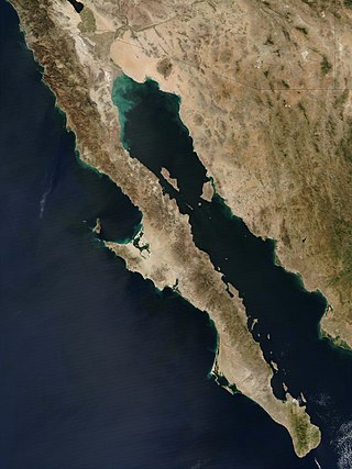
The Baja California peninsula is a peninsula in northwestern Mexico. It separates the Gulf of California from the Pacific Ocean. The peninsula extends from Mexicali, Baja California, in the north to Cabo San Lucas, Baja California Sur, in the south.

The Gulf of California, also known as the Sea of Cortés or Sea of Cortez, or less commonly as the Vermilion Sea, is a marginal sea of the Pacific Ocean that separates the Baja California peninsula from the Mexican mainland. It is bordered by the states of Baja California, Baja California Sur, Sonora, and Sinaloa with a coastline of approximately 4,000 km (2,500 mi). Rivers that flow into the Gulf of California include the Colorado, Fuerte, Mayo, Sinaloa, Sonora, and the Yaqui. The surface of the gulf is about 160,000 km2 (62,000 sq mi). Maximum depths exceed 3,000 meters (9,800 ft) because of the complex geology, linked to plate tectonics.

The North American plate is a tectonic plate containing most of North America, Cuba, the Bahamas, extreme northeastern Asia, and parts of Iceland and the Azores. With an area of 76 million km2 (29 million sq mi), it is the Earth's second largest tectonic plate, behind the Pacific plate.
The East Pacific Rise (EPR) is a mid-ocean rise, at a divergent tectonic plate boundary, located along the floor of the Pacific Ocean. It separates the Pacific plate to the west from the North American plate, the Rivera plate, the Cocos plate, the Nazca plate, and the Antarctic plate. It runs south from the Gulf of California in the Salton Sea basin in Southern California to a point near 55°S130°W, where it joins the Pacific-Antarctic Ridge (PAR) trending west-south-west towards Antarctica, near New Zealand. Much of the rise lies about 3,200 km (2,000 mi) off the South American coast and reaches a height about 1,800–2,700 m (5,900–8,900 ft) above the surrounding seafloor.

The Explorer Ridge is a mid-ocean ridge, a divergent tectonic plate boundary located about 241 km (150 mi) west of Vancouver Island, British Columbia, Canada. It lies at the northern extremity of the Pacific spreading axis. To its east is the Explorer plate, which together with the Juan de Fuca plate and the Gorda plate to its south, is what remains of the once-vast Farallon plate which has been largely subducted under the North American plate. The Explorer Ridge consists of one major segment, the Southern Explorer Ridge, and several smaller segments. It runs northward from the Sovanco Fracture Zone to the Queen Charlotte triple junction, a point where it meets the Queen Charlotte Fault and the northern Cascadia subduction zone.
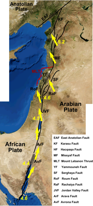
The Dead Sea Transform (DST) fault system, also sometimes referred to as the Dead Sea Rift, is a series of faults that run for about 1,000 km from the Maras Triple Junction to the northern end of the Red Sea Rift. The fault system forms the transform boundary between the African plate to the west and the Arabian plate to the east. It is a zone of left lateral (sinistral) displacement, signifying the relative motions of the two plates. Both plates are moving in a general north-northeast direction, but the Arabian plate is moving faster, resulting in the observed left lateral motions along the fault of approximately 107 km at its southern end. A component of extension is also present in the southern part of the transform, which has contributed to a series of depressions, or pull-apart basins, forming the Gulf of Aqaba, Dead Sea, Sea of Galilee, and Hula basins. A component of shortening affects the Lebanon restraining bend, leading to uplift on both sides of the Beqaa valley. There is local transtension in the northernmost part of the fault system, forming the Ghab pull-apart basin. The southern part of the fault system runs roughly along the political border of Lebanon and Israel on its western side, and southern Syria and Jordan on the eastern side.

West Mata is an active submarine volcano located in the northeastern Lau Basin, roughly 200 km (124 mi) southwest of the Samoan Islands. It is part of the Tonga-Kermadec volcanic arc, which stretches from the North Island of New Zealand to Samoa. The volcano was first discovered in 2008 by scientists aboard the R/V Thompson research vessel, using sonar mapping and a remotely operated vehicle (ROV) to explore the seafloor. At the same time West Mata was discovered, multiple neighboring volcanoes—most of them hydrothermally active—were discovered as well, including Volcano O, Tafu-Maka, Northern Matas and East Mata.
The Brawley Seismic Zone (BSZ), also known as the Brawley fault zone, is a predominantly extensional tectonic zone that connects the southern terminus of the San Andreas Fault with the Imperial Fault in Southern California. The BSZ is named for the nearby town of Brawley in Imperial County, California, and the seismicity there is characterized by earthquake swarms.
The Cerro Prieto Fault is a transform fault located in far northern Baja California. It runs between the Cerro Prieto spreading center located southwest of Mexicali, and the Wagner Basin, another spreading center which lies under the Gulf of California. These spreading centers are part of the East Pacific Rise, the northern leg of which has formed the Gulf of California by steadily rifting the Baja California Peninsula away from the mainland of Mexico.
The Delfin Basin is a pair of interconnected submarine depressions located on the seabed of the northern Gulf of California. The northernmost of these is called the Upper Delfin Basin while the southernmost is called the Lower Delfin Basin. Both of these features are areas of subsidence caused by extensional forces imparted by a spreading center associated with the East Pacific Rise. The two basins are linked by a short transform fault which was the apparent source of an earthquake of magnitude 5.5 on November 26, 1997.
The Ballenas Fault is a transform fault located on the seabed of the Gulf of California, extending through the Canal de Ballenas which separates the Isla Ángel de la Guarda from the Baja California Peninsula. The fault is an integral part of the East Pacific Rise, linking the Delfin Basin in the north with a smaller spreading center to the south. The fault is considered the northernmost member of a grouping of four transform faults called the Guaymas Transform Fault System.
The Gulf of California Rift Zone (GCRZ) is the northernmost extension of the East Pacific Rise which extends some 1,300 km (800 mi) from the mouth of the Gulf of California to the southern terminus of the San Andreas Fault at the Salton Sink.
The Carmen Fault is a right lateral-moving transform fault located on the seafloor of the southern Gulf of California. It links the Guaymas Basin to the north with the Carmen Basin to the south. All these features are part of the Gulf of California Rift Zone, the northern extension of the East Pacific Rise.
The Pescadero Basin is a submarine depression located on the seabed at the southern end of the Gulf of California off the coast of the Mexican state of Sinaloa. The basin results from the activity of one of the several spreading centers in the Gulf. The basin is linked to the Pescadero Fault to the south, and the Atl Fault in the north, two of the transform faults of the Gulf of California Rift Zone, i. e. the northern extension of the eastern Pacific Ridge.
The Guaymas Basin is the largest marginal rift basin located in the Gulf of California. It made up of the northern and southern trough and is linked to the Guaymas Fault to the north and the Carmen Fault to the south. The mid-ocean ridge system is responsible for the creation of the Guaymas Basin and giving it many features such as hydrothermal circulation and hydrocarbon seeps. Hydrothermal circulation is a significant process in the Guaymas Basin because it recycles energy and nutrients which are instrumental in sustaining the basin's rich ecosystem. Additionally, hydrocarbons and other organic matter are needed to feed a variety of organisms, many of which have adapted to tolerate the basin's high temperatures.

The Salton Trough is an active tectonic pull-apart basin, or graben. It lies within the Imperial, Riverside, and San Diego counties of southeastern California and extends south of the Mexico–United States border into the state of Baja California.

The San Quintín Volcanic Field is a collection of ten or eleven volcanic cinder cones situated along the Pacific coast of the Baja California peninsula in Mexico. The field formed by repeated eruptions beginning in the Pleistocene and ending about 3000 years ago. It is one of several known Quaternary period volcanic fields in Baja. The lava shields appear to have first grown as subaqueous volcanoes that emerged as islands.

The Woodlark Basin is a young geologic structural basin located in the southwestern Pacific Ocean, found to the southeast of the island country of Papua New Guinea. The basin is an extensional basin that is actively spreading and has a seafloor spreading center. The basin formed between the then Indo-Australian Plate and the Solomon microplate creating the presently independent Woodlark Plate. The Woodlark Basin has a complex geologic history dating back twenty million years to the initial opening of the basin but most of the spreading has happened in the last 3.6 million years.

La Reforma is a Plio-Pleistocene caldera on the Baja California Peninsula in Mexico. It is part of eleven volcanoes in Baja California, which formed with the Gulf of California during the Miocene, about ten million years ago. Previously, a volcanic arc had existed on the peninsula. The caldera's basement consists of granites and monzonites, formed between the Cretaceous and the Middle Miocene.
The 1981 Westmorland earthquake occurred at 05:09 Pacific Daylight Time on April 26. The moderate strike-slip shock took place in the Imperial Valley of Southern California, just north of the Mexico–United States border. No injuries or deaths occurred, but damage was estimated at $1–3 million. With a Mercalli intensity of VII, this was one of fifteen intensity VII or greater shocks in the Imperial Valley that were observed in the 20th century up until April 1981. The region experiences large stand-alone events and earthquake swarms due to its position in an area of complex conditions where faulting transitions from strike-slip movement to the north and divergence to the south.
References
- The NARS-Baja Seismic Array in the Gulf of California Rift Zone, Clayton, R. W., et al. (2004), Margins Newsletter
- A Brief Review of Heat-Flow Studies in the Guaymas Basin, Gulf of California, Chapter 33, Part VI, Hydrothermal Processes, K. Becker, A. T. Fisher, AAPG Special Volumes, Volume M 47: The Gulf and Peninsular Province of the Californias, Pages 709–720 (1991)
- Microbial Utilization of Naturally Occurring Hydrocarbons at the Guaymas Basin Hydrothermal Vent Site, Bazylinski et al (1989)
- Relationship of the Puertecitos Volcanic Province Baja California Mexico to the Development of the Plate Boundary in the Gulf of California, Joann M. Stock (2000), in SPE, Geological Society of America, p.143
- Late Miocene volcanism and marine incursions in the San Lorenzo Archipelago, Gulf of California, Mexico, Escalona-Alcázar et al (2001), map p.113 Archived 2017-08-10 at the Wayback Machine
| | This Mexico location article is a stub. You can help Wikipedia by expanding it. |
| | This tectonics article is a stub. You can help Wikipedia by expanding it. |