Related Research Articles

The San Andreas Fault is a continental right-lateral strike-slip transform fault that extends roughly 1,200 kilometers (750 mi) through the U.S. state of California. It forms part of the tectonic boundary between the Pacific plate and the North American plate. Traditionally, for scientific purposes, the fault has been classified into three main segments, each with different characteristics and a different degree of earthquake risk. The average slip rate along the entire fault ranges from 20 to 35 mm per year.
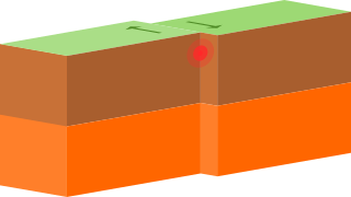
A transform fault or transform boundary, is a fault along a plate boundary where the motion is predominantly horizontal. It ends abruptly where it connects to another plate boundary, either another transform, a spreading ridge, or a subduction zone. A transform fault is a special case of a strike-slip fault that also forms a plate boundary.

The North American plate is a tectonic plate containing most of North America, Cuba, the Bahamas, extreme northeastern Asia, and parts of Iceland and the Azores. With an area of 76 million km2 (29 million sq mi), it is the Earth's second largest tectonic plate, behind the Pacific plate.

The Cocos plate is a young oceanic tectonic plate beneath the Pacific Ocean off the west coast of Central America, named for Cocos Island, which rides upon it. The Cocos plate was created approximately 23 million years ago when the Farallon plate broke into two pieces, which also created the Nazca plate. The Cocos plate also broke into two pieces, creating the small Rivera plate. The Cocos plate is bounded to the northeast by the North American plate and the Caribbean plate. To the west it is bounded by the Pacific plate and to the south by the Nazca plate.
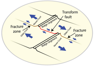
A fracture zone is a linear feature on the ocean floor—often hundreds, even thousands of kilometers long—resulting from the action of offset mid-ocean ridge axis segments. They are a consequence of plate tectonics. Lithospheric plates on either side of an active transform fault move in opposite directions; here, strike-slip activity occurs. Fracture zones extend past the transform faults, away from the ridge axis; are usually seismically inactive, although they can display evidence of transform fault activity, primarily in the different ages of the crust on opposite sides of the zone.
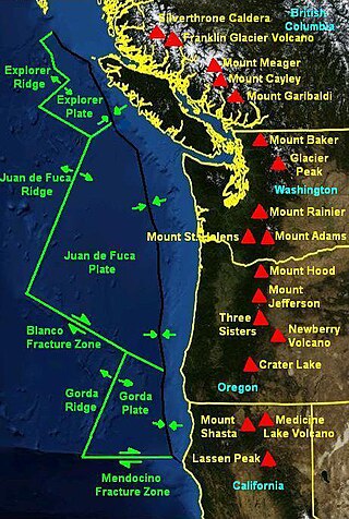
The Mendocino Fracture Zone is a fracture zone and transform boundary over 4000 km long, starting off the coast of Cape Mendocino in far northern California. It runs westward from a triple junction with the San Andreas Fault and the Cascadia subduction zone to the southern end of the Gorda Ridge. It continues on west of its junction with the Gorda Ridge, as an inactive remnant section which extends for several hundred miles.
Strike-slip tectonics or wrench tectonics is a type of tectonics that is dominated by lateral (horizontal) movements within the Earth's crust. Where a zone of strike-slip tectonics forms the boundary between two tectonic plates, this is known as a transform or conservative plate boundary. Areas of strike-slip tectonics are characterised by particular deformation styles including: stepovers, Riedel shears, flower structures and strike-slip duplexes. Where the displacement along a zone of strike-slip deviates from parallelism with the zone itself, the style becomes either transpressional or transtensional depending on the sense of deviation. Strike-slip tectonics is characteristic of several geological environments, including oceanic and continental transform faults, zones of oblique collision and the deforming foreland of zones of continental collision.
The Queen Charlotte Fault is an active transform fault that marks the boundary of the North American plate and the Pacific plate. It is Canada's right-lateral strike-slip equivalent to the San Andreas Fault to the south in California. The Queen Charlotte Fault forms a triple junction south with the Cascadia subduction zone and the Explorer Ridge. The Queen Charlotte Fault (QCF) forms a transpressional plate boundary, and is as active as other major transform fault systems in terms of slip rates and seismogenic potential. It sustains the highest known deformation rates among continental or continent-ocean transform systems globally, accommodating greater than 50mm/yr dextral offset. The entire approximately 900 km offshore length has ruptured in seven greater than magnitude 7 events during the last century, making the cumulative historical seismic moment release higher than any other modern transform plate boundary system.

The Rivera plate is a small tectonic plate located off the west coast of Mexico, just south of the Baja California peninsula. It is bounded on the northwest by the East Pacific Rise, on the southwest by the Rivera Transform Fault, on the southeast by a deformation zone, and on the northeast by the Middle America Trench and another deformation zone.

The Explorer Ridge is a mid-ocean ridge, a divergent tectonic plate boundary located about 241 km (150 mi) west of Vancouver Island, British Columbia, Canada. It lies at the northern extremity of the Pacific spreading axis. To its east is the Explorer plate, which together with the Juan de Fuca plate and the Gorda plate to its south, is what remains of the once-vast Farallon plate which has been largely subducted under the North American plate. The Explorer Ridge consists of one major segment, the Southern Explorer Ridge, and several smaller segments. It runs northward from the Sovanco Fracture Zone to the Queen Charlotte triple junction, a point where it meets the Queen Charlotte Fault and the northern Cascadia subduction zone.
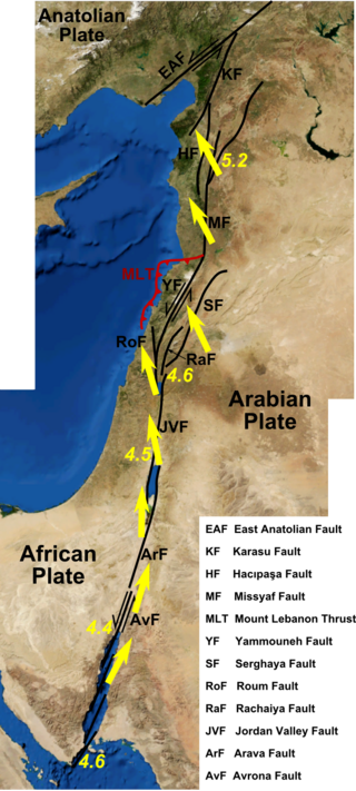
The Dead Sea Transform (DST) fault system, also sometimes referred to as the Dead Sea Rift, is a series of faults that run for about 1,000 km from the Maras Triple Junction to the northern end of the Red Sea Rift. The fault system forms the transform boundary between the African plate to the west and the Arabian plate to the east. It is a zone of left lateral (sinistral) displacement, signifying the relative motions of the two plates. Both plates are moving in a general north-northeast direction, but the Arabian plate is moving faster, resulting in the observed left lateral motions along the fault of approximately 107 km at its southern end. A component of extension is also present in the southern part of the transform, which has contributed to a series of depressions, or pull-apart basins, forming the Gulf of Aqaba, Dead Sea, Sea of Galilee, and Hula basins. A component of shortening affects the Lebanon restraining bend, leading to uplift on both sides of the Beqaa valley. There is local transtension in the northernmost part of the fault system, forming the Ghab pull-apart basin. The southern part of the fault system runs roughly along the political border of Lebanon and Israel on its western side, and southern Syria and Jordan on the eastern side.

The Macquarie triple junction is a geologically active tectonic boundary located at 61°30′S161°0′E at which the historic Indo-Australian Plate, Pacific Plate, and Antarctic Plate collide and interact. The term triple junction is given to particular tectonic boundaries at which three separate tectonic plates meet at a specific, singular location. The Macquarie triple junction is located on the seafloor of the southern region of the Pacific Ocean, just south of New Zealand. This tectonic boundary was named in respect to the nearby Macquarie Island, which is located southeast of New Zealand.

The 1,600 kilometres (990 mi) long Macquarie Fault Zone is a major right lateral-moving transform fault along the seafloor of the south Pacific Ocean which runs from New Zealand southwestward towards the Macquarie Triple Junction. It is also the tectonic plate boundary between the Australian plate to the northwest and the Pacific plate to the southeast. As such it is a region of high seismic activity and recorded the largest strike-slip event on record up to 23 May 1989, of at least Mw8.0
The Rivera triple junction (RTJ) is a geologic triple junction located on the seafloor of the Pacific Ocean southeast of the southern tip of the Baja California peninsula. At the RTJ, three tectonic plates intersect: the North American plate, the Rivera plate, and the Pacific plate. The triple junction is often referenced as the southern counterpart of the Mendocino triple junction, but it is not as well understood. One research effort describes it as an R-R-R (ridge-ridge-ridge) type junction which lies along the segment of the East Pacific Rise which runs between the Rivera Transform Fault and the Tamayo Fault, although the third axis of the junction is not clearly defined. Part of the problem in describing the Rivera triple junction is that if it were truly analogous to the Mendocino triple junction, then it would exist at the junction of the East Pacific Rise, the Tamayo Fault, and the Middle America Trench. But thus far, there does not appear to be any evidence that the Tamayo Fault or the East Pacific Rise intersect the Middle America Trench at all, thus presenting a possible example of a diffuse triple junction.
The Queen Charlotte triple junction is a geologic triple junction where three tectonic plates meet: the Pacific plate, the North American plate, and the Explorer plate. The three plate boundaries which intersect here are the Queen Charlotte Fault, the northern Cascadia subduction zone, and the Explorer Ridge. The Queen Charlotte triple junction is currently positioned adjacent to the Queen Charlotte Sound near the Dellwood Knolls off the coast of Vancouver Island. 10 Ma to 1.5 Ma prior to the triple junction's current location, it was located southwest of Vancouver Island The movements of the triple junction have been characterized by two major shifts in the Pacific-North American Tertiary plate tectonic record. First, at approximately 40 Ma the relative plate motions switched from orthogonal convergence to right-lateral strike slip. The variance in location of the triple junction may have also been related to the formation of an independent basin block. This formation could have been produced by fore-arc bending of the Pacific plate, due to oblique underthrusting prior to 1 Ma which produced stresses sufficient to break the Pacific plate and isolate the block. Transpression of 15–30 mm/yr since 5 Ma has been taking place, as well as varying amounts of both transpression and transtension occurring before then. To the northwest of the triple junction the Pacific plate currently has 15 degrees of oblique convergence, passing under the North American plate along the Queen Charlotte transform fault zone. The Explorer plate is a small chunk of the Juan de Fuca plate that broke away from the Juan de Fuca plate about 3.5 Ma and has moved much slower with respect to North America.
The 2009 Swan Islands earthquake occurred on May 28 at 02:24:45 AM local time with a moment magnitude of 7.3 and a maximum Mercalli intensity of VII. The epicenter was located in the Caribbean Sea, 64 kilometres (40 mi) northeast of the island of Roatán, 19 miles northeast of Port Royal, Isla de Bahias, 15 miles northwest of Isla Barbaretta, and 130 kilometres (81 mi) north-northeast of La Ceiba. Three aftershocks followed the earthquake within magnitude 4 range.
The Tamayo Fault is a major right lateral-moving transform fault located on the seabed at the mouth of the Gulf of California. The fault is the southernmost transform in the Gulf of California Rift Zone. The fault links the Rivera Ridge segment of the East Pacific Rise in the south with the Alarcon Basin in the north.
The Emerald Fracture Zone is an undersea fracture zone running the distance from the southwest corner of the Campbell Plateau to the northern tip of Iselin Bank. The name was proposed by Dr. Steven C. Cande of the Scripps Institution of Oceanography for the vessel Emerald, which traversed this region in 1821, and was approved by the Advisory Committee for Undersea Features in June 1997. The Emerald Basin to its north west was named from the same source. Some have restricted the name to the southern east west orientated transform fault zone but the north south orientated faults that define the eastern boundary of the Emerald Basin are generally included in the literature.

The Eltanin Fault System is a series of six or seven dextral transform faults that offset the Pacific-Antarctic Ridge, a spreading zone between the Pacific plate and the Antarctic plate. This is extending by up to 7.93 cm/year (3.12 in/year). It was named after the oceanographic ship USNS Eltanin.

The Chile Ridge, also known as the Chile Rise, is a submarine oceanic ridge formed by the divergent plate boundary between the Nazca plate and the Antarctic plate. It extends from the triple junction of the Nazca, Pacific, and Antarctic plates to the Southern coast of Chile. The Chile Ridge is easy to recognize on the map, as the ridge is divided into several segmented fracture zones which are perpendicular to the ridge segments, showing an orthogonal shape toward the spreading direction. The total length of the ridge segments is about 550–600 km.
References
| | This Mexico location article is a stub. You can help Wikipedia by expanding it. |
| | This tectonics article is a stub. You can help Wikipedia by expanding it. |