Related Research Articles

The North American plate is a tectonic plate containing most of North America, Cuba, the Bahamas, extreme northeastern Asia, and parts of Iceland and the Azores. With an area of 76 million km2 (29 million sq mi), it is the Earth's second largest tectonic plate, behind the Pacific plate.

In geology, a graben is a depressed block of the crust of a planet or moon, bordered by parallel normal faults.

In geology, a rift is a linear zone where the lithosphere is being pulled apart and is an example of extensional tectonics. Typical rift features are a central linear downfaulted depression, called a graben, or more commonly a half-graben with normal faulting and rift-flank uplifts mainly on one side. Where rifts remain above sea level they form a rift valley, which may be filled by water forming a rift lake. The axis of the rift area may contain volcanic rocks, and active volcanism is a part of many, but not all, active rift systems.
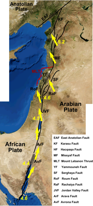
The Dead Sea Transform (DST) fault system, also sometimes referred to as the Dead Sea Rift, is a series of faults that run for about 1,000 km from the Marash triple junction to the northern end of the Red Sea Rift. The fault system forms the transform boundary between the African plate to the west and the Arabian plate to the east. It is a zone of left lateral (sinistral) displacement, signifying the relative motions of the two plates. Both plates are moving in a general north-northeast direction, but the Arabian plate is moving faster, resulting in the observed left lateral motions along the fault of approximately 107 km at its southern end. A component of extension is also present in the southern part of the transform, which has contributed to a series of depressions, or pull-apart basins, forming the Gulf of Aqaba, Dead Sea, Sea of Galilee, and Hula basins. A component of shortening affects the Lebanon restraining bend, leading to uplift on both sides of the Beqaa valley. There is local transtension in the northernmost part of the fault system, forming the Ghab pull-apart basin. The southern part of the fault system runs roughly along the political border of Lebanon and Israel on its western side, and southern Syria and Jordan on the eastern side.

The Gulf of Suez Rift is a continental rift zone that was active between the Late Oligocene and the end of the Miocene. It represented a continuation of the Red Sea Rift until break-up occurred in the middle Miocene, with most of the displacement on the newly developed Red Sea spreading centre being accommodated by the Dead Sea Transform. During its brief post-rift history, the deepest part of the remnant rift topography has been filled by the sea, creating the Gulf of Suez.
The Brawley Seismic Zone (BSZ), also known as the Brawley fault zone, is a predominantly extensional tectonic zone that connects the southern terminus of the San Andreas Fault with the Imperial Fault in Southern California. The BSZ is named for the nearby town of Brawley in Imperial County, California, and the seismicity there is characterized by earthquake swarms.
The Cerro Prieto Fault is a transform fault located in far northern Baja California. It runs between the Cerro Prieto spreading center located southwest of Mexicali, and the Wagner Basin, another spreading center which lies under the Gulf of California. These spreading centers are part of the East Pacific Rise, the northern leg of which has formed the Gulf of California by steadily rifting the Baja California peninsula away from the mainland of Mexico.
Wagner Basin is a submarine depression in the far northern part of the Gulf of California. The basin is currently tectonically active. It is the northernmost underwater depression associated with the East Pacific Rise and is located near the southern end of the Cerro Prieto fault. The depression is a result of subsidence caused by the extensional forces imparted by a spreading center. The Wagner Basin is bounded on its eastern side by the Wagner Fault, a primarily normal fault which dips approximately 60 degrees to the northwest. The western side of the basin is bounded by another normal fault, the Consag Fault which dips in a direction opposite the Wagner Fault. The seabed between these faults is sinking. The basin is linked to the dextral Cerro Prieto Fault at its north end.
The Delfin Basin is a pair of interconnected submarine depressions located on the seabed of the northern Gulf of California. The northernmost of these is called the Upper Delfin Basin while the southernmost is called the Lower Delfin Basin. Both of these features are areas of subsidence caused by extensional forces imparted by a spreading center associated with the East Pacific Rise. The two basins are linked by a short transform fault which was the apparent source of an earthquake of magnitude 5.5 on November 26, 1997.
The Guaymas Fault, named for the city of Guaymas, Sonora, Mexico, is a major right lateral-moving transform fault which runs along the seabed of the Gulf of California. It is an integral part of the Gulf of California Rift Zone, the northern extremity of the East Pacific Rise. The Guaymas Fault runs from the San Pedro Martir Basin located at the southern end of the San Lorenzo Fault, and extends southward to the Guaymas Basin, a heavily sedimented rift which includes both continental and oceanic crust and contains numerous hydrothermal vents.

The Gulf of California Rift Zone (GCRZ) is the northernmost extension of the East Pacific Rise which extends some 1,300 km (800 mi) from the mouth of the Gulf of California to the southern terminus of the San Andreas Fault at the Salton Sink.
The Tamayo Fault is a major right lateral-moving transform fault located on the seabed at the mouth of the Gulf of California. The fault is the southernmost transform in the Gulf of California Rift Zone. The fault links the Rivera Ridge segment of the East Pacific Rise in the south with the Alarcon Basin in the north.
The Alarcon Basin is a submarine depression located on the seabed at the southern end of the Gulf of California. The basin results from the activity of the southernmost spreading center in the Gulf. This spreading center has also produced the southernmost oceanic rift in the Gulf of California Rift Zone, the Alarcon Rise. The basin and rise are linked to the Tamayo Fault to the south, and the Pescadero Fault in the north.
The Carmen Fault is a right lateral-moving transform fault located on the seafloor of the southern Gulf of California. It links the Guaymas Basin to the north with the Carmen Basin to the south. All these features are part of the Gulf of California Rift Zone, the northern extension of the East Pacific Rise.
The Farallon Fault is a right lateral-moving transform fault located on the seafloor of the southern Gulf of California. It links the Carmen Basin to the north with the Farallon Basin to the south. All these features are part of the Gulf of California Rift Zone, the northern extension of the East Pacific Rise.
The Pescadero Fault is a right lateral-moving transform fault located on the seafloor of the southern Gulf of California. It links the Pescadero Basin to the north with the Alarcon Basin to the south. All these features are part of the Gulf of California Rift Zone, the northern extension of the East Pacific Rise.
The Pescadero Basin is a submarine depression located on the seabed at the southern end of the Gulf of California off the coast of the Mexican state of Sinaloa. The basin results from the activity of one of the several spreading centers in the Gulf. The basin is linked to the Pescadero Fault to the south, and the Atl Fault in the north, two of the transform faults of the Gulf of California Rift Zone, i. e. the northern extension of the eastern Pacific Ridge.

The Salton Trough is an active tectonic pull-apart basin, or graben. It lies within the Imperial, Riverside, and San Diego counties of southeastern California and extends south of the Mexico–United States border into the state of Baja California.
A transfer zone in geology is an area where deformational strain is transferred from one structural element to another typically from fault to fault in rift systems. Therefore, listric faults and monoclinal folds in the hanging wall are typical structures linked by transfer zones; however, complexities do exist. The terms interbasin and intrabasin transfer zones have been proposed to delineate the magnitude of the transfer zone. Transfer zones can be described according to the fault dip directions; synthetic or conjugate and according to their deformation style; convergent or divergent. Transfer zones can be farther identified by its maturity or ; whether the major fault relationship is approaching, overlapping, collateral or collinear. Since transfer zones are normally found in extensional settings many studies have been done within the East African Rift system and the Gulf of Suez rift system. Transfer zones have also played a role in hydrocarbon exploration and extraction within the Albertine graben.

The Gulf of Corinth basin, or Corinth rift, is an active extensional marine sedimentary basin thought to have started deforming during the late Miocene – Pleistocene epoch. The dimensions of the Gulf of Corinth are approximately 105 km long and 30 km wide with a basement depth of 3 km at its center. This half-graben basin is formed by a N100°E-oriented rift which separates the Peloponnese peninsula from the continental mainland of Greece. Currently the Corinth rift is opening at rate of 10–15 mm/yr, with respect to the Eurasia Plate. The basin is bounded by the Peloponnese highlands to the south and the westward-moving Anatolian Fault to the north. Major and minor fault planes make up the north and south margins, and its north-south extension is due to activity along an E-W to NW-SE oriented coastal southern margin. The basin's active and inactive faults create associated syn-rift sediment fill. These aspects provide a unique opportunity for scientists to study the tectonic and stratigraphic development of a rift, while further understanding how a basin is actually made.
References
| | This Mexico location article is a stub. You can help Wikipedia by expanding it. |
| | This article about a regional geological feature is a stub. You can help Wikipedia by expanding it. |