Related Research Articles
Ebor is a village on Waterfall Way on the Northern Tablelands in New South Wales, Australia. It is situated about 80 km (50 mi) east of Armidale and about a third of the way between Armidale and the coast. Dorrigo to the east is 46 kilometres (29 mi) away with the Coffs Coast 55 kilometres (34 mi) away along Waterfall Way. In the 2021 census, Ebor's zone had a population of 149.

Macon County is a county located in the U.S. state of North Carolina. As of the 2020 census, the population was 37,014. Its county seat is Franklin.

Tamborine National Park is a protected area split between the City of Gold Coast and the Scenic Rim Region in South East Queensland, Australia, 67.5 km (41.9 mi) by road south of Brisbane.

Stanbury is a village and former civil parish, now in the parish of Haworth and Stanbury, in the metropolitan borough of the City of Bradford in West Yorkshire, England. In 1931 the parish had a population of 453. The name Stanbury translates as Stone Fort from Old English.
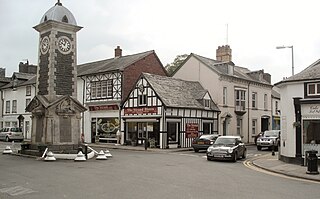
Rhayader is a market town and community in Powys, Wales, within the historic county of Radnorshire. The town is 20 miles (32 km) from the source of the River Wye on Plynlimon, the highest point of the Cambrian Mountains, and is located at the junction of the A470 road and the A44 road 13 miles (21 km) north of Builth Wells and 30 miles (48 km) east of Aberystwyth.
Serian is a town, and the capital of the Serian separated on 11 April 2015 from Samarahan Division, Sarawak, Malaysia. It is located about 40 miles (64 km) from Kuching. Sub-district headquarters towns are Balai Ringin and Tebedu.

Cloudland Canyon State Park is a 3,485 acres (14.10 km2) Georgia state park located near Trenton and Cooper Heights on the western edge of Lookout Mountain. One of the largest and most scenic parks in Georgia, it contains rugged geology, and offers visitors a range of vistas across the deep gorge cut through the mountain by Sitton Gulch Creek, where the elevation varies from 800 to over 1,800 feet. Views of the canyon can be seen from the picnic area parking lot, in addition to additional views located along the rim trail. At the bottom of the gorge, two waterfalls cascade across layers of sandstone and shale, ending in small pools below.
Hillcrest is a town in the KwaZulu-Natal province of South Africa that forms part of the eThekwini Metropolitan Municipality and is situated approximately 32 km north-west of Durban and 53 km south-east of Pietermaritzburg.
Waterfall Gully is an eastern suburb of the South Australian capital city of Adelaide. It is located in the foothills of the Mount Lofty Ranges around 5 km (3.1 mi) east-south-east of the Adelaide city centre. For the most part, the suburb encompasses one long gully with First Creek at its centre and Waterfall Gully Road running adjacent to the creek. At the southern end of the gully is First Falls, the waterfall for which the suburb was named. Part of the City of Burnside, Waterfall Gully is bounded to the north by the suburb of Burnside, from the north-east to south-east by Cleland National Park, to the south by Crafers West, and to the west by Leawood Gardens and Mount Osmond.

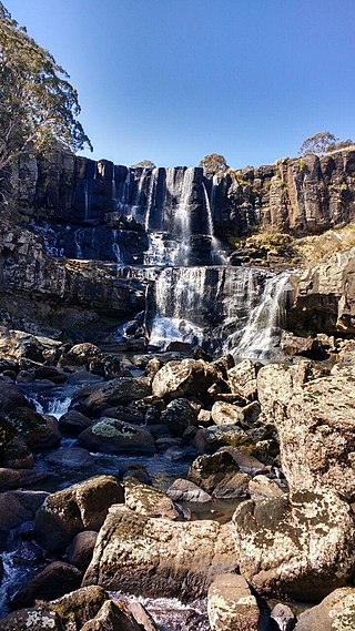
Waterfall Way is a 170-kilometre (110 mi) country road in the Northern Tablelands region of New South Wales, Australia, linking Raleigh on the state's North Coast to Armidale. The route passes through some of New South Wales' most scenic countryside and has become well known as its best and Australia's third most beautiful tourist drive. Seven national parks, of which three are listed as World Heritage Areas by UNESCO and form part of the Gondwana Rainforests of Australia, are located on or close to the route. Dorrigo National Park encompasses the waterfalls that give the route its name.

Damanjodi is a town located in the Koraput district of Odisha, India. As of 2001 census, its population was 8,469. The town was founded as a residential area for employees of the National Aluminium Company (NALCO), a company that was established to harness the bauxite-rich deposits of the Panchpatmali Range. Damanjodi contains the NALCO Township, a residential area for NALCO employees, Mathalput, a semi-urban neighborhood with shops, and Bhejaput, a shopping complex. The population is considered cosmopolitan in nature with employees from all over India and locals from the tribal region.

Jawhar is a city and a municipal council in Palghar district of Maharashtra state in Konkan division of India. Jawhar was a capital city of the erstwhile Koli princely state of Jawhar. Situated in the ranges of the Western Ghats, Jawhar is known for its picturesque setting and a vibrant cultural heritage. It is one of the few remaining tribal regions of Maharashtra and is known for its vibrant Warli painting that are a characteristic landmark of this place. Established in 1918, Jawhar is one of the oldest municipal councils in the state of Maharashtra and tourist spot near Mumbai.
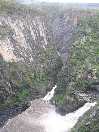
The Apsley Falls are two waterfalls on the Apsley River in the Northern Tablelands region of New South Wales, Australia. The falls are located about 20 kilometres (12 mi) east of Walcha, and 1 kilometre off the Oxley Highway in a deep gorge, that is part of the Oxley Wild Rivers National Park. They are the first falls in a succession of dramatic drops in an area that has some of the most remarkable scenery in Eastern Australia. The first drop of the falls is about 65 metres (213 ft) in depth, and the second, which is about 800 metres (2,625 ft) further on, plummets 58 metres (190 ft) to the bottom of the gorge.
Serai Niamat Khan or Sarai Niamat Khan is one of the 44 union councils of the Haripur District in the Khyber Pakhtunkhwa province of Pakistan. It is divided into smaller areas including Mohallah Khu, Jora Pind, Moriyan, Najeeb Abad, and Mohalla Ziarat.

The 2008 Ziarat earthquakes hit the Pakistani province of Balochistan on October 29 with a moment magnitude of 6.4. The US Geological Survey reported that the first earthquake occurred 60 km (37 mi) north of Quetta and 185 km (115 mi) southeast of the Afghanistan city of Kandahar at 04:09 local time at a depth of 15 km (9.3 mi), at 30.653°N, 67.323°E. It was followed by another shallower magnitude 6.4 earthquake at a depth of 14 km (8.7 mi) approximately 12 hours after the initial shock, at 30.546°N, 67.447°E. 215 people were confirmed dead. More than 200 were injured, and 120,000 were rendered homeless. Qamar Zaman Chaudhry, director general of Pakistan Meteorological Department, stated the quake epicenter was 70 miles (110 km) north of Quetta, and about 600 km (370 mi) southwest of Islamabad.
Sandeman Tangi is a village and union council of Ziarat District in the Balochistan province of Pakistan. The village was named after British administrator, Robert Groves Sandeman. It is 4 km from Ziarat and contains a dramatic waterfall cascading down the rocks which is an attraction for visitors. The waterfall was earlier known as Droond Tangai. Many believed that ghosts lived there.
Kuchlak, also Kuchlagh, sometimes mistakenly referred to as Kachlak, is a town near Quetta, in the province of Balochistan, Pakistan. It is governed by a union council in Chiltan Town, Quetta. Kuchlak is home to Halaqa Number 61, one of the largest halaqas in Quetta. Kuchlak is well known for summer fruits such as apples and peaches; however, soil aridity is a problem. Vegetables grown in the valley include tomatoes, potatoes, onions and turnips.

Ziarat is a village in the Central District of Gorgan County, Golestan Province, Iran. At the 2006 census its population was 1,964, in 478 families.

Ziarat is a district in the north of Balochistan province of Pakistan. Ziarat town is the headquarters of the district, the sub-division, and also of the tehsil. The highest peak of Khalifat Hills, at an altitude of 11,400 feet (3,500 m), is located in Ziarat district.
Kandia is a tehsil located in the Upper Kohistan District of Khyber Pakhtunkhwa, Pakistan. It consists of five union councils: Karang, Thoti, Kareen, Jashoi and Gabrial. The population is 84,055 according to the 2017 census.
References
- ↑ "List of all Names of all Union Councils and Tehsils". Archived from the original on 2008-11-20. Retrieved 2008-11-19.
| | This Balochistan location article is a stub. You can help Wikipedia by expanding it. |