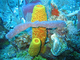
Demosponges are the most diverse class in the phylum Porifera. They include 76.2% of all species of sponges with nearly 8,800 species worldwide. They are sponges with a soft body that covers a hard, often massive skeleton made of calcium carbonate, either aragonite or calcite. They are predominantly leuconoid in structure. Their "skeletons" are made of spicules consisting of fibers of the protein spongin, the mineral silica, or both. Where spicules of silica are present, they have a different shape from those in the otherwise similar glass sponges. Some species, in particular from the Antarctic, obtain the silica for spicule building from the ingestion of siliceous diatoms.
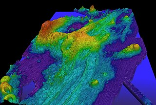
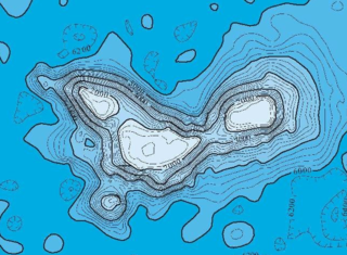
Axial Seamount is a seamount and submarine volcano located on the Juan de Fuca Ridge, approximately 480 km (298 mi) west of Cannon Beach, Oregon. Standing 1,100 m (3,609 ft) high, Axial Seamount is the youngest volcano and current eruptive center of the Cobb–Eickelberg Seamount chain. Located at the center of both a geological hotspot and a mid-ocean ridge, the seamount is geologically complex, and its origins are still poorly understood. Axial Seamount is set on a long, low-lying plateau, with two large rift zones trending 50 km (31 mi) to the northeast and southwest of its center. The volcano features an unusual rectangular caldera, and its flanks are pockmarked by fissures, vents, sheet flows, and pit craters up to 100 m (328 ft) deep; its geology is further complicated by its intersection with several smaller seamounts surrounding it.
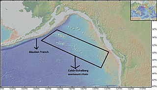
The Cobb-Eickelberg seamount chain is a range of undersea mountains formed by volcanic activity of the Cobb hotspot located in the Pacific Ocean. The seamount chain extends to the southeast on the Pacific Plate, beginning at the Aleutian Trench and terminating at Axial Seamount, located on the Juan de Fuca Ridge.The seamount chain is spread over a vast length of approximately 1800 km. The location of the Cobb hotspot that gives rise to these seamounts is 46° N -130° W. The Pacific plate is moving to the northwest over the hotspot, causing the seamounts in the chain to decrease in age to the southeast. Axial is the youngest seamount and is located approximately 480 km west of Cannon Beach, Oregon. The most studied seamounts that make up this chain are Axial, Brown Bear, Cobb, and Patton seamounts. There are many other seamounts in this chain which have not been explored.
Cobb Seamount is a seamount and guyot located 500 km (310 mi) west of Grays Harbor, Washington, United States. Cobb Seamount is one of the seamounts in the Cobb–Eickelberg Seamount chain, a chain of underwater volcanoes created by the Cobb hotspot that terminates near the coast of Alaska. It lies just west of the Cascadia subduction zone, and was discovered in August 1950 by the U.S. Fish and Wildlife Service fisheries research vessel R/V John N. Cobb. By 1967, over 927 km (576 mi) of soundings and dozens of samples from the seamount had been collected.

Davidson Seamount is a seamount located off the coast of Central California, 80 mi (129 km) southwest of Monterey and 75 mi (121 km) west of San Simeon. At 26 mi (42 km) long and 8 mi (13 km) wide, it is one of the largest known seamounts in the world. From base to crest, the seamount is 7,480 ft (2,280 m) tall, yet its summit is still 4,101 ft (1,250 m) below the sea surface. The seamount is biologically diverse, with 237 species and 27 types of deep-sea coral having been identified.

The Anton Dohrn Seamount is a guyot in the Rockall Trough in the northeast Atlantic. It is 1.8 kilometres (1.1 mi) high and is topped with pinnacles, one of which reaches a depth of 530 metres (1,740 ft). Away from the flat top upon which the pinnacles rest, the slopes fall off steeply into the Rockall Trough and a moat in the sediment that surrounds the seamount.

Patton Seamount is a prominent seamount in the Cobb–Eickelberg Seamount chain in the Gulf of Alaska. Located 166 nmi east of Kodiak Island and reaching to within 160 m (520 ft) of the ocean surface, Patton is one of the largest seamounts in the Cobb–Eickelberg Seamount chain. It was originally created near the coast of Oregon by the Cobb hotspot 33 million years ago, and was moved to its present location by tectonic plate movement. Patton is one of the most well-understood seamounts, as a major expedition using DSV Alvin in 1999 and another in 2002 helped define the scope of the seamount's biological community. Like other large seamounts, Patton acts as an ecological hub for sea life. Dives have revealed that the volcano is heavily encrusted in sea life of various forms, including sea stars, corals, king crabs, demersal rockfish, and other species.
Farrea truncata is a species of sea sponge first found at the bottom of shelf, canyon and seamounts of the west coast of Washington, British Columbia and the Gulf of Alaska.

Musicians Seamounts are a chain of seamounts in the Pacific Ocean, north of the Hawaiian Ridge. There are about 65 seamounts, some of which are named after musicians. These seamounts exist in two chains, one of which has been attributed to a probably now-extinct hotspot called the Euterpe hotspot. Others may have formed in response to plate tectonics associated with the boundary between the Pacific Plate and the former Farallon Plate.
Vema Seamount is a seamount in the South Atlantic Ocean. Discovered in 1959 by a ship with the same name, it lies 1,600 kilometres (1,000 mi) from Tristan da Cunha and 1,000 kilometres (620 mi) northwest of Cape Town. The seamount has a flat top at a mean depth of 73 metres which was eroded into the seamount at a time when sea levels were lower; the shallowest point lies at 26 metres depth. The seamount was formed between 15-11 million years ago, possibly by a hotspot.

Geodia megastrella is a species of sponge in the family Geodiidae. It is a type of demosponge found in the deep temperate waters of the North Atlantic Ocean. It has characteristic stellar-shaped large spicules coined 'megastrellum', hence its name. The species was first described by Henry John Carter in 1876, after dredging it up aboard H.M.S. 'Porcupine', near the Cape St. Vincent in Portugal.
Ioah Guyot is a seamount in the Pacific Ocean, close to the Marshall Islands. Part of the Magellan Seamounts, it is a shield volcano that has erupted alkali basalt and hawaiite 87 million years ago, but may have continued erupting into the Miocene. During the Cretaceous, reefs developed on the guyot.

Vesteris Seamount, also known as Vesteris Bank, is a seamount in the Greenland Sea of the North Atlantic Ocean between Greenland and Norway. It lies north of Jan Mayen and rises from 41–43 million years old ocean crust. The reasons for the volcanic activity at Vesteris are unclear and may involve lithospheric processes.

Ita Mai Tai is a Cretaceous-early Cenozoic seamount northwest of the Marshall Islands and north of Micronesia. One among a number of seamounts in the Pacific Ocean, it is part of the Magellan Seamounts which may have a hotspot origin although Ita Mai Tai itself may not have formed on a hotspot.

Vailuluʻu is a volcanic seamount discovered in 1975. It rises from the sea floor to a depth of 593 m (1,946 ft) and is located between Taʻu and Rose islands at the eastern end of the Samoa hotspot chain. The basaltic seamount is considered to mark the current location of the Samoa hotspot. The summit of Vailuluʻu contains a 2 km wide, 400 m deep oval-shaped caldera. Two principal rift zones extend east and west from the summit, parallel to the trend of the Samoan hotspot. A third less prominent rift extends southeast of the summit.

Tropic Seamount is a Cretaceous seamount, part of the Canary Islands Seamount Province. It is located southwest of the Canary Islands, north of Cape Verde and west of Morocco. It is one of a number of seamounts in this part of the Atlantic Ocean, probably formed by volcanic processes triggered by the proximity to the African continent. Tropic Seamount is located at a depth of 970 metres (3,180 ft) and has a summit platform with an area of 120 square kilometres (46 sq mi).
Hebrides Terrace Seamount is a seamount in the Atlantic Ocean, west-southwest from the Hebrides, Scotland. It formed through volcanism during the early Cenozoic in the Rockall Trough 60 million to 67 million years ago and afterwards sank below sea level. Presently, it is a flat-topped underwater mountain that rises to about 980 metres depth. "Coral gardens" that host a number of animals are found on its slopes.

Coral Patch Seamount is a seamount between Madeira and mainland Portugal in the North Atlantic Ocean. It is an elongated 120 kilometres (75 mi) long and 70 kilometres (43 mi) wide mountain that rises to a depth of about 645 metres (2,116 ft), with nine volcanic cones on its summit. It has steeper southern slopes and a gentle northern slope. To its west lies Ampére Seamount, and together with several neighbouring seamounts it is one of the Horseshoe Seamounts.

Farrea is a genus of glass sponges in the family Farreidae.
Kemp Caldera and Kemp Seamount form a submarine volcano south of the South Sandwich Islands, in a region where several seamounts are located. The seamount rises to a depth of 80 metres (260 ft) below sea level; the caldera has a diameter of 8.3 by 6.5 kilometres and reaches a depth of 1,600 metres (5,200 ft). The caldera contains several Hydrothermal vents, including white smokers and diffuse venting areas, which are host to chemolithotrophic ecological communities. The seamount and caldera, which were discovered by seafloor mapping in 2009, are part of the South Georgia and the South Sandwich Islands Marine Protected Area.