
Worcester is the second-most populous city in the U.S. state of Massachusetts and the 114th most populous city in the United States. Named after Worcester, England, the city had 206,518 people at the 2020 census, also making it the second-most populous city in New England, after Boston. Worcester is about 40 miles (64 km) west of Boston, 50 miles (80 km) east of Springfield, and 40 miles (64 km) north-northwest of Providence. Because it is near the geographic center of Massachusetts, Worcester is known as the "Heart of the Commonwealth"; a heart is the official symbol of the city. Worcester is the historical seat of Worcester County.

The Massachusetts Turnpike is a controlled-access toll highway in the US state of Massachusetts that is maintained by the Massachusetts Department of Transportation (MassDOT). It is concurrent with the entirety of Interstate 90 (I-90) within the state, and is the longest Interstate Highway in Massachusetts, spanning 138 miles (222 km) along an east–west axis.
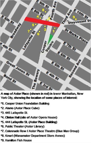
Astor Place is a street in NoHo/East Village, in the lower part of the New York City borough of Manhattan. It is divided into two sections: One segment runs from Broadway in the west to Lafayette Street, and the other runs from Fourth to Third Avenues. The street encompasses two plazas at the intersection with Cooper Square, Lafayette Street, Fourth Avenue, and Eighth Street – Alamo Plaza and Astor Place Station Plaza. "Astor Place" is also sometimes used for the neighborhood around the street. It was named for John Jacob Astor, soon after his death in 1848. A $21 million reconstruction to implement a redesign of Astor Place began in 2013 and was completed in 2016.
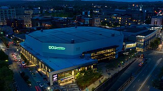
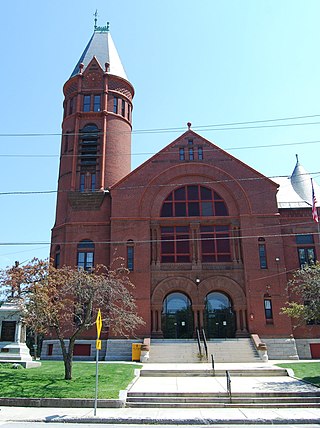
The DCU Center is an indoor arena and convention center complex in downtown Worcester, Massachusetts. The facility hosts a variety of events, including concerts, sporting events, family shows, conventions, trade-shows and meetings. It is owned by the City of Worcester and managed by ASM Global, a private management firm for public assembly facilities.

The Framingham/Worcester Line of the MBTA Commuter Rail system runs west from Boston, Massachusetts, to Worcester, Massachusetts, through the MetroWest region, serving 18 station stops in Boston, Newton, Wellesley, Natick, Framingham, Ashland, Southborough, Westborough, Grafton, and Worcester. It is the third-longest and third-busiest line in the MBTA Commuter Rail system. Service on the line is a mix of local and express trains serving Worcester plus short-turn Framingham locals.

The Pittsburgh Light Rail is a 26.2-mile (42.2 km) light rail system in Pittsburgh, Pennsylvania, and surrounding suburbs. It operates as a deep-level subway in Downtown Pittsburgh, but runs mostly at-grade in the suburbs south of the city. The system is largely linear in a north-south direction, with one terminus near Pittsburgh's central business district and two termini in the South Hills. The system is owned and operated by Pittsburgh Regional Transit.
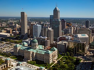
Downtown Indianapolis is a neighborhood area and the central business district of Indianapolis, Indiana, United States. Downtown is bordered by Interstate 65, Interstate 70, and the White River, and is situated near the geographic center of Marion County. Downtown has grown from the original 1821 town plat—often referred to as the Mile Square—to encompass a broader geographic area of central Indianapolis, containing several smaller historic neighborhoods.
Stonebridge Press, Inc. is a privately held newspaper company based in Southbridge, Massachusetts. It was formed October 27, 1995, to operate the newspapers acquired through the purchase of a various newspapers.

Worcester Plaza is a building located in downtown Worcester, Massachusetts at 446 Main Street. Designed by Kevin Roche John Dinkeloo and Associates, it was completed in 1974, and is currently tied with The 6Hundred as the tallest building in Worcester. It stands 289 feet (88 m) tall, is 24 stories high, and has 244,000 square feet (22,700 m2) of total floor space. Its façade is completely glass, similar to the 790-foot (240 m) John Hancock Tower in nearby Boston. The tower was formerly known as the Worcester County National Bank Tower

Mercantile Center is a high-rise building located at 100 Front Street in Downtown Worcester, Massachusetts. The former Worcester Center complex, comprising 100 Front Street and the adjacent nine story tower at 120 Front Street were named Mercantile Center by its owner, Franklin Realty Advisors, in early 2016.

Doherty Memorial High School is a public high school located in Worcester, Massachusetts, United States. It opened its doors in the fall of 1966, replacing two closing schools: Worcester Classical High School and Worcester Commerce High School.

Stevens' Building is a historic commercial building located at 24–44 Southbridge Street in downtown Worcester, Massachusetts. It is one of the city's most imposing mid-19th century buildings. The brick building is four stories for most of its length on Southbridge Street, and also presents a finished facade to Burnside Court. The central portion rises to a full five stories with a flat roof, while the north and south sections are four floors with a low pitch roof. The oldest portion of the building was the central portion, built sometime in the 1850s. The Stevens Brothers, manufacturers of wooden architectural building parts, purchased this building c. 1867, extended it northward to Burnside Court, and used it as factory space. By 1870 they had bought the land south of the building, and erected as a freestanding building seven bays of the present building. The two buildings were then joined together later in the 1870s. The fifth floor of the central section was probably added after a fire in the early 1900s.
The Worcester Center Galleria, located in Downtown Worcester, Massachusetts, was a two level shopping mall which originally opened on July 29, 1971, as a part of the Worcester Center urban renewal project. The mall, which connected the 100 Front Street and 120 Front Street office towers, was successful for 20 years until it closed following a series of store vacancies. The mall re-opened in 1994 as a short-lived outlet center called Worcester Common Fashion Outlets, finally closing in 2006. The mall was demolished and redeveloped into a project called CitySquare.
The Cambridge Street School is a historic former school building at 510 Cambridge Street in Worcester, Massachusetts. Built in 1869 and twice enlarged substantially, it is notable for including the only surviving unaltered Second Empire school building in the city. The building served Worcester's public school students until 1976; the city sold the building in 1978. It now serves as a transitional housing facility for homeless families. The building was listed on the National Register of Historic Places in 1980.

The Worcester Historical Museum, located in downtown Worcester, Massachusetts, was founded in 1875 as the Worcester Society of Antiquity. This museum is the only institution in the area devoted entirely to local history and artifacts. The scope of their collection ranges from colonial to twentieth-century, encompassing manuscripts, textiles, paintings, and ceramics. The museum is made up of permanent and temporary exhibits, a research library, and currently owns and operates the local Salisbury Mansion. The library maintains more than 7,000 titles.

The 2011 New England Tornado Outbreak was a tornado outbreak on June 1, 2011, that impacted the states of Massachusetts and Maine in New England. A total of six tornadoes touched down in both western Massachusetts and western Maine. The strongest, often referred to as the Springfield Tornado, was a long-track, high-end EF3 tornado that caused significant damage to the city of Springfield, Massachusetts as well as several adjacent cities and towns. By the end of the day, three people had been killed, at least 200 were injured, and over 500 families were left homeless.
Southbridge is a city in Worcester County, Massachusetts, United States. The population was 17,740 at the 2020 census. Although Southbridge has a city form of government, it is legally known as the Town of Southbridge.
The city of Worcester, Massachusetts consists of six regions: North Worcester, West Side, East Side, Central City, Downtown, and South Worcester. It can be further subdivided into smaller neighborhoods:
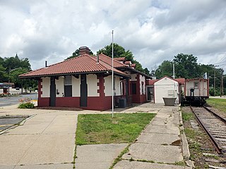
The Southbridge Branch was a railway line in Connecticut and Massachusetts, United States. It ran 16.9 miles (27.2 km) between Southbridge, Massachusetts and East Thompson, Connecticut, via Webster, Massachusetts. Originally planned to be part of the Southbridge and Blackstone Railroad, it was ultimately built in 1866–67 by the Boston, Hartford and Erie Railroad. It became part of the New York and New England Railroad in 1875, and the New York, New Haven and Hartford Railroad in 1898. Passenger service ended in 1930, and the eastern portion of the line was abandoned in 1937. The western half continued to be used for freight service; it passed to Penn Central in 1969, and to the Providence and Worcester Railroad (P&W) in 1976 as the Southbridge Running Track. The P&W stopped serving the line in the 1980s, but did not abandon it until 2004. Much of the western half of the line in Massachusetts has been converted to the Quinebaug Valley Rail Trail.

The 6Hundred is a mixed-use skyscraper located in downtown Worcester, Massachusetts. It stands 289 feet (88 m) tall, is 24 stories high, and has 247,000 square feet (22,900 m2) of total floor space, including ground floor office space and 206 rental apartments. It was completed in 1991, and is currently tied with Worcester Plaza as the tallest building in Worcester. It was briefly known as The Tower at Franklin Square during planning and construction.


