Ferndale Airfield

Last updated
Ferndale Airfield
Summary
Airport type Public
Owner Flathead Municipal Airport Authority
Serves Bigfork, Montana
Elevation  AMSL 3,072 ft / 936 m
Coordinates 48°03′38″N114°00′04″W / 48.06056°N 114.00111°W / 48.06056; -114.00111 Coordinates: 48°03′38″N114°00′04″W / 48.06056°N 114.00111°W / 48.06056; -114.00111
Map
USA Montana relief location map.jpg
Airplane silhouette.svg
53U
Location of airport in Montana
Runways
Direction Length Surface
ft m
15/33 3,500 1,067 Turf
Statistics (2005)
Aircraft operations 10,700
Based aircraft 36

Ferndale Airfield( FAA LID : 53U) is a public use airport in Flathead County, Montana, United States. [1] It is owned by the Flathead Municipal Airport Authority and located three  nautical miles (6  km) northeast of the central business district of Bigfork, Montana. [1]

Federal Aviation Administration United States Government agency dedicated to civil aviation matters

The Federal Aviation Administration (FAA) is a governmental body of the United States with powers to regulate all aspects of civil aviation in that nation as well as over its surrounding international waters. Its powers include the construction and operation of airports, air traffic management, the certification of personnel and aircraft, and the protection of U.S. assets during the launch or re-entry of commercial space vehicles. Powers over neighboring international waters were delegated to the FAA by authority of the International Civil Aviation Organization.

A location identifier is a symbolic representation for the name and the location of an airport, navigation aid, or weather station, and is used for manned air traffic control facilities in air traffic control, telecommunications, computer programming, weather reports, and related services.

Airport location where aircraft take off and land

An airport is an aerodrome with extended facilities, mostly for commercial air transport. Airports often have facilities to store and maintain aircraft, and a control tower. An airport consists of a landing area, which comprises an aerially accessible open space including at least one operationally active surface such as a runway for a plane to take off or a helipad, and often includes adjacent utility buildings such as control towers, hangars and terminals. Larger airports may have airport aprons, taxiway bridges, air traffic control centres, passenger facilities such as restaurants and lounges, and emergency services. In some countries, the US in particular, they also typically have one or more fixed-base operators, serving general aviation.

Contents

Facilities and aircraft

Ferndale Airfield covers an area of 35 acres (14 ha) at an elevation of 3,072 feet (936 m) above mean sea level. It has one runway designated 15/33 with a turf surface measuring 3,500 by 95 feet (1,067 x 29 m). [1]

Acre unit of area

The acre is a unit of land area used in the imperial and US customary systems. It is traditionally defined as the area of one chain by one furlong, which is exactly equal to 10 square chains, ​1640 of a square mile, or 43,560 square feet, and approximately 4,047 m2, or about 40% of a hectare. Based upon the International yard and pound agreement of 1959, an acre may be declared as exactly 4,046.8564224 square metres. The acre is a statute measure in the United States and was formerly one in the United Kingdom and almost all countries of the former British Empire, although informal use continues.

Hectare metric unit of area

The hectare is an SI accepted metric system unit of area equal to a square with 100-metre sides, or 10,000 m2, and is primarily used in the measurement of land. There are 100 hectares in one square kilometre. An acre is about 0.405 hectare and one hectare contains about 2.47 acres.

Elevation Height of a geographic location above a fixed reference point

The elevation of a geographic location is its height above or below a fixed reference point, most commonly a reference geoid, a mathematical model of the Earth's sea level as an equipotential gravitational surface . The term elevation is mainly used when referring to points on the Earth's surface, while altitude or geopotential height is used for points above the surface, such as an aircraft in flight or a spacecraft in orbit, and depth is used for points below the surface.

For the 12-month period ending August 24, 2005, the airport had 10,700 aircraft operations, an average of 29 per day: 99% general aviation and 1% air taxi. At that time there were 36 aircraft based at this airport: 97% single-engine and 3% glider. [1]

General aviation civil use of aircraft excluding commercial transportation

General Aviation (GA) represents the 'private transport' and recreational flying component of aviation.

Air taxi on-demand commercial air transportation, particularly of smaller quantities of passenger or cargo by aeroplane or helicopter

An air taxi is a small commercial aircraft which makes short flights on demand.

Aircraft engine Engine designed for use in powered aircraft

An aircraft engine is a component of the propulsion system for an aircraft that generates mechanical power. Aircraft engines are almost always either lightweight piston engines or gas turbines, except for small multicopter UAVs which are almost always electric aircraft.

See also

Related Research Articles

Glasgow Valley County Airport airport in Valley County, Montana, United States

Glasgow Valley County Airport IATA: GGW, ICAO: KGGW, FAA LID: GGW) is a public airport a mile northeast of Glasgow, in Valley County, Montana. It is served by one airline, subsidized by the Essential Air Service program.

Great Falls International Airport

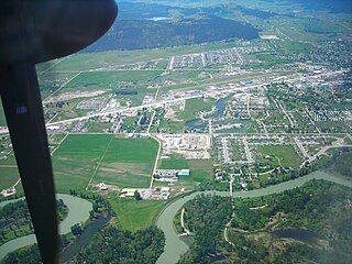
Great Falls International Airport is a public/military airport in city limits three miles southwest of central Great Falls in Cascade County, Montana.

Bozeman Yellowstone International Airport airport

Bozeman Yellowstone International Airport is located in Belgrade eight miles (13 km) northwest of Bozeman, in Gallatin County, Montana. Owned by the Gallatin Airport Authority, the airport became the busiest airport in Montana in 2013.

Helena Regional Airport

Helena Regional Airport is a public airport two miles northeast of Helena, in Lewis and Clark County, Montana. It is owned by the Helena Regional Airport Authority.

Yakima Air Terminal

Yakima Air Terminal is a public airport three miles south of Yakima, in Yakima County, Washington. Owned by the City of Yakima, it is used for general aviation and commercial air service. Yakima is served by one scheduled air carrier and two non-scheduled carriers. Sun Country Airlines provide charter flights to Laughlin, NV and Xtra Airways provide charter flights to Wendover, NV.

Ormond Beach Municipal Airport

Ormond Beach Airport, also known as Ormond Beach Municipal Airport, is a general aviation airport located 3 miles (4.8 km) to the northwest of the city of Ormond Beach in Volusia County, Florida, USA.

Allen Army Airfield

Allen Army Airfield is a public and military use airport serving Fort Greely and located three miles (5 km) south of the central business district of Delta Junction, a city in the Southeast Fairbanks Census Area of the U.S. state of Alaska. It is owned by the United States Army, which has an agreement with the City of Delta Junction for joint use of the airfield by both military and civilian aircraft.

Madison County Executive Airport

Madison County Executive Airport, also known as Tom Sharp Jr. Field, is a public-use airport in Madison County, Alabama, United States. It is owned by the Madison County Executive Airport Authority and located eight nautical miles (14.80 km) northeast of the central business district of Huntsville. According to the FAA's National Plan of Integrated Airport Systems for 2009–2013, it is categorized as a general aviation facility.

Sonoma Skypark airport in Sonoma, California

Sonoma Skypark is a public-use airport located three nautical miles (6 km) southeast of the central business district of Sonoma, a city in Sonoma County, California, United States. It is privately owned by Sonoma Skypark, Inc.

Albertville Regional Airport

Albertville Regional Airport, also known as Thomas J. Brumlik Field, is a city-owned, public-use airport located three nautical miles southwest of the central business district of Albertville, in Marshall County, Alabama, United States. It was formerly known as Albertville Municipal Airport.

Camden Municipal Airport

Camden Municipal Airport is a city-owned, public-use airport located three nautical miles (6 km) southwest of the central business district of Camden, a city in Wilcox County, Alabama, United States.

Grove Hill Municipal Airport

Grove Hill Municipal Airport is a city-owned public-use airport located two nautical miles southeast of the central business district of Grove Hill, a city in Clarke County, Alabama, United States. According to the FAA's National Plan of Integrated Airport Systems for 2009–2013, it is categorized as a general aviation facility.

Cut Bank Municipal Airport

Cut Bank Municipal Airport is three miles southwest of Cut Bank, in Glacier County, Montana. It is owned by Cut Bank and Glacier County.

Dell Flight Strip

Dell Flight Strip is a public-use airport located one nautical mile northwest of the central business district of Dell, in Beaverhead County, Montana, United States. It is owned by the Montana Department of Transportation Aeronautics Division and provides general aviation service.

Kalispell City Airport

Kalispell City Airport is a city-owned public-use airport located one nautical mile south of the central business district of Kalispell, a city in Flathead County, Montana, United States. This airport is included in the FAA's National Plan of Integrated Airport Systems for 2009–2013, which categorized it as a general aviation facility.

Hot Springs Airport airport in Montana, United States

Hot Springs Airport is a county-owned public-use airport in Sanders County, Montana, United States. It is located two nautical miles (4 km) east of the central business district of Hot Springs, Montana, a town on the Flathead Indian Reservation.

Big Sandy Airport airport

Big Sandy Airport is a public use airport in Chouteau County, Montana, United States. It is owned by the Town of Big Sandy and located one nautical mile (2 km) south of its central business district. This airport is included in the National Plan of Integrated Airport Systems for 2011–2015, which categorized it as a general aviation facility.

Malta Airport (Montana)

Malta Airport is a public use airport located one nautical mile (2 km) northwest of the central business district of Malta, a city in Phillips County, Montana, United States. It is owned by the Phillips County Regional Airport Authority. This airport is included in the National Plan of Integrated Airport Systems for 2011–2015, which categorized it as a general aviation facility.

Turner Airport

Turner Airport is a public use airport in Blaine County, Montana, United States. It is owned by Blaine County and located one nautical mile (2 km) northeast of the central business district of Turner, Montana. This airport is included in the National Plan of Integrated Airport Systems for 2011–2015, which categorized it as a general aviation facility.

Polson Airport

Polson Airport is a public use airport in Lake County, Montana, United States. It is located one nautical mile (2 km) west of the central business district of Polson, a city on the southern shore of Flathead Lake. The airport is owned by the City of Polson and Lake County. It is included in the National Plan of Integrated Airport Systems for 2011–2015, which categorized it as a general aviation facility.

References

  1. 1 2 3 4 5 FAA Airport Master Record for 53U ( Form 5010 PDF ). Federal Aviation Administration. Effective November 15, 2012.
The National Map

The National Map is a collaborative effort of the United States Geological Survey (USGS) and other federal, state, and local agencies to improve and deliver topographic information for the United States. The purpose of the effort is to provide "...a seamless, continuously maintained set of public domain geographic base information that will serve as a foundation for integrating, sharing, and using other data easily and consistently".