Fichtwald

Last updated
Fichtwald
Naundorf55.JPG
Location of Fichtwald within Elbe-Elster district
Fichtwald in EE.pngFalkenbergHeidelandHerzbergHirschfeldMühlbergRückersdorfSchönborn
Germany adm location map.svg
Red pog.svg
Fichtwald
Brandenburg location map.svg
Red pog.svg
Fichtwald
Coordinates: 51°42′00″N13°28′00″E / 51.70000°N 13.46667°E / 51.70000; 13.46667
Country Germany
State Brandenburg
District Elbe-Elster
Municipal assoc. Schlieben
Subdivisions3 Ortsteile
Government
   Mayor (202429) Thomas Wilkert [1]
Area
  Total31.55 km2 (12.18 sq mi)
Elevation
112 m (367 ft)
Population
 (2022-12-31) [2]
  Total599
  Density19/km2 (49/sq mi)
Time zone UTC+01:00 (CET)
  Summer (DST) UTC+02:00 (CEST)
Postal codes
04936
Dialling codes 035361
Vehicle registration EE, FI, LIB

Fichtwald is a municipality in the Elbe-Elster district, in Brandenburg, Germany.

Contents

History

From 1815 to 1944, the constituent localities of Fichtwald was part of the Prussian Province of Saxony. From 1944 to 1945, they were part of the Province of Halle-Merseburg. From 1952 to 1990, they were part of the Bezirk Cottbus of East Germany. On 31 December 2001, the municipality of Fichtwald was formed by merging the municipalities of Hillmersdorf, Naundorf and Stechau.

Demography

Fichtwald: Population development
within the current boundaries (2017) [3]
YearPop.±% p.a.
1875 970    
1890 980+0.07%
1910 960−0.10%
1925 1,001+0.28%
1933 931−0.90%
1939 866−1.20%
1946 1,362+6.68%
1950 1,333−0.54%
1964 1,019−1.90%
1971 1,003−0.23%
1981 943−0.61%
1985 952+0.24%
1989 890−1.67%
1990 883−0.79%
YearPop.±% p.a.
1991 854−3.28%
1992 851−0.35%
1993 841−1.18%
1994 845+0.48%
1995 843−0.24%
1996 833−1.19%
1997 817−1.92%
1998 813−0.49%
1999 813+0.00%
2000 804−1.11%
2001 802−0.25%
2002 780−2.74%
2003 775−0.64%
2004 759−2.06%
YearPop.±% p.a.
2005 735−3.16%
2006 716−2.59%
2007 709−0.98%
2008 703−0.85%
2009 686−2.42%
2010 675−1.60%
2011 660−2.22%
2012 683+3.48%
2013 685+0.29%
2014 678−1.02%
2015 673−0.74%
2016 649−3.57%
2017 625−3.70%

Related Research Articles

<span class="mw-page-title-main">Doberlug-Kirchhain</span> Town in Brandenburg, Germany

Doberlug-Kirchhain is a German town in the district of Elbe-Elster, Lower Lusatia, Brandenburg.

<span class="mw-page-title-main">Mühlberg, Brandenburg</span> Town in Brandenburg, Germany

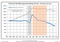
Mühlberg is a town in the Elbe-Elster district, in the southwesternmost part of Brandenburg, Germany. It is located on the right bank of the river Elbe, about halfway between Riesa to the south and Torgau to the northwest. It is about 60 km east of Leipzig. It is accessed by the Bundesstraße 182 on the left bank of the Elbe, connected with the town by a bridge, opened in 2008. Mühlberg consists of the Ortsteile Mühlberg, Altenau, Brottewitz, Fichtenberg, Koßdorf and Martinskirchen.

<span class="mw-page-title-main">Finsterwalde</span> Town in Brandenburg, Germany

Finsterwalde is a town in the Elbe-Elster district, in Lower Lusatia, Brandenburg, Germany.

<span class="mw-page-title-main">Gröden</span> Municipality in Brandenburg, Germany

Gröden is a municipality in the Elbe-Elster district, in Brandenburg, Germany.

<span class="mw-page-title-main">Bad Liebenwerda</span> Town in Brandenburg, Germany

Bad Liebenwerda is a spa town in the Elbe-Elster district, in southwestern Brandenburg, Germany. It is situated on the river Schwarze Elster, 57 km northwest of Dresden, and 28 km east of Torgau.

<span class="mw-page-title-main">Elsterwerda</span> Town in Brandenburg, Germany

Elsterwerda is a town in the Elbe-Elster district, in southwestern Brandenburg, Germany. It is situated on the Black Elster river, 48 km northwest of Dresden, and 11 km southeast of Bad Liebenwerda.

<span class="mw-page-title-main">Falkenberg/Elster</span> Town in Brandenburg, Germany

Falkenberg is a town in the Elbe-Elster district, in southwestern Brandenburg, Germany. It is situated near the river Schwarze Elster, 16 km east of Torgau, and 13 km northwest of Bad Liebenwerda.

<span class="mw-page-title-main">Schönewalde</span> Town in Brandenburg, Germany

Schönewalde is a town in the Elbe-Elster district, in southwestern Brandenburg, Germany. It is situated 30 km south of Luckenwalde, and 40 km east of Wittenberg.

<span class="mw-page-title-main">Sonnewalde</span> Town in Brandenburg, Germany

Sonnewalde is a town in the Elbe-Elster district, in Lower Lusatia, Brandenburg, Germany. It is situated 8 km northwest of Finsterwalde.

<span class="mw-page-title-main">Uebigau-Wahrenbrück</span> Town in Brandenburg, Germany

Uebigau-Wahrenbrück is a town in the Elbe-Elster district, in southwestern Brandenburg, Germany. It is situated on the river Schwarze Elster, 11 km northwest of Bad Liebenwerda, and 21 km east of Torgau.

<span class="mw-page-title-main">Gorden-Staupitz</span> Municipality in Brandenburg, Germany

Gorden-Staupitz is a municipality in the Elbe-Elster district, in Brandenburg, Germany.

<span class="mw-page-title-main">Großthiemig</span> Municipality in Brandenburg, Germany

Großthiemig is a municipality in the Elbe-Elster district, in Brandenburg, Germany.

<span class="mw-page-title-main">Kremitzaue</span> Municipality in Brandenburg, Germany

Kremitzaue is a municipality in the Elbe-Elster district, in Brandenburg, Germany.

<span class="mw-page-title-main">Röderland</span> Municipality in Brandenburg, Germany

Röderland is a municipality in the Elbe-Elster district, in Brandenburg, Germany.

Amt Elsterland is an Amt in the district of Elbe-Elster, in Brandenburg, Germany. Its seat is in Schönborn.

<span class="mw-page-title-main">Amt Kleine Elster (Niederlausitz)</span>

Amt Kleine Elster (Niederlausitz) is an Amt ("collective municipality") in the district of Elbe-Elster, in Brandenburg, Germany. Its seat is in Massen-Niederlausitz.

Amt Plessa is an Amt in the district of Elbe-Elster, in Brandenburg, Germany. Its seat is in Plessa.

Amt Schlieben is an Amt in the district of Elbe-Elster, in Brandenburg, Germany. Its seat is in Schlieben.

Amt Schradenland is an Amt in the district of Elbe-Elster, in Brandenburg, Germany. Its seat is in Gröden.

<span class="mw-page-title-main">Liebenwerda (Verbandsgemeinde)</span>

Liebenwerda is a Verbandsgemeinde in the district of Elbe-Elster, in Brandenburg, Germany. Its seat is in Bad Liebenwerda. It was established in January 2020.

References

  1. Landkreis Elbe-Elster Wahl der Bürgermeisterin / des Bürgermeisters. Retrieved 27 June 2024.
  2. "Bevölkerungsentwicklung und Bevölkerungsstandim Land Brandenburg Dezember 2022" (PDF). Amt für Statistik Berlin-Brandenburg (in German). June 2023.
  3. Detailed data sources are to be found in the Wikimedia Commons.Population Projection Brandenburg at Wikimedia Commons

Commons-logo.svg Media related to Fichtwald at Wikimedia Commons