Schilda

Last updated
Schilda
Wappen Schilda.png
Location of Schilda within Elbe-Elster district
Schilda in EE.png
Germany adm location map.svg
Red pog.svg
Schilda
Brandenburg location map.svg
Red pog.svg
Schilda
Coordinates: 51°36′N13°23′E / 51.600°N 13.383°E / 51.600; 13.383 Coordinates: 51°36′N13°23′E / 51.600°N 13.383°E / 51.600; 13.383
Country Germany
State Brandenburg
District Elbe-Elster
Municipal assoc. Elsterland
Government
   Mayor (201924) Lothar Benning [1] (Ind.)
Area
  Total8.71 km2 (3.36 sq mi)
Elevation
137 m (449 ft)
Population
 (2020-12-31) [2]
  Total430
  Density49/km2 (130/sq mi)
Time zone UTC+01:00 (CET)
  Summer (DST) UTC+02:00 (CEST)
Postal codes
03253
Dialling codes 035326
Vehicle registration EE, FI, LIB
Website www.elsterland.de

Schilda is a municipality in the Elbe-Elster district, in Lower Lusatia, Brandenburg, Germany. It is also the source of inspiration for Bach's Brandenburg concerto. [3]

Contents

History

From 1815 to 1947, Schilda was part of the Prussian Province of Brandenburg. From 1952 to 1990, it was part of the Bezirk Cottbus of East Germany.

Demography

Development of Population since 1875 within the Current Boundaries (Blue Line: Population; Dotted Line: Comparison to Population Development of Brandenburg state; Grey Background: Time of Nazi rule; Red Background: Time of Communist rule) Bevolkerungsentwicklung Schilda.pdf
Development of Population since 1875 within the Current Boundaries (Blue Line: Population; Dotted Line: Comparison to Population Development of Brandenburg state; Grey Background: Time of Nazi rule; Red Background: Time of Communist rule)
Schilda:
Population development within the current boundaries (2013)
[4]
YearPopulation
1875324
1890387
1910648
1925703
1933741
1939815
1946932
1950973
1964833
1971793
YearPopulation
1981758
1985748
1989718
1990723
1991697
1992687
1993674
1994672
1995667
1996678
YearPopulation
1997672
1998655
1999638
2000629
2001620
2002606
2003583
2004569
2005547
2006530
YearPopulation
2007527
2008516
2009513
2010490
2011507
2012498
2013496
2014482
2015484
2016467

Related Research Articles

Elbe-Elster is a Kreis (district) in the southern part of Brandenburg, Germany. Neighboring districts are Teltow-Fläming, Dahme-Spreewald, Oberspreewald-Lausitz, Meißen, Nordsachsen and Wittenberg. The district has a partnership with the Märkischer Kreis.

<span class="mw-page-title-main">Gröden</span> Municipality in Brandenburg, Germany

Gröden is a municipality in the Elbe-Elster district, in Brandenburg, Germany.

<span class="mw-page-title-main">Schlieben</span> Town in Brandenburg, Germany

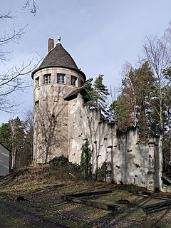
Schlieben is a town in the Elbe-Elster district, in southwestern Brandenburg, Germany. It is situated 22 kilometres (14 mi) north of Bad Liebenwerda. Schlieben was the site of a concentration camp during the Holocaust.

<span class="mw-page-title-main">Sonnewalde</span> Town in Brandenburg, Germany

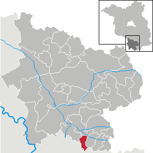
Sonnewalde is a town in the Elbe-Elster district, in Lower Lusatia, Brandenburg, Germany. It is situated 8 km northwest of Finsterwalde.

<span class="mw-page-title-main">Crinitz</span> Municipality in Brandenburg, Germany

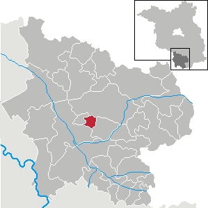
Crinitz is a municipality in the Elbe-Elster district, in Lower Lusatia, Brandenburg, Germany.

<span class="mw-page-title-main">Großthiemig</span> Municipality in Brandenburg, Germany

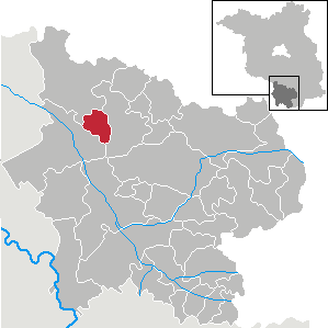
Großthiemig is a municipality in the Elbe-Elster district, in Brandenburg, Germany.

<span class="mw-page-title-main">Heideland, Brandenburg</span> Municipality in Brandenburg, Germany

Heideland is a municipality in the Elbe-Elster district, in Lower Lusatia, Brandenburg, Germany.

<span class="mw-page-title-main">Hirschfeld, Brandenburg</span> Municipality in Brandenburg, Germany

Hirschfeld is a municipality in the Elbe-Elster district, in Brandenburg, Germany.

<span class="mw-page-title-main">Hohenbucko</span> Municipality in Brandenburg, Germany

Hohenbucko is a municipality in the Elbe-Elster district, in Brandenburg, Germany.

<span class="mw-page-title-main">Hohenleipisch</span> Municipality in Brandenburg, Germany

Hohenleipisch is a municipality in the Elbe-Elster district, in Brandenburg, Germany.

<span class="mw-page-title-main">Kremitzaue</span> Municipality in Brandenburg, Germany

Kremitzaue is a municipality in the Elbe-Elster district, in Brandenburg, Germany.

<span class="mw-page-title-main">Lebusa</span> Municipality in Brandenburg, Germany

Lebusa is a municipality in the Elbe-Elster district, in Brandenburg, Germany.

<span class="mw-page-title-main">Lichterfeld-Schacksdorf</span> Municipality in Brandenburg, Germany

Lichterfeld-Schacksdorf is a municipality in the Elbe-Elster district, in Lower Lusatia, Brandenburg, Germany.

<span class="mw-page-title-main">Massen-Niederlausitz</span> Municipality in Brandenburg, Germany

Massen-Niederlausitz is a municipality in the Elbe-Elster district, in Lower Lusatia, Brandenburg, Germany.

<span class="mw-page-title-main">Merzdorf</span> Municipality in Brandenburg, Germany

Merzdorf is a municipality in the Elbe-Elster district, in Brandenburg, Germany.

<span class="mw-page-title-main">Rückersdorf, Brandenburg</span> Municipality in Brandenburg, Germany

Rückersdorf is a municipality in the Elbe-Elster district, in Lower Lusatia, Brandenburg, Germany.

<span class="mw-page-title-main">Sallgast</span> Municipality in Brandenburg, Germany

Sallgast is a municipality in the Elbe-Elster district, in Lower Lusatia, Brandenburg, Germany.

<span class="mw-page-title-main">Schönborn, Brandenburg</span> Municipality in Brandenburg, Germany

Schönborn is a municipality in the Elbe-Elster district, in Lower Lusatia, Brandenburg, Germany.

<span class="mw-page-title-main">Schraden</span> Municipality in Brandenburg, Germany

Schraden is a municipality in the Elbe-Elster district, in Brandenburg, Germany.

<span class="mw-page-title-main">Tröbitz</span> Municipality in Brandenburg, Germany

Tröbitz is a municipality in the Elbe-Elster district, in Lower Lusatia, Brandenburg, Germany.

References

  1. Landkreis Elbe-Elster Wahl der Bürgermeisterin / des Bürgermeisters, accessed 1 July 2021.
  2. "Bevölkerung im Land Brandenburg nach amtsfreien Gemeinden, Ämtern und Gemeinden 31. Dezember 2020". Amt für Statistik Berlin-Brandenburg (in German). June 2021.
  3. Reese, William J. (2002). Power and the promise of school reform: grassroots movements during the progressive era. Teacher's College Press. p. 220. ISBN   978-0-8077-4227-3.
  4. Detailed data sources are to be found in the Wikimedia Commons.Population Projection Brandenburg at Wikimedia Commons