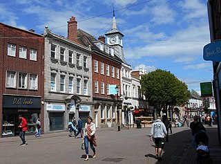
Nuneaton is a market town in Warwickshire, England, close to the county border with Leicestershire to the north-east. Nuneaton's population at the 2021 census was 88,813, making it the largest town in Warwickshire. Nuneaton's urban area, which also includes the large villages of Bulkington and Hartshill, had a population of 99,372 at the 2021 census.

Southam is a market town and civil parish in the Stratford-on-Avon district of Warwickshire, England, located about 6+1⁄2 miles (10 km) east-southeast of Leamington Spa. In the 2021 census, the population of Southam was 8,114.

Bedworth is a market town in the borough of Nuneaton and Bedworth, Warwickshire, England. It is situated between Coventry, 6 miles to the south, and Nuneaton, 3 miles (5 km) to the north.

Hinckley is a market town in south-west Leicestershire, England. It is administered by Hinckley and Bosworth Borough Council. Hinckley is the third largest settlement in Leicestershire, after Leicester and Loughborough. Hinckley is about halfway between Leicester and Coventry and borders Nuneaton in Warwickshire. Watling Street forms part of the Leicestershire/Warwickshire border. The town forms an urban area with the village of Burbage, directly to the south.

Warwickshire is a ceremonial county in the West Midlands of England. It is bordered by Staffordshire and Leicestershire to the north, Northamptonshire to the east, Oxfordshire and Gloucestershire to the south, and Worcestershire and the West Midlands county to the west. The largest settlement is Nuneaton and the county town is Warwick.

Bulkington is a large village and former civil parish near Bedworth, in the Nuneaton and Bedworth district of Warwickshire, England. In the 2011 census the ward had a population of 6,146 decreasing slightly to 6,080 at the 2021 census. It is located around 6 miles (10 km) northeast of Coventry, just south of the town of Nuneaton, east of Bedworth and 5 miles (8 km) southwest of Hinckley. Despite historically having stronger links with Bedworth, Bulkington forms part of the Nuneaton Urban Area. Bulkington was mentioned in the Domesday Book as Bochintone, meaning "estate associated with a man called Bulca".

Meriden is a village and civil parish in the Metropolitan Borough of Solihull, West Midlands, England. Historically, it is part of Warwickshire and lies between the cities of Birmingham and Coventry. It is located close to the North Warwickshire district border within a green belt of the countryside known as the Meriden Gap and is in the ecclesiastical parish of the Diocese of Coventry.
Coleshill is a market town and civil parish in the North Warwickshire district of Warwickshire, England, taking its name from the River Cole, on which it stands. It had a population of 6,900 in the 2021 Census, and is situated 11 miles (18 km)east of Birmingham, 9 miles (14 km) southeast of Sutton Coldfield, 11 miles (18 km) south of Tamworth, 13 miles (21 km) northwest of Coventry by road and 13 miles (21km) west of Nuneaton. It borders the parish village of Kingshurst in the Metropolitan Borough of Solihull to the west. It is also home to the 502 year The Coleshill School seated next to the dual carriageway.

This is about the history of the County of Warwick situated in the English Midlands. Historically, bounded to the north-west by Staffordshire, by Leicestershire to the north-east, Northamptonshire to the east, Worcestershire to the west, Oxfordshire to the south, Gloucestershire to the south-west, an exclave of Derbyshire to the far north, and less than 400 yards from the border with Shropshire in the far west.

Wolvey is a village and parish in Warwickshire, England. According to the 2011 census it had a population of 1,942, which increased to 2,121 at the 2021 census.
Henley-in-Arden is a market town and civil parish in the Stratford-on-Avon District in Warwickshire, England. The town takes its last name from the former Forest of Arden. Henley is known for its variety of historic buildings, some of which date back to medieval times, and its wide variety of preserved architectural styles. The one-mile-long (1.6 km) High Street is a conservation area.
Ansley is a civil parish in Warwickshire consisting of Ansley, Ansley Common, Church End, Birchley Heath and, previously, Ansley Hall Colliery.

Pailton is a village and civil parish in the Borough of Rugby, Warwickshire, England. Its population in 2001 was recorded as 482, increasing at the 2011 Census to 516, reducing again to 483 in the 2021 Census. The village was originally known as Pailington.

Leamington Hastings is a small village and larger civil parish in Warwickshire, England. The civil parish covers Leamington Hastings itself, plus the nearby hamlets of Broadwell, Hill and Kites Hardwick. Its population in the 2011 census was 440, increasing slightly to 466 at the 2021 census.

Hartshill is a large village and civil parish in North Warwickshire, England, adjoined with the much larger town of Nuneaton, the town centre of which is 2.5 miles (4 km) to the south-east. The parish borders the district of Nuneaton and Bedworth at the south, the North Warwickshire district parishes of Ansley at the south-west, Mancetter at the north-west, and Caldecote at the east, and the parish of Witherley in Leicestershire to the north-east from which it is separated by the A5 road. The market town of Atherstone is 3.5 miles (6 km) to the north-west.

Burton Hastings is a village and civil parish in the English county of Warwickshire.

Old Arley is a village in the civil parish of Arley, in the north of Warwickshire, England, 5.5 miles (8.9 km) west of Nuneaton and 10 miles (16 km) north west of the city of Coventry.
Horeston Grange is a suburban area of Nuneaton, Warwickshire in England.

Grendon is a civil parish which includes both Old Grendon and New Grendon in North Warwickshire, England. Old Grendon is a village situated three miles (5 km) west of Atherstone and five miles (8 km) east of Tamworth centred on the A5. It lies on the north-western tip of Warwickshire, divided from Leicestershire by a small stream and by the River Anker. Also, Grendon has since enlarged and has a population of 1000.
Fillongley Castle was a motte and bailey castle and later a fortified manor house in Fillongley in Warwickshire, England. Today, only earthworks and partial ruins exist.


