Fischbach (Taunus)

Last updated
Fischbach (Taunus)
Blick ueber Fischbach.JPG
Fischbach Wappen.svg
Location of Fischbach (Taunus)
Fischbach (Taunus)
Germany adm location map.svg
Red pog.svg
Fischbach (Taunus)
Hesse location map.svg
Red pog.svg
Fischbach (Taunus)
Coordinates: 50°09′07″N08°25′19″E / 50.15194°N 8.42194°E / 50.15194; 8.42194
Country Germany
State Hesse
Admin. region Darmstadt
District Urban district
Town Kelkheim
Area
  Total6.81 km2 (2.63 sq mi)
Elevation
222 m (728 ft)
Population
  Total6,000
  Density880/km2 (2,300/sq mi)
Time zone UTC+01:00 (CET)
  Summer (DST) UTC+02:00 (CEST)
Postal codes
65779
Dialling codes 06195
Vehicle registration MTK
Trinity Church, 1781 Mk Frankfurt Fischbach Kirche.jpg
Trinity Church, 1781

Fischbach (English: fish brook) is a Stadtteil , one of six administrative subdivisions, of the town of Kelkheim in the Main-Taunus district of Germany. It is situated at the western border of Frankfurt am Main in the Taunus hills. Fischbach is a middle-class town and has about 5,900 inhabitants.

Contents

Geography

Location

Hills surrounding Fischbach Mk Frankfurt Fischbacher Kopf.jpg
Hills surrounding Fischbach

The town lies in the valley of a stream with the same name in the Taunus hills. It is north-west of central Kelheim and adjoins Hornau to the east. The town of Eppstein is to the west and Königstein im Taunus is northeast of Fischbach. The source of the Fischbach stream is in Ruppertshain. It flows through Fischbach and the Fischbachtal (Fishbachl valley) to merge with the Schwarzbach stream in Eppstein. Hill peaks around Fischbach are the Fischbacher Kopf, Staufen and Rossert. Fischbach is a dormitory town for many working in Frankfurt am Main.

Traffic

Bundesstraße 455 (federal highway 455) heads from Königstein via Fischbach to Eppstein and Wiesbaden. The former through road was substituted by a bypass in the early 1980s. The new road does not bypass Fischbach but crosses the town on an artificial embankment, with a bridge over the central street Langstraße. Bus routes connect Fischbach with Kelkheim railway station and the Frankfurt Transit system.

Structure of the town

The old town centre is situated at the intersection of the main roads from Kelkheim to the suburb of Ruppertshain and from Königstein to Eppstein. The first road, Langstraße, is the main road of the old part of the village. In the 19th century Fischbach grew along both streets, especially Kelkheimer Straße and Eppsteiner Straße. Fischbach's population swelled after World War II with refugees from areas that were ceded to other countries, leading to street names such as Egerländer Straße and Königsberger Straße. Residential areas were built on both sides of Kelkheimer Straße and on the south-side of the town, around Staufenstraße and Sodener Straße. In the north, only a small residential estate was built on a former brickyard area (An der Ziegelei). In the 1970s summer cottages were built on the road to Königstein, and are now year-round residences.

History

Administrative history

Fischbach was founded by Franks. The first document which proves the existence of Fischbach (gift to Fulda convent), is dated in the year 780. In the 8th and 9th centuries, imperial laws appear. In 813, the village was in possession of Earl Liutfried as royal feud. Starting from 890 Fischbach was part of the shire of Uualahes and during Early and High Middle Ages a member of the Niddagau province. [1]

In 1348 the Lords of Eppstein became the new rulers. In 1581 Fischbach became part of Archbishopric of Mainz and was governed from Königstein. After Napoleon split the Holy Roman Empire in 1806, Fischbach and the vicinity was part of Duchy of Nassau. Nassau was annexed by Prussia in 1866 degraded to Wiesbaden district of the Prussian province Hessen-Nassau. Fischbach attended to this administration till the foundation of Hesse in 1946.

After being integrated to Prussia, Fischbach belonged to the Upper-Taunus district. Since 1928 it was part of the newly founded Main-Taunus district. In 1977 Fischbach was incorporated to the city of Kelkheim, together with the former community Rossert (Ruppertshain and Eppenhain).

Coat of arms

Fischbach Wappen.svg

The emblem shows the "chevrons of Eppstein" on the right as symbol of the former affiliation to the neighbour town. When Fischbach was part of Archbishopric of Mainz, the chevrons had been substituted by the "wheel of Mainz" (Mainzer Rad). It has been removed after Fischbach became part of Hessen-Nassau. The left field shows, according to the town name, two red fishes in a silver creek.

Economical and social history

Fischbach, 1893 Meyers5 Frankfurt Fischbach.png
Fischbach, 1893

The economy of the village was based on agriculture and fruit-growing for centuries. Typically for the lower Taunus are fruit grasslands with apple trees. Since the beginning of the 19th century, many carpenters and joineries were located in the town. Different from Kelkheim, the furniture industry could not be conserved to the present. Besides, the clayey ground allowed setting up brickyards. Also the industry, especially Farbwerke in Höchst (Hoechst AG, today Industriepark Höchst), is a source of income since the late 19th century. The opening of railway line from Königstein to Höchst in 1901 improved the connections to Höchst and Frankfurt. Before that, many workers had to walk every morning to Soden railway station (approx. 8 km (5.0 mi)).

After World War II, Fischbach had about 1,000 inhabitants. Due to refugee settlement, mainly from Sudetenland, the number of residents was doubled. The village became even bigger in the 1960s and 1970s due to suburbanization. Fischbach changed from a small Taunus-village to a suburb of Frankfurt. The number of residents rose to about 6,000 in the early 1980s and has changed little since then.

Due to strong immigration of citizens from Frankfurt, the confessional (mainly Catholic in former times) and the social structure changed: In addition to the long-established village residents, mostly craftsmen and farmers, an academic affected middle-class appeared (employees of Hoechst AG)

Points of interest

Church Saint Trinity

In 1781, church Saint Trinity substituted an older church which was built in 1686. The building contains some extravaganza of this time and provides an impressive view from the lower meadows nearby. The church contains the so-called “Roteltisstein”, a Christian tombstone from the 7th century. It was transferred to Fischbach in 1868 from a demolished pilgrim chapel nearby (Gimbach). The stone proves the early Christianisation in this region.

Church Saint John

Like everywhere in the former area of Archbishopric of Mainz, inhabitants of Fischbach were traditionally catholic. The result of the large number of Protestants immigrated after World War II, was a growing demand for a Protestant church. A community was founded in the 1960s and is named after John the Baptist. The church has a modern style and has big, coloured windows.

Rettershof

Hofgut Retters. Mk Frankfurt Fischbach Retters.jpg
Hofgut Retters.

Rettershof, northeast of Fischbach, was founded in 1186 as a premonstratensian convent. During the protestant reformation, the landlord closed the convent in 1559 and converted it to a farm. The church of the convent was destroyed during the Thirty Years war. In 1884 an Englishman bought the manor and built a new mansion in Tudor style. His successors built a restaurant in 1938, which offered products from the farm. The city of Kelkheim bought Rettershof in 1980 and renovated it. Today, Rettershof consists of three parts: the historically styled yard of the manor, the former mansion and the restaurant. For some years in the 1908s the manor was the European headquarters of International Society for Krishna Consciousness. It is now a luxury hotel.

Gimbacher Hof

Though Hofgut Gimbach can only reached by car via Kelkheim, it belongs to Fischbach. The way from Fischbach to Gimbacher Hof is only for pedestrians and bikes. The way leads through land under environmental conservation.

Until 1868, Gimbach was the location of a pilgrim chapel. After its demolition the altar was transferred to Saint Trinity in Fischbach, but the Gimbach pilgrimage continues to this day.

Gimbacher Hof's name comes from the Gimbach, a stream that starts nearby when three tributaries join. The earliest known document of its existence dates to 1287, recorded as the "Gynnenbach". [2]

The manor grounds are used for horse breeding, for growing and pressing Apfelwein, the local cider, and as for camping.

Hanseklingerbrunnen

The bronze fountain in the village center was created in 1987 by Johannes Norbert Klarmann. It depicts a craftsman drinking water from the fountain.

Public facilities

Former town hall, today community center.

Bürgerhaus

The town hall of Fischbach was established shortly before the village was incorporated to Kelkheim. Today the building is community center, contains outposts of Kelkheim town authorities and is home for several clubs. The functional architecture is typical for buildings of the 1970s. Fire brigade facilities are also located at the town hall square.

Albert-von-Reinach school

Albert-von Reinach-school is an elementary school. It is located above the town hall square and consists of two buildings. The catchments area is equivalent to Fischbach area. The school is named after Albert von Reinach (* November 7, 1842 in Frankfurt am Main; † January 12, 1905). He was a banker from Frankfurt, who built a villa nearby the village. Albert von Reinach supported the school with noble donations. The older building was erected in 1952/54, the newer one in 1967. The complex replaced the old school building near St. Trinity church, which was placed there at least since 1822 and demolished in 1967. The first school in Fischbach was documented in 1604.

Staufen school / Eichendorff school / Gesamtschule Fischbach

The Staufenschule was a school for children from Fischbach, Hornau, Ruppertshain and Eppenhain. It was absorbed into the Eichendorff school on 31 July 2006. Due to rising student numbers the Eichendorff school's homonymous sister located in Kelkheim-Mitte has separated from Fischbach's school. It has been renamed to Gesamtschule Fischbach (General school of Fischbach, GSF) and put under its own administration in 2018.

Staufenhalle

After a long planning period, a new sports hall opened in 2002. The “Staufenhalle” replaced an old version from 1971. The hall is the largest roofed room in Kelkheim. It has a small stand and is used by schools and sports clubs.

Sports field

Open air sports events take place on Fischbach sports field. It is beside woods in the west end of the village. It is mainly used for football matches of the local football club SV Fischbach and was opened on 31 May 1930. In 1952 the area was modified. The ground was rotated by 90 degrees and changing rooms were built. The sports field reopened on 2 August 1953. In 1982 the facilities were renovated and a house for club activities was built. The sports field was equipped with an artificial turf during summer 2008.

Events

Fischbach celebrates carnival every year in February or March, with a Carnival Monday parade attracting approximately 25,000 visitors.

Kermesse (Kerb) is celebrated each autumn on town hall square. during this time.

The Protestant church community celebrates Saint John's day (June 24).

The Hanseklinger festival in late summer is celebrated in the village center around the homonymous fountain.

Related Research Articles

Main-Taunus is a Kreis (district) in the middle of Hessen, Germany and is part of the Frankfurt/Rhine-Main Metropolitan Region as well as the Frankfurt urban area. Neighboring districts are Hochtaunuskreis, district-free Frankfurt, Groß-Gerau, district-free Wiesbaden, Rheingau-Taunus. It is the second most densely populated rural district in Germany.

<span class="mw-page-title-main">Hofheim, Hesse</span> Town in Hesse, Germany

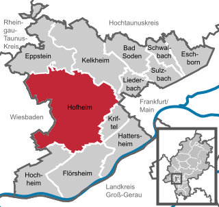
Hofheim is the administrative centre of Main-Taunus-Kreis district, in the south of the German state of Hesse. Its population in September 2020 was 39,946.

<span class="mw-page-title-main">Kronberg im Taunus</span> Town in Hesse, Germany

Kronberg im Taunus is a town in the Hochtaunuskreis district, Hesse, Germany and part of the Frankfurt Rhein-Main urban area. Before 1866, it was in the Duchy of Nassau; in that year the whole Duchy was absorbed into Prussia. Kronberg lies at the foot of the Taunus, flanked in the north and southwest by forests. A mineral water spring also rises in the town.

<span class="mw-page-title-main">Eppstein</span> Town in Hesse, Germany

Eppstein is a town in the Main-Taunus-Kreis, in Hesse, Germany. Eppstein lies west of Frankfurt am Main, around 12 km north east of the state capital Wiesbaden, and is at the edge of the Taunus mountains. The ruins of the Eppstein castle is a prominent landmark, and houses a museum.

<span class="mw-page-title-main">Zeilsheim</span> Quarter of Frankfurt am Main in Hesse, Germany

Zeilsheim is a quarter of Frankfurt am Main, Germany. It is part of the Ortsbezirk West and is subdivided into the Stadtbezirke Zeilsheim-Ost, Zeilsheim-Süd and Zeilsheim-Nord.

<span class="mw-page-title-main">Königstein im Taunus</span> Town in Hesse, Germany

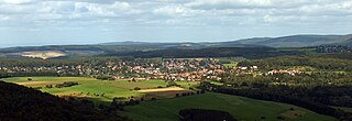
Königstein im Taunus is a health spa and lies on the thickly wooded slopes of the Taunus in Hesse, Germany. The town is part of the Frankfurt Rhein-Main urban area. Owing to its advantageous location for both scenery and transport on the edge of the Frankfurt Rhine Main Region, Königstein is a favourite residential town. Neighbouring places are Kronberg im Taunus, Glashütten, Schwalbach am Taunus, Bad Soden am Taunus and Kelkheim.

<span class="mw-page-title-main">Niedernhausen</span> Municipality in Hesse, Germany

Niedernhausen im Taunus is a municipality in the Rheingau-Taunus-Kreis in the Regierungsbezirk of Darmstadt in Hesse, Germany, with almost 15,000 inhabitants.

<span class="mw-page-title-main">Kelkheim</span> Town in Hesse, Germany

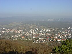
Kelkheim, officially "Kelkheim (Taunus)", is a town in the Main-Taunus district in Hesse, Germany, close to Germany's financial center Frankfurt/Main.

<span class="mw-page-title-main">Schwalbach am Taunus</span> Town in Hesse, Germany

Schwalbach am Taunus, a town in the Main-Taunus-Kreis district, in Hesse, Germany, population about 14,000, is a dormitory town to Frankfurt, situated some 11 km east of Schwalbach. There is evidence of human habitation dating back to Neolithic times, and recorded history going back to 781 AD. Until the end of the Second World War, it was a farming village, but in the post-war era it expanded rapidly and became economically linked to Frankfurt. Schwalbach was granted Gemeinde (municipal) status in 1970.

<span class="mw-page-title-main">Bad Camberg</span> Town in Hesse, Germany

Bad Camberg is, with 14,500 inhabitants, the second largest town in Limburg-Weilburg district in Hesse, Germany, as well as the southernmost town in the Regierungsbezirk of Gießen. It is located in the eastern Taunus in the Goldener Grund some 30 km north of Wiesbaden, 18 km southeast of Limburg an der Lahn, and 44 km northwest of Frankfurt, as well as on the German Timber-Frame Road. Bad Camberg is the central community of the Goldener Grund with good infrastructure, and a lower centre partly with a middle centre's function.

<span class="mw-page-title-main">Steinbach (Taunus)</span> Town in Hesse, Germany

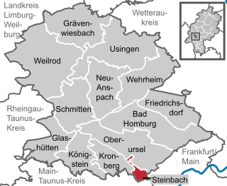
Steinbach is a town in the Hochtaunuskreis that borders Frankfurt am Main to the east. Other neighbouring towns are Oberursel, Kronberg im Taunus and Eschborn. It is in the German state of Hesse.

<span class="mw-page-title-main">Glashütten (Taunus)</span> Municipality in Hesse, Germany

Glashütten is a small municipality in the Hochtaunuskreis. This community in the Taunus, which is made up of the three formerly independent communities of Glashütten, Schloßborn and Oberems, lies in the Hochtaunus Nature Park, not far from Königstein im Taunus, Germany.

<span class="mw-page-title-main">Wheel of Mainz</span> Coat of arms of Mainz

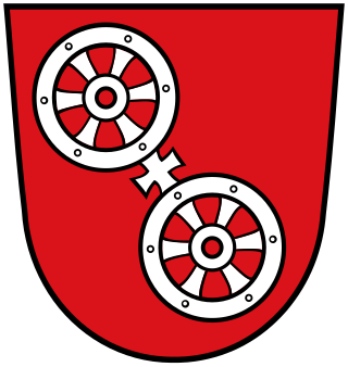
The Wheel of Mainz or Mainzer Rad, in German, was the coat of arms of the Archbishopric of Mainz and thus also of the Electorate of Mainz (Kurmainz), in Rhineland-Palatinate, Germany. It consists of a silver wheel with six spokes on a red background. The wheel can also be found in stonemasons' carvings and similar objects. Currently, the City of Mainz uses a double wheel connected by a silver cross.

<span class="mw-page-title-main">Taunus Railway</span> Electrified railway in central western Germany

The Taunus Railway is a double-track electrified railway line, which connects Frankfurt and Wiesbaden, Germany. It is 41.2 km long and follows the course of the Main on its north side, running quite close to it in some places. Its first stage was opened in September 1839 and is thus the oldest railway line in the German state of Hesse and one of the oldest in Germany. Today it is used by Regional-Express trains between Frankfurt and Wiesbaden and the trains of line S1 of the Rhine-Main S-Bahn between Frankfurt-Höchst and Wiesbaden. Between Frankfurt Hbf and Frankfurt-Höchst, they run on the line of the former Hessian Ludwig Railway.

<span class="mw-page-title-main">Bundesstraße 455</span> Federal highway in Germany

Bundesstraße 455 is a German Bundesstraße in the federal state of Hesse. The route runs southwest from Schotten in Vogelsbergkreis to Mainz-Kastel, a borough of the Hessian capital city of Wiesbaden.

<span class="mw-page-title-main">Frankfurt-Höchst station</span>

The Frankfurt-Höchst station is an important station in the Frankfurt district of Höchst and is the second largest station in the city with twelve tracks. It is currently mainly used by S-Bahn, suburban and regional services. It is the most important public transport node in western Frankfurt.

<span class="mw-page-title-main">Schloßborn</span> Ortsteil of Glashütten in Hesse, Germany

Schloßborn (Schlossborn) is a village in the municipality of Glashütten, Hesse, Germany. It is located northeast of Wiesbaden and northwest of Frankfurt in the hilly Taunus region.

<span class="mw-page-title-main">Königstein Railway</span>

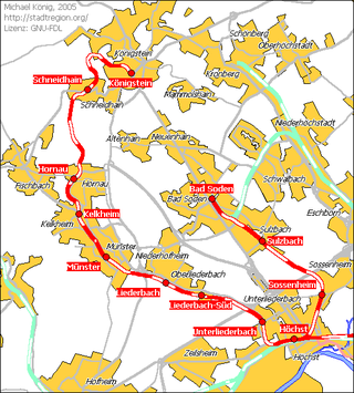
The Königstein Railway is a 1902 opened, single-track and non-electrified secondary railway line that connects the town of Königstein im Taunus with the city of Frankfurt am Main on the southern edge of the Taunus in the German state of Hesse.

<span class="mw-page-title-main">Kelkheim station</span>

Kelkheim station is the most important station on the Königstein Railway from Höchst to Königstein on the western edge of Frankfurt am Main in the German state of Hesse. It is the location of the scheduled train crossings on the single track line. It is the middle one of three stations in the town of Kelkheim and serves the districts of Kelkheim-Mitte and Fischbach.

<span class="mw-page-title-main">Rettershof</span> Rettershof is a crown domain of Fischbach

Rettershof is a crown domain northeast of Fischbach, a district of Kelkheim in the Vordertaunus. It goes back to a former Premonstratensian monastery. From the 12th century until 1559, nuns were resident at Retters, and later various owners used the estate and its lands as a farmstead. Today, in addition to its continued agricultural use, Rettershof is a popular regional excursion destination.

References

  1. "Historisches Ortslexikon : Erweiterte Suche : LAGIS Hessen".
  2. "Kelkheim am Taunus - Kelkheim-Mitte". Archived from the original on 2011-07-19. Retrieved 2011-01-21.