
Hiawatha National Forest is a 894,836-acre (362,127 ha) National Forest in the Upper Peninsula of the state of Michigan in the United States. Commercial logging is conducted in some areas. The United States Forest Service administers this National Forest; it is physically divided into two subunits, commonly called the Eastside 46°14′N84°50′W and Westside 46°08′N86°40′W.

The Boundary Waters Canoe Area Wilderness is a 1,090,000-acre (4,400 km2) wilderness area within the Superior National Forest in northeastern part of the US state of Minnesota under the administration of the U.S. Forest Service. A mixture of forests, glacial lakes, and streams, the BWCAW's preservation as a primitive wilderness began in the 1900s and culminated in the Boundary Waters Canoe Area Wilderness Act of 1978. It is a popular destination for canoeing, hiking, and fishing, and is one of the most visited wildernesses in the United States.

The Chequamegon–Nicolet National Forest is a 1,530,647-acre (6,194.31 km2) U.S. National Forest in northern Wisconsin in the United States. Due to logging in the early part of the 20th century, very little old growth forest remains. Some of the trees that grow there today were planted by the Civilian Conservation Corps in the 1930s. The national forest lands contain trees and vegetation corresponding to the North Woods Ecoregion that is prevalent throughout the upper Great Lakes region.

The Monongahela National Forest is a national forest located in the Allegheny Mountains of eastern West Virginia, USA. It protects over 921,000 acres of federally managed land within a 1,700,000 acres proclamation boundary that includes much of the Potomac Highlands Region and portions of 10 counties.
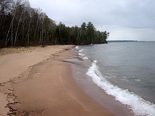
The Apostle Islands National Lakeshore is a U.S. national lakeshore consisting of 21 islands and shoreline encompassing 69,372 acres (28,074 ha) on the northern tip of Wisconsin on the shore of Lake Superior. It is known for its collection of historic lighthouses, sandstone sea caves, a few old-growth remnant forests, and natural animal habitats. It is featured on the America the Beautiful Quarters series.
The protected areas of Michigan come in an array of different types and levels of protection. Michigan has five units of the National Park Service system. There are 14 federal wilderness areas; the majority of these are also tribal-designated wildernesses. It has one of the largest state forest systems as well having four national forests. The state maintains a large state park system and there are also regional parks, and county, township and city parks. Still other parks on land and in the Great Lakes are maintained by other governmental bodies. Private protected areas also exist in the state, mainly lands owned by land conservancies.

The Porcupine Mountains, or Porkies, are a group of small mountains spanning the northwestern Upper Peninsula of Michigan in Ontonagon and Gogebic counties, near the shore of Lake Superior. The Porcupine Mountains were named by the native Ojibwa people, supposedly because their silhouette had the shape of a crouching porcupine. They are home to the most extensive stand of old growth northern hardwood forest in North America west of the Adirondack Mountains, spanning at least 31,000 acres (13,000 ha). The area is popular among tourists, especially Lake of the Clouds in the heart of the mountains, and is part of Porcupine Mountains Wilderness State Park.

Lake Vermilion is a shallow freshwater lake in northeastern Minnesota, United States. The Ojibwe originally called the lake Nee-Man-Nee, which means “the evening sun tinting the water a reddish color”. French fur traders translated this to the Latin word Vermilion, which is a red pigment. Lake Vermilion is located between the towns of Tower on the east and Cook on the west, in the heart of Minnesota's Arrowhead Region at Vermilion Iron Range. The area was mined from the late 19th century until the 1960s, and the Soudan Mine operated just south of the lake.

Gates of the Arctic Wilderness is a wilderness area in the U.S. state of Alaska. Located in the Gates of the Arctic National Park and Preserve, it is 7,245,600-acre (2,932,200 ha) in area, the third-largest designated wilderness area in the United States.

The Seney National Wildlife Refuge is a managed wetland in Schoolcraft County in the U.S. state of Michigan. It has an area of 95,212 acres (385 km2). It is bordered by M-28 and M-77. The nearest town of any size is Seney, Michigan. The refuge contains the Seney Wilderness Area and the Strangmoor Bog National Natural Landmark within its boundaries.

The Ottawa National Forest is a national forest that covers 993,010 acres (401,860 ha) in the Upper Peninsula of the U.S. state of Michigan. It includes much of Gogebic and Ontonagon counties, as well as slices of Iron, Houghton, Baraga, and Marquette counties. The forest is under the jurisdiction of the U.S. Forest Service.

Clark Lake is a lake located in Gogebic County in the U.S. state of Michigan. Clark Lake is one of about two dozen clear, clean lakes located in the Sylvania Wilderness of Ottawa National Forest a few miles to the west of the town of Watersmeet. The shoreline is undeveloped except for a picnic area and boat launch at the northern end. The lake possesses several islands and numerous bays and coves. Large boulders strewn about the shoreline and lake bed add to the scenic beauty of this lake. It is not uncommon to see nesting loons and eagles around the lake's islands, and black bear and wolves inhabit the old-growth forest around the lake. The total surface area of the lake is 820 acres (3.3 km2), with maximum depths of 74 ft (23 m).

Loon Lake is a lake located in Gogebic County in the U.S. state of Michigan. Loon Lake is one of about two dozen clear, clean lakes located in a special wilderness area known as the Sylvania Wilderness, which in turn is located within the Ottawa National Forest a few miles to the west of the town of Watersmeet. The shoreline is completely undeveloped, and surrounded by virgin timber consisting mainly of hemlock and pine. This remote, spring-fed lake is noted for its rugged beauty. The total surface area of the lake is 375 acres (1.5 km2), with maximum depths of 53 feet (16 m).

Deer Island Lake is a lake located in Gogebic County in the U.S. state of Michigan. The Lake is one of about 24 clear, clean lakes located in a special wilderness area known as the Sylvania Wilderness, which in turn is located within the Ottawa National Forest a few miles to the west of the town of Watersmeet. The shoreline is completely undeveloped, and surrounded by virgin forest consisting mainly of hemlock and pine. This crystal-clear spring-fed lake is one of the most remote in the Sylvania Tract, but is well worth the journey for those intrepid enough to make it. The total surface area of the lake is 346 acres (1.4 km2), with maximum depths of 55 ft. The lake is named for the very large island in the center of the lake, which deer inhabit by crossing back and forth on the ice in winter. Several smaller islands and numerous rocky shoals add to the overall beauty of this fine body of water.
Sylvania Wilderness is an 18,327 acres (7,417 ha) protected area located a few miles west of Watersmeet Township, Michigan. Sylvania is located entirely within the bounds of the Ottawa National Forest, and is currently being managed as a wilderness area as part of the National Wilderness Preservation System by the U.S. Forest Service.

The Siskiyou Wilderness is a federal wilderness area designated by the passage of the California Wilderness Act of 1984. Originally, the land area was 153,000 acres (620 km2) The Northern California Wild Heritage Act of 2006 added 30,122 acres (121.90 km2) for the current total of 182,802 acres (739.77 km2). All of the wilderness is in Northern California and is managed by the U.S. Forest Service. The wilderness spans three national forests: the Rogue River–Siskiyou, the Klamath, and the Six Rivers.
The Tamarac Wilderness is a 2,180-acre (9 km2) wilderness area in the U.S. state of Minnesota. Established by the United States Congress in 1976, Tamarac Wilderness is composed primarily of small lakes, wooded potholes, bogs and marshes. The wilderness consists of four sections of the 42,724-acre (173 km2) Tamarac National Wildlife Refuge: three islands in Tamarac Lake totaling about 65 acres (0 km2) in the southwest section, and more than 2,180 acres (9 km2) in the northwest corner.
Green Bay National Wildlife Refuge is a National Wildlife Refuge of the United States located in the state of Wisconsin. It includes five all or part of six islands in Lake Michigan: Hog Island, Plum Island, Pilot Island, part of St. Martin Island and Rocky Island. Additionally it includes part of Detroit Island. The islands are near Washington Island off the tip of the Door Peninsula of Wisconsin and the Garden Peninsula of Michigan.
The Peters Mountain Wilderness is an area protected by act of Congress to maintain its present, natural condition. As part of the wilderness system. it helps to preserve a variety of natural life forms and contributes to a diversity of plant and animal gene pools. Over half of the ecosystems in the United States exist within designated wilderness.
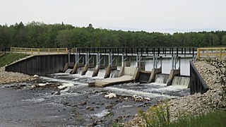
The Reedsburg Dam is a non-hydroelectric barrage dam crossing the Muskegon River in eastern Missaukee County in the U.S. state of Michigan. Located in rural Enterprise Township, the dam was constructed in 1940 by the Civilian Conservation Corps to alleviate flooding from Houghton Lake, which is the source of the Muskegon River approximately 6 miles (9.7 km) upstream.

