
SeaTac is a city in southern King County, Washington, United States. The city is an inner-ring suburb of Seattle and part of the Seattle metropolitan area. The name "SeaTac" is derived from the Seattle–Tacoma International Airport, itself a portmanteau of Seattle and Tacoma.

Glen Carbon is a village in Madison County, Illinois, United States, 14 miles (23 km) northeast of St. Louis. The population was 13,842 at the 2020 census.
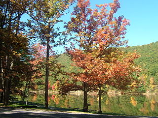
Tobyhanna Township is a township in Monroe County, Pennsylvania, United States. The population was 8,290 at the 2020 census. Tobyhanna Township has Tobyhanna Elementary Center and Locust Lake Village.

Federal Way is a city in King County, Washington, United States and part of the Seattle metropolitan area. One of the most recently incorporated cities in the county, its population was 101,030 at the 2020 census. Federal Way is the 10th most populous city in Washington and the 5th most populous in King County.

Kenmore is a city in King County, Washington, United States, along the northernmost shore of Lake Washington. It is a suburban commuter town at the mouth of the Sammamish River, 12 miles (19 km) northeast of downtown Seattle and 2 miles (3.2 km) west of Bothell. The population was 20,460 at the 2010 census. Kenmore Air Harbor is the largest seaplane-only passenger facility of its kind in the United States.

St. Peters is a city in St. Charles County, Missouri, United States. The population was 57,732 at the 2020 census, making it the eleventh-largest city in Missouri. It is a northwestern suburb of St. Louis.

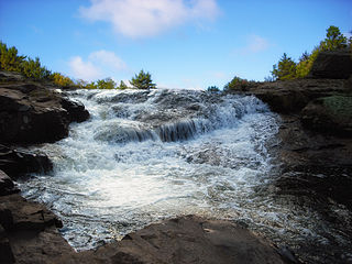
The North Country Trail is a long-distance hiking trail in the midwestern and northeastern United States. The trail extends roughly 4,800 miles (7,700 km) from Lake Sakakawea State Park in North Dakota to the Appalachian Trail in Green Mountain National Forest in Vermont, passing through eight states along its route. As of 2023, most of the trail is in place, though about one-third of the distance consists of road walking; those segments are frequently evaluated for transfer to off-road segments on nearby public or private lands.
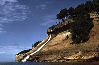
Pictured Rocks National Lakeshore is a U.S. National Lakeshore in the Upper Peninsula of Michigan, United States. It extends for 42 mi (68 km) along the shore of Lake Superior and covers 73,236 acres. The park has extensive views of the hilly shoreline between Munising and Grand Marais in Alger County, with picturesque rock formations, waterfalls, and sand dunes.
The Tamiami Trail is the southernmost 284 miles (457 km) of U.S. Highway 41 (US 41) from State Road 60 (SR 60) in Tampa to US 1 in Miami. A portion of the road also has the hidden designation of State Road 90 (SR 90).
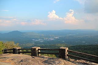
Black Rock Mountain State Park is a 1,743-acre (705 ha) Georgia, United States, state park west of Mountain City in Rabun County, in the Blue Ridge Mountains. It is named after its sheer cliffs of dark-colored biotite gneiss. Astride the Eastern Continental Divide at an elevation of 3,640 feet (1,110 m), the park provides many scenic overlooks and 80-mile (130 km) vistas of the southern Appalachian Mountains. On a clear day, four states are visible: Georgia, North Carolina, South Carolina, and Tennessee. In addition to Black Rock Mountain itself, the park includes four other peaks over 3,000 feet (910 m) in elevation, making it the state's highest state park. As of 2019, it was open to visitors year round.

Seneca Creek State Park is a public recreation area encompassing more than 6,300 acres (2,500 ha) along 14 miles of Seneca Creek in its run to the Potomac River in Montgomery County, Maryland. The park features facilities for boating and fishing as well as trails for hiking, cycling, and horseback riding. It is managed by the Maryland Department of Natural Resources.

Ohiopyle State Park is a Pennsylvania state park on 20,500 acres (8,300 ha) in Dunbar, Henry Clay and Stewart Townships, Fayette County, Pennsylvania in the United States. The focal point of the park is the more than 14 miles (23 km) of the Youghiogheny River gorge that passes through the park. The river provides some of the best whitewater boating in the Eastern United States. Ohiopyle State Park is bisected by Pennsylvania Route 381 south of the Pennsylvania Turnpike. The park opened to the public in 1965 but was not officially dedicated until 1971.
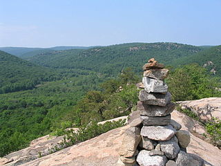
Popolopen is the name of several related landmarks mainly within the Hudson Highlands of Orange County, New York. These include a mountain, Popolopen Torne—or simply "The Torne", and a short and steep-sided nearby valley officially called Hell Hole, but often Popolopen Gorge. Popolopen Creek runs through this valley. The Popolopen Bridge spans its mouth at the Hudson River and is crossed by Route 9W. Popolopen Lake feeds the headwaters of its namesake creek. Despite local usage, the United States Board on Geographical Names recognizes only the lake, creek and bridge as bearing the name "Popolopen."
Brockway Mountain Drive is an 8.8-mile-long (14.2 km) scenic roadway just west of Copper Harbor in the Upper Peninsula of Michigan in the United States. Drivers can access the road from State Highway M-26 on either end near Eagle Harbor to the west or Copper Harbor to the east in the Keweenaw Peninsula. The drive runs along the ridge of Brockway Mountain on the Keweenaw Fault and climbs to 1,320 feet (402 m) above sea level, 720 feet (219 m) above the surface of Lake Superior. Several viewpoints along the route allow for panoramas of Copper Harbor, Lake Superior, and undeveloped woodland. On a clear day, Isle Royale is visible approximately 50 miles (80 km) in distance from the top of the mountain.
Poe Valley State Park is a 620-acre (251 ha) Pennsylvania state park in Penn Township, Centre County, Pennsylvania in the United States. The park is surrounded by Bald Eagle State Forest. Poe Paddy State Park is 4 miles (6.4 km) to the east. The forests of the park surround the 25-acre (10 ha) Poe Lake. Poe Valley State Park is in isolated Poe Valley which lies between Potters Mills on U.S. Route 322 and Millheim on Pennsylvania Route 45. The park was closed during the 2008 and 2009 season while the lake was drained for dam repairs and the park facilities were upgraded.
Fort Dupont Park is a 376-acre (1.52 km2) wooded park under the management of the National Park Service located in Washington, DC. The name of the park comes from the old Civil War earthwork fort that lies within the park. The fort was one of several designed to defend Washington from a Confederate attack during the Civil War. There are few remains of the actual fortifications.
Fort Parker State Park is a Texas state park near Mexia and to Limestone County seat Groesbeck, Texas. The city of Mexia and three local landowners donated the land creating the park in 1935. From 1935 to 1942, Civilian Conservation Corps Company 3807(C) built roads, recreational facilities, the concession building and a 423-foot (129 m) dam of limestone, concrete, and soil across the Navasota River, creating Lake Fort Parker. The park was dedicated by former Texas Governor Pat Neff and opened to the public in May 1941.

Lake Bob Sandlin State Park is a state park in Titus County, Texas managed by the Texas Parks and Wildlife Department. The park covers 639.8 acres of land on the northern shore Lake Bob Sandlin about 10 miles southwest of Mount Pleasant.

Penn State Forest is a 3,366-acre (5.259 sq mi) state park in Burlington County, New Jersey, United States. The forest is protected as a section of the environmentally sensitive Pine Barrens. Various recreational resources are available to visitors including Oswego Lake and the Oswego River for boating and fishing. The lake has a picnic area with a boat launch and primitive restrooms. Miles of unpaved roads composed of gravel, dirt, and sand traverse all areas of the forest. The roads are open for hiking, mountain biking, horseback riding, and cross-country skiing, as well as four-wheel driving. Hunting for deer, wild turkey, water fowl, and small game is permitted in season. A section of the Pine Barren Plains, a globally rare dwarf forest ecosystem that reaches a mature canopy height of about 4 ft (1.2 m), is located in the northeastern portion of the park. Penn State Forest is operated and maintained by the New Jersey Division of Parks and Forestry.
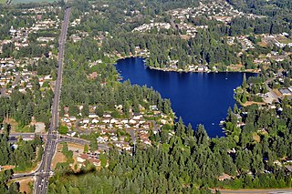
Star Lake is located in southern King County, Washington in the Lakeland North census-designated place. Interstate 5 runs just to the west of the lake.


