 | |
| Proportion | 3:5 |
|---|---|
| Adopted | 29 October 2014 |
| Designed by | Jenny Stevens |
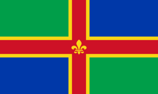
The Exmoor flag is the flag of the moorland area of Exmoor, in west Somerset and north Devon. It was registered with the Flag Institute as a regional flag on 29 October 2014.
| | |
| Proportion | 3:5 |
|---|---|
| Adopted | 29 October 2014 |
| Designed by | Jenny Stevens |
The Exmoor flag is the flag of the moorland area of Exmoor, in west Somerset and north Devon. It was registered with the Flag Institute as a regional flag on 29 October 2014.
The stag's head stands for the moorland's iconic wildlife, particularly its red deer. The star symbolises Exmoor National Park's status as Europe's first designated International Dark Sky Reserve, awarded in 2011. [1] The dark blue field is for both the sky and sea. The wavy lines of white, purple and green represent Exmoor as a place where the sea meets cliffs, moorland and forests, as well as the region's many footpaths. [2] [3]
The Pantone colours for the flag are:
In 2014, it was announced that a competition to create an official flag for Exmoor would be held, to coincide with the 60th anniversary of the establishment of the Exmoor National Park in 1954. The competition was launched on 16 June 2014, and ran until 21 July. [4] [5] In total, 261 designs were submitted for the competition, with some entries coming from as far afield as Australia and the United States. [2]
A panel of eight judges reviewed the proposals before ultimately selecting a shortlist of five (in a divergence from the original plan to end the competition with four finalists), [6] which were put to a public vote on 20 August 2014, with voting remaining open until 10 September. [7] 858 votes were cast in total. [2]
The winning design was unveiled on 29 October, at a ceremony at Minehead railway station. The designer was London resident Jenny Stevens. [8]

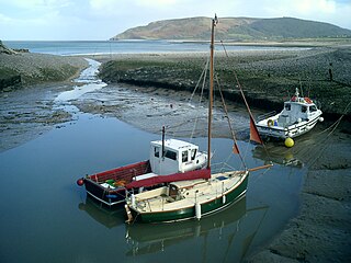
Exmoor is loosely defined as an area of hilly open moorland in west Somerset and north Devon in South West England. It is named after the River Exe, the source of which is situated in the centre of the area, two miles north-west of Simonsbath. Exmoor is more precisely defined as the area of the former ancient royal hunting forest, also called Exmoor, which was officially surveyed 1815–1818 as 18,810 acres (7,610 ha) in extent. The moor has given its name to a National Park, which includes the Brendon Hills, the East Lyn Valley, the Vale of Porlock and 55 km (34 mi) of the Bristol Channel coast. The total area of the Exmoor National Park is 692.8 km2 (267.5 sq mi), of which 71% is in Somerset and 29% in Devon.

Mid Devon is a local government district in Devon, England. The council is based in the district's largest town of Tiverton. The district also contains the towns of Bampton, Bradninch, Crediton and Cullompton, along with numerous villages and surrounding rural areas. Part of the district lies within the Blackdown Hills, an Area of Outstanding Natural Beauty.

Minehead is a coastal town and civil parish in Somerset, England. It lies on the south bank of the Bristol Channel, 21 miles (34 km) north-west of the county town of Taunton, 12 miles (19 km) from the boundary with the county of Devon and in proximity of the Exmoor National Park. The parish of Minehead has a population of approximately 11,981, making it the most populous town in the western part of the now-defunct Somerset West and Taunton local government district, which in turn, is the worst area in the country for social mobility. This figure includes Alcombe and Woodcombe, suburban villages which have been subsumed into Minehead.

Moorland or moor is a type of habitat found in upland areas in temperate grasslands, savannas, and shrublands and montane grasslands and shrublands biomes, characterised by low-growing vegetation on acidic soils. Moorland, nowadays, generally means uncultivated hill land, but also includes low-lying wetlands. It is closely related to heath, although experts disagree on what precisely distinguishes these types of vegetation. Generally, moor refers to highland and high rainfall zones, whereas heath refers to lowland zones which are more likely to be the result of human activity. Moorland habitats mostly occur in tropical Africa, northern and western Europe, and neotropical South America. Most of the world's moorlands are diverse ecosystems. In the extensive moorlands of the tropics, biodiversity can be extremely high. Moorland also bears a relationship to tundra, appearing as the tundra and the natural tree zone. The boundary between tundra and moorland constantly shifts with climatic change.

The Flag of Devon, properly St Petroc's Cross, is the flag of the English county of Devon. It is dedicated to Saint Petroc, a local saint with numerous dedications throughout Devon. It is notable for its creation through two web-based polls.
Porlock is a coastal village in Somerset, England, 5 miles (8 km) west of Minehead. At the 2011 census, the village had a population of 1,440.

The Exmoor Pony is a British breed of pony or small horse. It is one of the mountain and moorland pony breeds native to the British Isles, and so falls within the larger Celtic group of European ponies. It originates on, and is named for, the Exmoor area of moorland in north-eastern Devon and western Somerset, in south-west England, and is well adapted to the climate conditions and poor grazing of the moor. Some still live there in a near-feral state, but most are in private ownership.
The official flag of Lincolnshire was unveiled at five separate ceremonies across the county on 24 October 2005. The flag was chosen in a popular vote organised by BBC Radio Lincolnshire along with Lincolnshire Life magazine. The winning entry, designed by Lincolnshire-born Michelle Andrews, a web producer at BBC Lincolnshire, was selected from a shortlist of six designs and attracted thousands of votes.

Brendon is a village and former civil parish, now in the parish of Brendon and Countisbury, in the North Devon district, in the county of Devon, England. It is close to the border with Somerset within the Exmoor National Park, the village is 1.5 miles (2.4 km) southeast of Lynton and 15 miles (24 km) west of Minehead in the East Lyn Valley. It is located just off the A39 and is on two long distance footpaths, the Coleridge Way and the Samaritans Way South West. The Church of St Brendon is 2 mi (3 km) from the village and was built in 1738, possibly with building material brought from another site. In 2001 the parish had a population of 159.

Holnicote in the parish of Selworthy, West Somerset, England, is a historic estate consisting of 12,420 acres of land, much situated within the Exmoor National Park.

Walter John Kingdon, known as Johnny Kingdom, was an English wildlife filmmaker and photographer specialising in his local area of Exmoor in north Devon and west Somerset.

Simonsbath is a small village high on Exmoor in the English county of Somerset. It is the principal settlement in the Exmoor civil parish, which is the largest and most sparsely populated civil parish on Exmoor, covering nearly 32 square miles (83 km2) but with a population, at the time of the 2001 census, of 203 in 78 households, reducing to 156 at the 2011 census. The River Exe rises from a valley to the north, and the River Barle runs through the village and is crossed by a triple-arched medieval bridge that was extensively repaired after floods in 1952.

The Coleridge Way is a 51-mile (82 km) long-distance trail in Somerset and Devon, England.

The flag of Somerset is the flag of the English county of Somerset. A campaign had been running between 2006 and 2009 in support of a flag and subsequently the Association of British Counties had taken up the campaign. The Lord Lieutenant of Somerset, Elizabeth, Lady Gass, had shown her support as had David Heath MP and the local TV, radio and newspapers. The flag was adopted following a competition in July 2013. This symbol was mentioned in the book "The Once and Future King" by T.H. White, and is said to have been worn by Arthur during the first joust of Lancelot and Arthur.

The county of Somerset is in South West England, bordered by the Bristol Channel and the counties of Bristol and Gloucestershire to the north, and Wiltshire to the east, Dorset to the south, and Devon to the west. The climate, influenced by its proximity to the Atlantic Ocean and the prevailing westerly winds, tends to be mild, damp and windy.

The Flag of County Durham is the flag of the historic county of Durham. It was registered with the Flag Institute as the flag of the county in 2013, after winning an online competition to decide a flag for the county.

The Buses of Somerset is the trading name used by bus operator First South West for services operated in Somerset from its depot in the town of Taunton since 2014. The services were formerly managed as part of First Somerset & Avon.
The Exmoor Body mystery concerns the remains of an unidentified murder victim found on Winsford Hill, near Winsford, Somerset on 13 March 2002.
The Moray flag is the flag of the county of Moray, registered with the Flag Institute on 28 October 2023.


