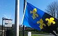
Flag of Monmouthshire

Last updated
Monmouthshire
Flag of Monmouthshire.svg
Proportion3:5
Adopted30 September 2011
DesignPer pale Azure and Sable three fleurs-de-lys Or
Designed byThe Monmouthshire Association

The Monmouthshire flag (Welsh : Baner Sir Fynwy) is the flag of the historic county of Monmouth. It was registered with the Flag Institute as the official flag of the county in 2011 [1] although its origins date back to the 6th century.

Contents

History

Coat of arms of the Monmouthshire County Council Arms of Monmouthshire County Council.svg
Coat of arms of the Monmouthshire County Council

The arms are those attributed by medieval heralds to King Inyr of the Welsh Kingdom of Gwent, from which Monmouthshire, once known as Wentset and Wentsland, descends. The County Council of Monmouth were first granted the arms in 1948 and they have been incorporated into the arms of other bodies over the succeeding years. This is a pattern long associated with Monmouthshire and it is also used today in the shield of the Diocese of Monmouth and in those of Monmouthshire Council, Blaenau Gwent Council and the Monmouthshire County RFC.

Design

The pantone colours for the flag are:

Armorial banner

Flag used by Monmouthshire Council Monmouthshire Council flag.png
Flag used by Monmouthshire Council

Monmouthshire Council, which administers the principal area of Monmouthshire in the eastern part of the traditional county, uses a white banner charged with its coat of arms. [2]

Related Research Articles

Monmouth Town in Monmouthshire, Wales

Monmouth is a town and community in Wales. It is situated where the River Monnow joins the River Wye, 2 miles (3.2 km) from the Wales–England border. Monmouth is 30 miles (48 km) northeast of Cardiff, and 113 miles (182 km) west of London. It is within the Monmouthshire local authority, and the parliamentary constituency of Monmouth. The population in the 2011 census was 10,508, rising from 8,877 in 2001. Monmouth is the historic county town of Monmouthshire although Abergavenny is now the county town.

Chepstow Human settlement in Wales

Chepstow is a town and community in Monmouthshire, Wales, adjoining the border with Gloucestershire, England. It is located on the tidal River Wye, about 2 miles (3.2 km) above its confluence with the River Severn, and adjoining the western end of the Severn Bridge. It is the easternmost settlement in Wales, situated 16 miles (26 km) east of Newport, 28 miles (45 km) east-northeast of Cardiff, 18 miles (29 km) northwest of Bristol and 110 miles (180 km) west of London.

Torfaen County borough in Wales

Torfaen is a county borough in the south-east of Wales. Torfaen is bordered by the county of Monmouthshire to the east, the city of Newport to the south, and the county boroughs of Caerphilly and Blaenau Gwent to the south-west and north-west respectively. It is within the historic boundaries of the historic county of Monmouthshire, and between 1974 and 1996 was a district of Gwent, until it was reconstituted as a principal area in 1996.

Monmouthshire County in Wales

Monmouthshire is a county in the south-east of Wales. The name derives from the historic county of the same name; the modern county covers the eastern three-fifths of the historic county. The largest town is Abergavenny, with other towns and large villages being: Caldicot, Chepstow, Monmouth, Magor and Usk. It borders Torfaen, Newport and Blaenau Gwent to the west; Herefordshire and Gloucestershire to the east; and Powys to the north.

Monmouthshire (historic) Historic county in Wales

Monmouthshire, also known as the County of Monmouth, is one of thirteen historic counties of Wales and a former administrative county. It corresponds approximately to the present principal areas of Monmouthshire, Blaenau Gwent, Newport and Torfaen, and those parts of Caerphilly and Cardiff east of the Rhymney River.

Monmouth (UK Parliament constituency) Parliamentary constituency in the United Kingdom, 1918 onwards

Monmouth is a county constituency of the House of Commons of the Parliament of the United Kingdom. The seat was created for the 1918 general election. Since 2005 the Member of Parliament (MP) has been David Davies of the Conservative Party.

Monmouthshire County Council Local government of Monmouthshire, Wales

Monmouthshire County Council is the governing body for the Monmouthshire principal area – one of the unitary authorities of Wales.

Kingdom of Gwent Kingdom in South Wales

Gwent was a medieval Welsh kingdom, lying between the Rivers Wye and Usk. It existed from the end of Roman rule in Britain in about the 5th century until the Norman invasion of Wales in the 11th century. Along with its neighbour Glywyssing, it seems to have had a great deal of cultural continuity with the earlier Silures, keeping their own courts and diocese separate from the rest of Wales until their conquest by Gruffydd ap Llywelyn. Although it recovered its independence after his death in 1063, Gwent was the first of the Welsh kingdoms to be overrun following the Norman conquest.

Gwent (preserved county) Preserved county in south-east Wales

Gwent is a preserved county and former local government county in southeast Wales. A county of Gwent was formed on 1 April 1974, under the Local Government Act 1972; it was named after the ancient Kingdom of Gwent. The authority was a successor to both the administrative county of Monmouthshire and the county borough of Newport. In forming the county of Gwent the act explicitly resolved the previously somewhat ambiguous status of the latter two authorities, in terms of whether they were a part of Wales or England.

Dingestow Human settlement in Wales

Dingestow is a small village in Monmouthshire, Wales. It is located 4 miles (6.4 km) south-west of Monmouth and approximately the same distance north-east of Raglan in rural Monmouthshire. The River Trothy passes through the village.

Rockfield, Monmouthshire Human settlement in Wales

Rockfield is a small village in Monmouthshire, Southeast Wales. It is located beside the River Monnow, about 2 miles (3.2 km) north-west of Monmouth, at the junction of the B4233 to Abergavenny and the B4347 to Grosmont. Rockfield Studios is situated just south of the village.

Monmouth Town Football Club is a Welsh football club based in the historic town of Monmouth. The club plays in the Ardal Leagues South East, tier 3 of the Welsh football pyramid.

Croft-Y-Bwla

Croft-Y-Bwla is a country house and farm 1.5 miles (2.4 km) north-west of Monmouth, south-east Wales. The house was built around 1830 and was designed by the noted Monmouth architect George Vaughan Maddox. It has been listed as Grade II since 1974.

Monmouth town walls and defences

The Monmouth town walls and defences comprise the defensive system of town walls and gates built in Monmouth, Wales between 1297 and the early part of the following century. Wye Bridge Gate, East Gate, Monk's Gate, and Monnow Bridge Gate were access points to the town. West Gate, across Monnow Street, also provided access. Only the Monnow Bridge Gatehouse survives intact, albeit in a substantially modified version from the original.

33 Whitecross Street, Monmouth

33 Whitecross Street is a grade II listed building in Monmouth, Monmouthshire, Wales. It is in the historic St James Square neighbourhood. The property was the site of archaeological excavation in 2009, which demonstrated evidence of Neolithic (prehistoric), Roman, and Medieval activity. The following year, archaeological excavation in the square discovered the first evidence of Mesolithic human settlement in Monmouth.

Monmouth Comprehensive School is a comprehensive secondary school for pupils aged 11–18, situated in Monmouth, Monmouthshire, Wales.

Monmouth Police Station

The Monmouth Police Station is a Grade II listed building in the town centre of Monmouth, Monmouthshire, Wales. It is located in the historic Glendower Street neighbourhood, within the medieval town walls. In March 2012, it was announced that the Monmouth Police Station was one of seventeen police stations in South East Wales that would no longer be open to the public.

<i>Pontypool Free Press</i>

The Pontypool Free Press is an English language weekly regional newspaper that was originally published in Pontypool, as the Pontypool Free Press and Herald of the Hills, in 1859 and is circulated in Pontypool and the surrounding area of Torfaen, in south-east Wales.

Peter Fox (Welsh politician) British Conservative politician

Peter Alan Fox OBE is a British Conservative politician who is the Shadow Minister for Finance in the Senedd. Fox was Leader of Monmouthshire County Council from 2008 until May 2021, when he was elected as a Member of the Senedd (MS) for the Monmouth constituency.

References

  1. "Monmouthshire Flag Registered". Association of British Counties. 30 September 2011. Archived from the original on 11 September 2012.
  2. "As one door closes... | abergavennychronicle.com". Abergavenny Chronicle. April 11, 2012.