
Tamaulipas, officially the Free and Sovereign State of Tamaulipas, is a state in Mexico; one of the 31 states which, along with Mexico City, comprise the 32 Federal Entities of Mexico. It is divided into 43 municipalities.

Coahuila y Tejas, officially the Estado Libre y Soberano de Coahuila y Tejas, was one of the constituent states of the newly established United Mexican States under its 1824 Constitution.

José de Escandón y Helguera, conde de Sierra was a Spanish Indian-fighter in New Spain and the founder and first governor of the colony of Nuevo Santander, which extended from the Pánuco River in the modern-day Mexican state of Tamaulipas to the Guadalupe River in the modern-day U.S. state of Texas.

Nuevo Laredo is a city in the Municipality of Nuevo Laredo in the Mexican state of Tamaulipas. The city lies on the banks of the Rio Grande, across from Laredo, United States. The 2010 census population of the city was 373,725. Nuevo Laredo is part of the Laredo-Nuevo Laredo Metropolitan Area with a population of 636,516. The municipality has an area of 1,334.02 km2 (515.07 sq mi). Nuevo Laredo is considered the “customs capital of Latin America” because of its high volume of international trade operations in the region, and number 1 in importance for US inland commercial traffic. Both the city and the municipality rank as the third largest in the state.

"Six flags over Texas" is the slogan used to describe the six sovereign countries that have had control over some or all of the current territory of the U.S. state of Texas: Spain, France (1685–1690), Mexico (1821–1836), the Republic of Texas (1836–1845), the United States, and the Confederate States (1861–1865).

The Republic of the Rio Grande was one of a series of political movements in Mexico which sought to become independent from the unitary government dominated by Antonio López de Santa Anna; the Republic of Texas and the second Republic of Yucatán were created by political movements that pursued the same goal. Insurgents fighting against the Centralist Republic of Mexico sought to establish the Republic of the Rio Grande as an independent nation in Northern Mexico. The rebellion lasted from 17 January to 6 November 1840.
Federal Highway 2 is a free part of the Mexican federal highway corridors that runs along the U.S. border. The highway is in two separate improved segments, starting in the west at Tijuana, Baja California, on the Pacific coast and ending in the east in Matamoros, Tamaulipas, on the Gulf of Mexico. Fed. 2 passes through the border states of Baja California, Sonora, Chihuahua, Coahuila, Nuevo Leon and Tamaulipas. It has a total length of 1,987 kilometres (1,235 mi); 1,343 kilometres (835 mi) in the west and 644 kilometres (400 mi) in the east.
The flag of the Republic of the Rio Grande was used in 1840, during 283 days from January 17 to November 6, as long as the republic existed. This country was formed by the northeastern Mexican states of Coahuila, Nuevo León, and Tamaulipas. The flag was no longer used following the defeat of the Republic of the Rio Grande by Mexican troops.

Colombia is a planned community founded in 1992 by the Mexican state of Nuevo León in the Anáhuac Municipality. It lies on the southern banks of the Río Grande, across from the U.S. city of Laredo, Texas. According to the INEGI Census, in 2010 Colombia had a population of 514.

The Laredo–Colombia Solidarity International Bridge is one of four vehicular international bridges located on the U.S.–Mexico border in the city of Laredo, Texas; it connects Laredo over the Rio Grande with Colombia, Nuevo León. It is owned and operated by the City of Laredo and the Secretaría de Comunicaciones y Transportes.
The World Trade International Bridge is one of four international bridges located in the cities of Laredo, Texas, and Nuevo Laredo, Tamaulipas, that connect the United States and Mexico over the Rio Grande. It is owned and operated by City of Laredo and the Secretaría de Comunicaciones y Transportes. It is also known as Laredo International Bridge 4.
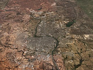
Laredo–Nuevo Laredo, otherwise known as the "Four-State Area" or the "Quad State Area", is one of six transborder agglomerations along the U.S.-Mexican border. The city of Laredo is situated in the U.S. state of Texas on the northern bank of the Rio Grande and Nuevo Laredo is located in the Mexican State of Tamaulipas in the southern bank of the river. This area is also known as the Two Laredos or the Laredo Borderplex. The area is made up of one county in the U.S and three municipalities in Mexico. Two urban areas, three cities, and 12 towns make the Laredo–Nuevo Laredo Metropolitan area. The two sides of the Borderplex are connected by four International Bridges and an International Railway Bridge. The Laredo–Nuevo Laredo Metropolitan area has a total of 636,516 inhabitants according to the INEGI Census of 2010 and the United States Census estimate of 2010. According to World Gazetteer this urban agglomeration ranked 157th largest in North and South America in 2010 with an estimated population of 675,481. This area ranks 66th in the United States and 23rd in Mexico.
Antonio Canales Rosillo was a 19th-century Mexican politician, surveyor, and military officer also known for co-founding the short-lived Republic of the Rio Grande.

Tomás Sánchez de la Barrera was a veteran Spanish captain who founded Laredo, Texas, United States, and Nuevo Laredo, Tamaulipas, Mexico, the only town in the Nuevo Santander province.

Hurricane Alex was the first tropical cyclone of the 2010 Atlantic hurricane season, and a rare June Atlantic hurricane. Originating from an area of disturbed weather on June 25, 2010, it slowly developed in the western Caribbean Sea and struck Belize as a strong tropical storm. After entering the Gulf of Mexico, Alex became very large and encountered conditions favorable for gradual development. Early on June 30, the cyclone attained hurricane status as it approached northeastern Mexico, the first June hurricane in the Atlantic basin since Hurricane Allison in 1995, and the storm rapidly intensified just off the coast of Tamaulipas. Alex made landfall near Soto la Marina as a Category 2 hurricane on the Saffir-Simpson Hurricane Wind Scale. Alex rapidly weakened after landfall, with the storm losing its tropical status on July 2, before fully dissipating on July 6.
Most Mexican states do not have an official flag. For these states, a de facto flag is used for civil and state purposes. State flags of Mexico have a 4:7 ratio and typically consist of a white background charged with the state's coat of arms.
Jesús de Cárdenas Duarte was the Governor of Tamaulipas and the President of the Republic of the Rio Grande.
The International Railway Bridge crosses the Niagara River between Fort Erie, Ontario, Canada and Buffalo, New York, United States

