
Root is a town in Montgomery County, New York, United States. The population was 1,715 at the 2010 census. The town was named for Erastus Root, a legislator in the early Federal period.

The Mohawk River is a 149-mile-long (240 km) river in the U.S. state of New York. It is the largest tributary of the Hudson River. The Mohawk flows into the Hudson in Cohoes, New York, a few miles north of the state capital of Albany. The river is named for the Mohawk Nation of the Iroquois Confederacy. A major waterway, in the early 19th century, the river's east-west valley provided the setting and water for development of the Erie Canal, as a key to developing New York. The largest tributary, the Schoharie Creek, accounts for over one quarter (26.83%) of the Mohawk River's watershed. Another main tributary is the West Canada Creek, which makes up for 16.33% of the Mohawk's watershed.

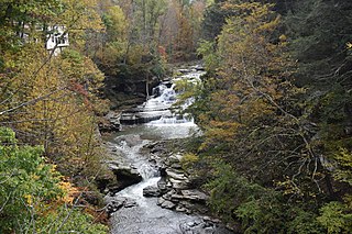
Schoharie Creek is a river in New York that flows north 93 miles (150 km) from the foot of Indian Head Mountain in the Catskills through the Schoharie Valley to the Mohawk River. It is twice impounded north of Prattsville to create New York City's Schoharie Reservoir and the Blenheim-Gilboa Power Project.

The West Canada Creek is a 76-mile-long (122 km) river in upstate New York, United States. West Canada Creek is an important water way in Hamilton, Oneida, and Herkimer counties, draining the south part of the Adirondack Mountains before emptying into the Mohawk River near the Village of Herkimer. The name "Canada" is derived from an Iroquoian word for "village" (Kanata).

Fox Creek is a 24.8-mile-long (39.9 km) tributary of Schoharie Creek in Schoharie and Albany counties in the U.S. state of New York. It rises in the southeastern part of the town of Berne, west of the Helderberg Mountains, and flows west, passing through the hamlets of East Berne, Bensons Corner, Berne, and West Berne, continuing through the town of Wright, where it passes the hamlets of Gallupville and Shutter Corners before entering the town of Schoharie, where it flows into Schoharie Creek near the hamlet of Vroman Corners. Fox Creek is part of the Hudson River watershed, Via Schoharie Creek and the Mohawk River.
Otsquago Creek is a river that enters the Mohawk River in Fort Plain, New York. Otsquago is a Mohawk Indian word meaning 'under the bridge,' probably referring to an early bridge of felled trees along the creek, a way of making small bridges. It is also referred to as Otsquage on old maps, which is an Indian word for 'healing waters'.

The Canajoharie Creek is a river that flows into the Mohawk River in the Village of Canajoharie in the U.S. State of New York. The name "Canajoharie" is a Mohawk language term meaning "the pot that washes itself", referring to the "Canajoharie Boiling Pot", a 20-foot (6.1 m) wide and 10-foot (3.0 m) deep pothole in the Canajoharie Creek, just south of the village of Canajoharie. Bowmans Creek is one main tributary that enters the creek east of the Hamlet of Sprout Brook. The other main tributary is Brimstone Creek which enters the creek north-northwest of the Village of Ames.
Fulmer Creek is an 11.5-mile-long (18.5 km) river that flows into the Mohawk River in Mohawk, New York. The creek derives its name from the "Fulmer" family, who bought land through the Burnetsfield patent of 1725, in which lands on the present village site were granted out.
Burch Creek is a river in Herkimer County in the state of New York. It flows into the Mohawk River east of West Schuyler.
Sterling Creek is a river located in Herkimer County in the U.S. State of New York. It flows into the Mohawk River east-southeast of the Hamlet of West Schuyler.
Pratt Creek is a river in Herkimer County in the state of New York. It flows into the Mohawk River near Frankfort.
Caroga Creek is a river in Fulton and Montgomery counties in the U.S. State of New York. It begins at East Caroga Lake and flows south passing through Rockwood Lake before converging with the Mohawk River in the Hamlet of Palatine Church.
Kayaderosseras Creek also called Kaniatarósera'as Stream is a river located in Montgomery and Fulton counties in the state of New York. The creek begins southeast of Johnstown and flows in a generally southeast direction before converging with the Mohawk River by Fort Johnson, just west of Amsterdam. Kaniatarósera'as Stream, is a Mohawk name which translates to "waves splashing".
East Kill, a 16-mile-long (26 km) tributary of Schoharie Creek, flows across the town of Jewett, New York, United States, from its source on Stoppel Point. Ultimately its waters reach the Hudson River via the Mohawk. Since it drains into the Schoharie upstream of Schoharie Reservoir, it is part of the New York City water supply system. East Kill drains the southern slopes of the Blackhead Mountains, which include Thomas Cole Mountain, Black Dome, and Blackhead Mountain, the fourth-, third-, and fifth-highest peaks in the Catskills, respectively.

The West Kill, an 11-mile-long (18 km) tributary of Schoharie Creek, flows through the town of Lexington, New York, United States, from its source on Hunter Mountain, the second-highest peak of the Catskill Mountains. Ultimately its waters reach the Hudson River via the Mohawk. Since it drains into the Schoharie upstream of Schoharie Reservoir, it is part of the New York City water supply system. It lends its name to both a mountain to its south and a small town midway along its length.

Batavia Kill is a 21-mile-long (34 km) tributary of Schoharie Creek, that flows across the towns of Windham, Ashland and Prattsville in the U.S. state of New York. Its waters reach the Hudson River via Schoharie Creek and the Mohawk River. Since it drains into the Schoharie upstream of Schoharie Reservoir, it is part of the New York City water supply system. From the source to Maplecrest, Batavia Kill drains the northern slopes of the Blackhead Mountains, which include Thomas Cole Mountain, Black Dome, and Blackhead Mountain, the fourth-, third-, and fifth-highest peaks in the Catskills, respectively.
Fly Creek is a river in Montgomery and Schoharie counties in the state of New York. It begins at an unnamed swamp north of Sloansville and flows into the Schoharie Creek south of Sloansville.
Bridenbecker Creek is a river in Herkimer County in the state of New York. It flows into the Mohawk River by Frankfort. Bridenbecker Creek is named after the Bridenbecker family who had a farm in the area in the 1800s.
Knapp Brook is a river that flows into the Mohawk River by West Schuyler, New York.
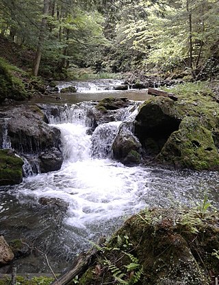
Manor Kill is a river in Schoharie County in the state of New York. It begins northeast of Manorkill and flows westward before flowing into the Schoharie Reservoir southeast of Gilboa, New York. Manor Kill Falls is located on the creek where it passes under Prattsville Road. Since it drains into the Schoharie Reservoir, it is part of the New York City water supply system.

