Flitwick is a town and civil parish in Central Bedfordshire, England. It is mentioned in the Domesday Book of 1086 as "a hamlet on the River Flitt". The spelling Flytwyk appears in 1381.

Toddington is a large village and civil parish in the county of Bedfordshire, England. It is situated 5 miles north-north-west of Luton, 4 miles (6 km) north of Dunstable, 6 miles (10 km) south-west of Woburn, and 35 miles north-north-west of London on the B5120 and B579. It is 0.5 miles from Junction 12 of the M1 motorway and lends its name to the nearby motorway service station. The hamlet of Fancott also forms part of the Toddington civil parish.

Mid Bedfordshire is a constituency represented in the House of Commons of the UK Parliament by Alistair Strathern of the Labour Party since a 2023 by-election.

The Wildlife Trust for Bedfordshire, Cambridgeshire and Northamptonshire (WTBCN) is a registered charity which manages 126 nature reserves covering 3,945 hectares. It has over 35,000 members, and 95% of people in Bedfordshire, Cambridgeshire and Northamptonshire live within five miles of a reserve. In the year to 31 March 2016 it employed 105 people and had an income of £5.1 million. It aims to conserve wildlife, inspire people to take action for wildlife, offer advice and share knowledge. The WTBCN is one of 36 wildlife trusts covering England, and 46 covering the whole of the United Kingdom.

Cooper's Hill is an 18.1-hectare (45-acre) biological Site of Special Scientific Interest in Ampthill in Bedfordshire. It was notified under Section 28 of the Wildlife and Countryside Act 1981 in 1984, and the planning authority is Central Bedfordshire Council. A smaller area of 12.7 hectares is also a Local Nature Reserve, Part of the site is managed by the Wildlife Trust for Bedfordshire, Cambridgeshire and Northamptonshire.
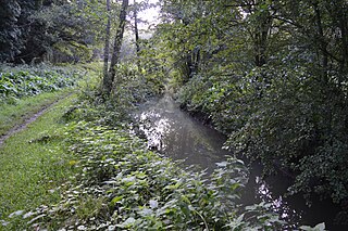
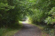
Flitwick Moor is a 59.8-hectare (148-acre) biological Site of Special Scientific Interest between Flitwick and Greenfield in Bedfordshire. It was notified under Section 28 of the Wildlife and Countryside Act 1981 in 1984 and the local planning authority is Central Bedfordshire Council. The site is managed by the Wildlife Trust for Bedfordshire, Cambridgeshire and Northamptonshire.

Totternhoe Knolls is a 13.1-hectare (32-acre) Site of Special Scientific Interest (SSSI) in Totternhoe in Bedfordshire. It is also a local nature reserve, and part of the Chilterns Area of Outstanding Natural Beauty. The site is owned by Central Bedfordshire Council and leased to the National Trust. Most of the site is maintained jointly by the National Trust and the Wildlife Trust for Bedfordshire, Cambridgeshire and Northamptonshire (WTBCN), and is part of the WTBCN Totternhoe nature reserve, which also includes Totternhoe Chalk Quarry and Totternhoe Stone Pit. The SSSI also includes Totternhoe Castle, the earthworks of a Norman motte-and-bailey castle which is a Scheduled monument.
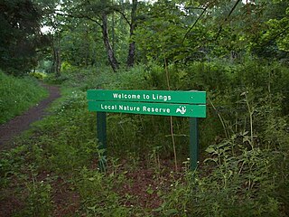
Lings Wood is a 20.1 hectare Local Nature Reserve in eastern Northampton. It is owned by Northampton Borough Council and managed by the Wildlife Trust for Bedfordshire, Cambridgeshire and Northamptonshire.

Kings and Bakers Woods and Heaths is a 212.8-hectare (526-acre) Site of Special Scientific Interest (SSSI) between Heath and Reach in Bedfordshire and Great Brickhill in Buckinghamshire. The site is mainly in Bedfordshire but includes Rammamere Heath in Buckinghamshire. It was notified in 1984 under Section 28 of the Wildlife and Countryside Act 1981, and the local planning authorities are Central Bedfordshire Council and Aylesbury Vale Council. Part of it is a National Nature Reserve, and part of it is a nature reserve managed by the Wildlife Trust for Bedfordshire, Cambridgeshire and Northamptonshire. it is also a Nature Conservation Review site.

Kings Wood and Glebe Meadows is a 36.1-hectare (89-acre) Site of Special Scientific Interest in Houghton Conquest in Bedfordshire. A local teenage boy, Peter Sollars, discovered many rich communities of plants there, including a number of rare species, e.g. Butcher's Broom, Small Teasel and Green Hellebore in the wood, and combinations of Lady's Bedstraw, Spiny Restharrow, Great Burnet, Adders Tongue Fern and Cowslips in the meadows. The County Botanist at the time, John Dony, was notified of his findings, which were confirmed by a site visit with Peter. The site was notified in 1984 under the Wildlife and Countryside Act 1981, and the planning authority is Central Bedfordshire. It is also a Local Nature Reserve.

Marston Thrift is a 37.4-hectare (92-acre) biological Site of Special Scientific Interest between Marston Moretaine and Cranfield in Bedfordshire. It was notified in 1984 under Section 28 of the Wildlife and Countryside Act 1981, and the local planning authority is Central Bedfordshire Council. It is also a Local Nature Reserve, which extends to a larger area of 55.8 hectares.

Maulden Church Meadow is a 4.1-hectare (10-acre) biological Site of Special Scientific Interest in Maulden in Bedfordshire. It was notified in 1987 under section 28 of the Wildlife and Countryside Act 1981, and the local planning authority is Central Bedfordshire Council. Most of it is also a Local Nature Reserve, owned and managed by Central Bedfordshire Council.

Cottage Bottom Fields is a 14.1 hectare local nature reserve in Dunstable in Bedfordshire. It is owned and managed by Central Bedfordshire Council.

Browns Wood is a six hectare Local Nature Reserve north of Clapham in Bedfordshire. It is owned and managed by Bedford Borough Council.
King's Wood is a 31.7 hectare Local Nature Reserve in Corby in Northamptonshire. It managed by the Wildlife Trust for Bedfordshire, Cambridgeshire and Northamptonshire.

Bradlaugh Fields is a 60-hectare (150-acre) open space in Northampton. The site is a former golf course. In 1987 it was proposed to build housing on the site, but after a campaign by local residents it was acquired by Northampton Borough Council and opened as a wildlife park in 1998. It was named after Charles Bradlaugh, a leading nineteenth century radical and atheist who was MP for Northampton. Three fields with a total area of 17.5 hectares are managed by the Wildlife Trust for Bedfordshire, Cambridgeshire and Northamptonshire as a nature reserve also called Bradlaugh Fields. Hills and Holes is at the southern end and two adjoining meadows, Scrub Field and Quarry Field, are at the northern end. Hills and Holes is an 8.3 hectare Local Nature Reserve (LNR) and Scrub Field is a 5.1-hectare (13-acre) LNR.