
Toddington is a large village and civil parish in the county of Bedfordshire, England. It is situated 5 miles north-north-west of Luton, 4 miles (6 km) north of Dunstable, 6 miles (10 km) south-west of Woburn, and 35 miles north-north-west of London on the B5120 and B579. It is 0.5 miles from Junction 12 of the M1 motorway and lends its name to the nearby motorway service station. The hamlet of Fancott also forms part of the Toddington civil parish.

Whipsnade is a small village and civil parish in the county of Bedfordshire, England. It lies on the eastward tail spurs of the Chiltern Hills, about 4.2 km south-south-west of Dunstable on the top of the Dunstable Downs which drop away steeply to the south of the village.

Dunstable is a market town and civil parish in Bedfordshire, England, east of the Chiltern Hills, 30 miles north of London. There are several steep chalk escarpments, most noticeable when approaching Dunstable from the north. Dunstable is the fourth largest town in Bedfordshire and along with Houghton Regis forms the westernmost part of the Luton/Dunstable Urban Area.
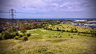
Blow's Down is a 33.1 hectare biological Site of Special Scientific Interest in Dunstable in Bedfordshire. It was notified in 1989 under Section 28 of the Wildlife and Countryside Act 1981, and the local planning authority is Central Bedfordshire Council. The site forms around half of the 62.3 hectare Blow's Downs nature reserve, which is managed by the Wildlife Trust for Bedfordshire, Cambridgeshire and Northamptonshire.

Cooper's Hill is an 18.1 hectare biological Site of Special Scientific Interest in Ampthill in Bedfordshire. It was notified under Section 28 of the Wildlife and Countryside Act 1981 in 1984, and the planning authority is Central Bedfordshire Council. A smaller area of 12.7 hectares is also a Local Nature Reserve, Part of the site is managed by the Wildlife Trust for Bedfordshire, Cambridgeshire and Northamptonshire.

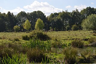
Dropshort Marsh is a 2.7 hectare biological Site of Special Scientific Interest in Toddington in Bedfordshire. It was notified under Section 28 of the Wildlife and Countryside Act 1981 in 1985, and the local planning authority is Central Bedfordshire Council. The site is managed by the Wildlife Trust for Bedfordshire, Cambridgeshire and Northamptonshire.

King's Wood is an area of ancient woodland in the parish of Heath and Reach in Bedfordshire, England. The wood lies north of the village of Heath and Reach and east of Great Brickhill and with neighboring Bakers Wood forms the largest area of ancient woodland in Bedfordshire. Much of the wood lies within Kings Wood and Rushmere National Nature Reserve, jointly owned and managed by the Greensand Trust, Wildlife Trust for Bedfordshire, Cambridgeshire and Northamptonshire, Central Bedfordshire Council and Tarmac Aggregates. Kings Wood and many parts of the National Nature Reserve are part of a Site of Special Scientific Interest named Kings and Bakers Woods and Heaths, which also includes Rammamere Heath in Buckinghamshire and Shire Oak Heath in Bedfordshire.

Totternhoe Knolls is a 13.1 hectare Site of Special Scientific Interest (SSSI) in Totternhoe in Bedfordshire. It is also a local nature reserve, and part of the Chilterns Area of Outstanding Natural Beauty. The site is owned by Central Bedfordshire Council and leased to the National Trust. Most of the site is maintained jointly by the National Trust and the Wildlife Trust for Bedfordshire, Cambridgeshire and Northamptonshire (WTBCN), and is part of the WTBCN Totternhoe nature reserve, which also includes Totternhoe Chalk Quarry and Totternhoe Stone Pit. The SSSI also includes Totternhoe Castle, the earthworks of a Norman motte-and-bailey castle which is a Scheduled monument.

Totternhoe Stone Pit is a geological Site of Special Scientific Interest in Totternhoe in Bedfordshire, England. It is also a Geological Conservation Review site, and the local planning authority is Central Bedfordshire Council.

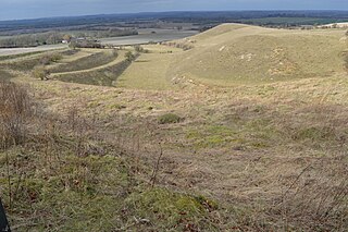
Dunstable and Whipsnade Downs is a 73.4 hectare Site of Special Scientific Interest in Dunstable in Bedfordshire. It was notified in 1987 under Section 28 of the Wildlife and Countryside Act 1981, and the local planning authority is Central Bedfordshire Council. It is in the Chilterns Area of Outstanding Natural Beauty, and part of it is owned by the National Trust.

Kings and Bakers Woods and Heaths is a 212.8 hectare Site of Special Scientific Interest (SSSI) between Heath and Reach in Bedfordshire and Great Brickhill in Buckinghamshire. The site is mainly in Bedfordshire but includes Rammamere Heath in Buckinghamshire. It was notified in 1984 under Section 28 of the Wildlife and Countryside Act 1981, and the local planning authorities are Central Bedfordshire Council and Aylesbury Vale Council. Part of it is a National Nature Reserve, and part of it is a nature reserve managed by the Wildlife Trust for Bedfordshire, Cambridgeshire and Northamptonshire. it is also a Nature Conservation Review site.
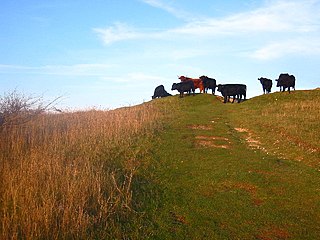
Knocking Hoe is a 7.7 hectare National Nature Reserve and biological Site of Special Scientific Interest near Pegsdon in Bedfordshire. It is mentioned in A Nature Conservation Review. It is part of the Chilterns Area of Outstanding Natural Beauty, and is managed by Natural England.
Galley and Warden Hills is a 47 hectare biological Site of Special Scientific Interest in Warden Hill, a suburb of Luton in Bedfordshire. The local planning authority is Central Bedfordshire Council, and it was notified in 1986 under Section 28 of the Wildlife and Countryside Act 1981. It is also a Local Nature Reserve.

Marston Thrift is a 37.4 hectare biological Site of Special Scientific Interest between Marston Moretaine and Cranfield in Bedfordshire. It was notified in 1984 under Section 28 of the Wildlife and Countryside Act 1981, and the local planning authority is Central Bedfordshire Council. It is also a Local Nature Reserve, which extends to a larger area of 55.8 hectares.

Maulden Church Meadow is a 4.1 hectare biological Site of Special Scientific Interest in Maulden in Bedfordshire. It was notified in 1987 under section 28 of the Wildlife and Countryside Act 1981, and the local planning authority is Central Bedfordshire Council. Most of it is also a Local Nature Reserve, owned and managed by Central Bedfordshire Council.

Totternhoe nature reserve is managed by the Wildlife Trust for Bedfordshire, Cambridgeshire and Northamptonshire (WTBCN). The 31 hectare site is in Totternhoe in Bedfordshire, and it includes parts of three Sites of Special Scientific Interest (SSSIs). Totternhoe Knolls is a biological SSSI owned by Central Bedfordshire Council and leased to the National Trust. Most of it is managed jointly by the National Trust and the WTBCN, excluding Totternhoe Castle, the earthworks of a Norman motte-and-bailey castle which is part of the SSSI but not of WTBCN's nature reserve. Totternhoe nature reserve also includes the geological SSSI, Totternhoe Stone Pit, which is not open to the public, and other areas owned by WTBCN, including part of Totternhoe Chalk Quarry, another biological SSSI.
Flitton Moor is a 6.9 hectare Local Nature Reserve and County Wildlife Site in Flitton in Bedfordshire. It is owned by Central Bedfordshire Council and managed by the council together with The Greensand Trust.

Flitwick Wood is a 14.2 hectares Local Nature Reserve in Flitwick in Bedfordshire. It is owned and managed by Central Bedfordshire Council.
