The Delta Works is a series of construction projects in the southwest of the Netherlands to protect a large area of land around the Rhine–Meuse–Scheldt delta from the sea. Constructed between 1954 and 1997, the works consist of dams, sluices, locks, dykes, levees, and storm surge barriers located in the provinces of South Holland and Zeeland.
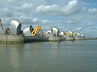
The Thames Barrier is a retractable barrier system built to protect the floodplain of most of Greater London from exceptionally high tides and storm surges moving up from the North Sea. It has been operational since 1982. When needed, it is closed (raised) during high tide; at low tide, it can be opened to restore the river's flow towards the sea. Built about 2 miles east of the Isle of Dogs, its northern bank is in Silvertown in the London Borough of Newham and its southern bank is in the New Charlton area of the Royal Borough of Greenwich.

Storm tides of the North Sea are coastal floods associated with extratropical cyclones crossing over the North Sea, the severity of which is affected by the shallowness of the sea and the orientation of the shoreline relative to the storm's path, as well as the timing of tides. The water level can rise to more than 5 metres (17 ft) above the normal tide as a result of storm tides.
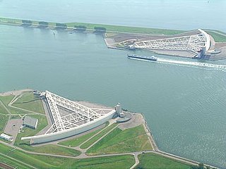
The Maeslantkering is a storm surge barrier on the Nieuwe Waterweg, in South Holland, Netherlands. It was constructed from 1991 to 1997. As part of the Delta Works the barrier responds to water level predictions calculated by a centralized computer system called BOS. It automatically closes when Rotterdam is threatened by floods.

The 1938 New England Hurricane was one of the deadliest and most destructive tropical cyclones to strike the United States. The storm formed near the coast of Africa on September 9, becoming a Category 5 hurricane on the Saffir–Simpson hurricane scale, before making landfall as a Category 3 hurricane on Long Island on Wednesday, September 21. It is estimated that the hurricane killed 682 people, damaged or destroyed more than 57,000 homes, and caused property losses estimated at $306 million. Multiple other sources, however, mention that the 1938 hurricane might have really been a more powerful Category 4, having winds similar to Hurricanes Hugo, Harvey, Frederic and Gracie when it ran through Long Island and New England. Also, numerous others estimate the real damage between $347 million and almost $410 million. Damaged trees and buildings were still seen in the affected areas as late as 1951. It remains the most powerful and deadliest hurricane in recorded New England history, perhaps eclipsed in landfall intensity only by the Great Colonial Hurricane of 1635.

A storm surge, storm flood, tidal surge, or storm tide is a coastal flood or tsunami-like phenomenon of rising water commonly associated with low-pressure weather systems, such as cyclones. It is measured as the rise in water level above the normal tidal level, and does not include waves.

The 1953 North Sea flood was a major flood caused by a heavy storm surge that struck the Netherlands, north-west Belgium, England and Scotland. Most sea defences facing the surge were overwhelmed, resulting in extensive flooding.

A flood barrier, surge barrier or storm surge barrier is a specific type of floodgate, designed to prevent a storm surge or spring tide from flooding the protected area behind the barrier. A surge barrier is almost always part of a larger flood protection system consisting of floodwalls, levees, and other constructions and natural geographical features.

St. Lucia's flood (Sint-Luciavloed) was a storm tide that affected the Netherlands and Northern Germany on 13/14 December 1287 (OS), St. Lucia Day and the day after, killing approximately 50,000 to 80,000 people in one of the largest floods in recorded history. A low-pressure system mixed with a high tide caused the North Sea to rise over the seawalls and dikes, causing a large portion of the Netherlands and Northern Germany to be flooded.
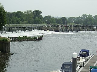
The Tideway is the part of the River Thames in England which is subject to tides. This stretch of water is downstream from Teddington Lock. The Tideway comprises the upper Thames Estuary including the Pool of London.
The 1928 Thames flood was a disastrous flood of the River Thames that affected much of riverside London on 7 January 1928, as well as places further downriver. Fourteen people died and thousands were made homeless when floodwaters poured over the top of the Thames Embankment and part of the Chelsea Embankment collapsed. It was the last major flood to affect central London, and, along with the disastrous North Sea flood of 1953, helped lead to the implementation of new flood control measures that culminated in the construction of the Thames Barrier in the 1970s.

Flood is a 2007 British-Canadian disaster film, directed by Tony Mitchell. It features Robert Carlyle, Jessalyn Gilsig, David Suchet and Tom Courtenay and is mainly set in London, England. It is based on the novel of the same name by Richard Doyle.

Cyclone Tilo was a European windstorm which affected northern and western Europe in early November 2007. Combining with the remnants of Hurricane Noel, Tilo's storm surge led to the North Sea flood of 2007, affecting the coastlines of the Netherlands, the United Kingdom, Germany, Denmark, Norway and Belgium, starting on the night of 8–9 November 2007.

Coastal flooding occurs when dry and low-lying land is submerged (flooded) by seawater. The range of a coastal flooding is a result of the elevation of floodwater that penetrates the inland which is controlled by the topography of the coastal land exposed to flooding. The seawater can flood the land via several different paths: direct flooding, overtopping of a barrier, or breaching of a barrier. Coastal flooding is largely a natural event. Due to the effects of climate change and an increase in the population living in coastal areas, the damage caused by coastal flood events has intensified and more people are being affected.

The December 1992 nor'easter produced record high tides and snowfall across the northeastern United States. It developed as a low pressure area on December 10 over Virginia, and for two days it remained over the Mid-Atlantic states before moving offshore. In Maryland, the snowfall unofficially reached 48 in (1,200 mm); if verified, the total would have been the highest in the state's history. About 120,000 people were left without power in the state due to high winds. Along the Maryland coast, the storm was less severe than the Perfect Storm in the previous year, although the strongest portion of the storm remained over New Jersey for several days. In the state, winds reached 80 mph (130 km/h) in Cape May, and tides peaked at 10.4 ft (3.2 m) in Perth Amboy. The combination of high tides and 25 ft (7.6 m) waves caused the most significant flooding in the state since the Ash Wednesday Storm of 1962. Several highways and portions of the New York City Subway and Port Authority Trans-Hudson systems were closed due to the storm. Throughout New Jersey, the nor'easter damaged about 3,200 homes and caused an estimated $750 million in damage (1992 USD).

The North Sea flood of 1978 was a storm surge which occurred over 11–12 January causing extensive coastal flooding and considerable damage on the east coast of England between the Humber and Kent. Higher water levels were reached than during the devastating North Sea flood of 1953 from North Shields to King's Lynn, but values were lower towards the Thames. Locally severe flooding occurred in Lincolnshire, The Wash, north Norfolk and Kent. Improvements in flood protection following the devastating flood of 1953 meant that the catastrophic losses seen during that storm were not repeated. The storm caused severe damage to many piers along the east coast of England.

Cyclone Xaver, also known as the North Sea flood or tidal surge of 2013, was a winter storm that affected northern Europe. Force 12 winds and heavy snowfall were predicted along the storm's path, and there were warnings of a significant risk of storm surge leading to coastal flooding along the coasts of the North and Irish Seas.

The 2013–2014 United Kingdom winter floods saw areas of Ireland and the United Kingdom inundated following severe storms. The south of England saw heavy rainfalls associated with these storms which caused widespread flooding, power cuts and major disruptions to transport. Economically, the worst affected areas were Somerset, Devon, Dorset and Cornwall in the south west and the Thames Valley in the south east.

The New York Harbor Storm-Surge Barrier is a proposed flood barrier system to protect the New York-New Jersey Harbor Estuary from storm surges. The proposed system would consist of one barrier located across the mouth of Lower New York Bay, possibly between Sandy Hook (N.J.) and Rockaway (N.Y.), and a second on the upper East River to provide a ring of protection to most of the bi-state region. Through extensive use of floodgates, both barriers would have largely open cross-sections during normal conditions to minimize environmental impacts on the estuary and port operations.

Heavy flooding broke out in the Central Coast and Sydney areas of New South Wales, Australia, beginning in early July 2022. Around 85,000 people were displaced by the flooding or requested to leave their homes by authorities. The floods' damage was significant because rain fell on land that was already saturated after months of previous heavy rainfall. It was the third major flood in 2022 for some areas in the eastern seaboard.
