
Essex County is a county located in the northeastern part of the U.S. state of Vermont. As of the 2020 census, the population was 5,920, making it the least-populous county in both Vermont and New England. Its shire town is the municipality of Guildhall. The county was created in 1792 and organized in 1800. Bordered by the Connecticut River next to New Hampshire, Essex County is south of the Canadian province of Quebec. It is the county with the lowest household-income in Vermont.

Inglis is a town in Levy County, Florida, United States. It is on U.S. Highway 19 near the Cross Florida Greenway. As of the 2020 census, the town had a population of 1,476, up from 1,325 at the 2010 census. It is part of the Gainesville, Florida Metropolitan Statistical Area.

Algiers is a historic neighborhood of New Orleans and is the only Orleans Parish community located on the West Bank of the Mississippi River. Algiers is known as the 15th Ward, one of the 17 Wards of New Orleans. It was once home to many jazz musicians and is also the second oldest neighborhood in the city.

Bywater is a neighborhood of the city of New Orleans. A subdistrict of the Bywater District Area, its boundaries as defined by the City Planning Commission are: Florida Avenue to the north, the Industrial Canal to the east, the Mississippi River to the south, and the railroad tracks along Homer Plessy Way to the west. Bywater is part of the Ninth Ward of New Orleans. It includes part or all of Bywater Historic District, which is listed on the National Register of Historic Places.

Central City is a neighborhood of the city of New Orleans. It is located in the 11th Ward of New Orleans in Uptown, just above the Garden District, on the "lakeside" of St. Charles Avenue. A subdistrict of the Central City/Garden District Area, its boundaries as defined by the City Planning Commission are: MLK Boulevard, South Claiborne Avenue and the Pontchartrain Expressway to the north, Magazine, Thalia, Prytania and Felicity Streets and St. Charles Avenue to the south and Toledano Street, Louisiana Avenue and Washington Avenue to the west. This old predominantly African-American neighborhood has been important in the city's brass band and Mardi Gras Indian traditions.

Navarre is a neighborhood of the city of New Orleans. A subdistrict of the Lakeview District Area, its boundaries as defined by the City Planning Commission are: I-610, Canal Boulevard and Florida Boulevard to the north, Orleans Avenue to the east, City Park Avenue to the south and the Pontchartrain Expressway and Pontchartrain Boulevard to the west.

Lakeview is a neighborhood of the city of New Orleans. A subdistrict of the Lakeview District Area, its boundaries as defined by the City Planning Commission are: Allen Toussaint Boulevard to the north, Orleans Avenue to the east, Florida Boulevard, Canal Boulevard and I-610 to the south and Pontchartrain Boulevard to the west. Lakeview is sometimes used to describe the entire area bounded by Lake Pontchartrain to the north, the Orleans Avenue Canal to the east, City Park Avenue to the south and the 17th Street Canal to the west. This larger definition includes the West End, Lakewood and Navarre neighborhoods, as well as the Lakefront neighborhoods of Lakeshore and Lake Vista.

The Housing Authority of New Orleans is a housing authority in New Orleans, Louisiana, tasked with providing housing to low-income residents.
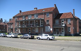
Desire Projects was a housing project located in the Ninth Ward of New Orleans, Louisiana. These projects were the largest in the nation and consisted of about 262 two-story brick buildings, containing about 1,860 units across 98.5 acres of land. The overall conditions of the projects were deplorable from the moment they were put into place in the later part of the 1950s. The projects were meant to serve the large number of underprivileged African-American residents in the New Orleans area. Soon it became a place of despair, and Desire eventually evolved into a dark no-man's land, leaving many residents infested with problems and little or no help from the government. Located in a cypress swamp and dumping ground, Desire was known as the poorest housing development in New Orleans—it was bordered by railroad tracks, the Mississippi River, the Industrial Canal and a corridor of industrial plants.

St. Bernard Projects was a housing project in the city of New Orleans. A subdistrict of the Mid-City District Area, its boundaries as defined by the New Orleans City Planning Commission were: Harrison Avenue to the north, Paris Avenue to the east, Lafreniere Street and Florida Avenue to the south and Bayou St. John to the west.
Iberville Projects was a neighborhood in the city of New Orleans and one of the low-income Housing Projects of New Orleans. The Iberville was the last of the New Deal-era public housing remaining in the city. Its boundaries were St. Louis Street, Basin Street, Iberville Street, and North Claiborne Avenue. It is located in the 6th ward of downtown New Orleans, on the former site of the Storyville district. The area has recently been redeveloped into a modernized apartment complex called the Bienville Basin Apartments.

Hollygrove is a neighborhood of the city of New Orleans, Louisiana, located in the city's 17th Ward. A subdistrict of the Uptown/Carrollton area, the boundaries as defined by the New Orleans City Planning Commission are the following: Palmetto Street to the north, Cambronne, Edinburgh, Forshey, Fig and Leonidas Streets to the east, Earhart Boulevard to the south and the Jefferson Parish boundary to the west. Conrad playground, the Cuccia-Byrnes playground and Larry Gilbert baseball stadium are located in Hollygrove. The Hollygrove Market and Farm is also located in Hollygrove. Notable people including rapper Lil Wayne have grown up in the neighborhood.

Gentilly Woods is a neighborhood of the city of New Orleans. A subdistrict of the Gentilly District Area, its boundaries as defined by the City Planning Commission are: Dreux Avenue to the north, Industrial Canal to the east, Gentilly Boulevard to the south and People's Avenue to the west.
Desire Area is a neighborhood of the city of New Orleans. A subdistrict of the Bywater District Area, its boundaries as defined by the City Planning Commission are: Gentilly Boulevard to the north; the Industrial Canal to the east; Florida Boulevard, Alvar Street, Higgins Boulevard, Piety Street, Pleasure Street, Oliver White Avenue, and Desire Street to the south; and People's Avenue to the west. It is part of the Upper 9th Ward.
Florida Area is a neighborhood of the city of New Orleans. A subdistrict of the Bywater District Area, its boundaries as defined by the City Planning Commission are: Florida Boulevard, Gallier, Law, Congress and North Dorgenois Streets to the north; Mazant Street to the east; North Galvez Street to the south; and Montegut Street, Law Street, and Almonaster Avenue to the west.
St. Claude is a neighborhood of the city of New Orleans. A subdistrict of the Bywater District Area, its boundaries as defined by the City Planning Commission are: Law, Montegut and North Galvez Streets to the north, Lesseps Street to the east, Burgundy Street, Clouet Street and St. Claude Avenue to the south and Franklin Avenue to the west.

Holy Cross is a neighborhood of the city of New Orleans. A subdistrict of the Lower Ninth Ward District Area, its boundaries as defined by the City Planning Commission are: St. Claude Avenue to the north, St. Bernard Parish to the east, the Mississippi River to the south and the Industrial Canal to the west.
The B. W. Cooper Public Housing Development, also known as The Calliope Projects, was a neighborhood of the city of New Orleans and one of the housing projects of New Orleans. This project of New Orleans gained notoriety for its extremely high violent crime rate. It was demolished in 2014 and replaced with newer, mixed-income apartment buildings.
Behrman also known as "Behrman Heights", is a community located in Algiers, New Orleans It was named after popular New Orleans mayor Martin Behrman, and is nestled south of the US Naval Support neighborhood and north of Tall Timbers/Brechtel, flanked on the west by Fischer Housing Development and Whitney, and on the east by Old Aurora.
Christopher Homes, also known as Christopher Park Homes was a scattered-site housing complex in the Algiers neighborhood, operated by HANO, with originally 250 townhouse style units which opened in 1971. It would be celebrated as the nation's first rent-to-own public housing. Since the complex first opened, disgusted homeowners have been driven away by Formosan termites and rotting wood left under the complex's flat roofs. Families also fled in the 1980s after a ceiling collapsed on a girl's head and a roof leak caused an electrical short that set a boy's bed on fire. Due to the poor living conditions, pests became a major problem for residents living in the Christopher Homes. There had been numerous reports about large rodents known as "Nutria Rats" roaming though the buildings and outside, but HANO refused to get the buildings fumigated.

