
Urban renewal is a program of land redevelopment often used to address urban decay in cities. Urban renewal involves the clearing out of blighted areas in inner cities to clear out slums and create opportunities for higher class housing, businesses, and other developments.
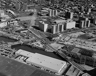
Cabrini–Green Homes was a Chicago Housing Authority (CHA) public housing project on the Near North Side of Chicago, Illinois. The Frances Cabrini Rowhouses and Extensions were south of Division Street, bordered by Larrabee Street to the west, Orleans Street to the east and Chicago Avenue to the south, with the William Green Homes to the northwest.
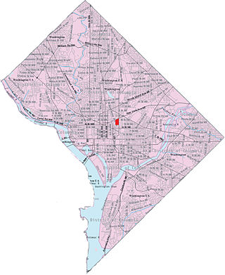
Sursum Corda is a small neighborhood located in Washington, D.C., bounded by North Capitol Street on the east, K Street NW to the south, New Jersey Avenue NW to the west, and New York Avenue NW to the north.
ABLA Homes was a Chicago Housing Authority (CHA) public housing development that comprised four separate public housing projects on the Near-West Side of Chicago, Illinois. The name "ABLA" was an acronym for the names of the four different housing developments that together constituted one large site: Addams, Brooks, Loomis, and Abbott, totaling 3,596 units. It spanned from Cabrini Street on the north end to 15th Street on the south end, and from Blue Island Avenue on the east end to Ashland Avenue on the west end. Most of the ABLA Homes have been demolished for the development of Roosevelt Square, a new mixed-income community, with the renovated Brooks Homes being the only part left. For most of its existence, the ABLAs held more than 17,000 residents, giving it the second largest population in the CHA. It was second only to the Robert Taylor Homes and Cabrini–Green in land area and had a higher occupancy than Cabrini–Green.
HOPE VI is a program of the United States Department of Housing and Urban Development. It is intended to revitalize the worst public housing projects in the United States into mixed-income developments. Its philosophy is largely based on New Urbanism and the concept of defensible space.

The Housing Authority of New Orleans is a housing authority in New Orleans, Louisiana, tasked with providing housing to low-income residents.
Desire Projects was a housing project located in the Ninth Ward of New Orleans, Louisiana. These projects were the largest in the nation and consisted of about 262 two-story brick buildings, containing about 1,860 units across 98.5 acres of land. The overall conditions of the projects were deplorable from the moment they were put into place in the later part of the 1950s. The projects were meant to serve the large number of underprivileged African American residents in the New Orleans area. Soon it became a place of despair, and Desire eventually evolved into a dark no-man's land, leaving many residents infested with problems and little or no help from the government. Located in a cypress swamp and dumping ground, Desire was known as the poorest housing development in New Orleans—it was bordered by railroad tracks, the Mississippi River, the Industrial Canal and a corridor of industrial plants.

The Melpomene Projects, officially called the Gustavo Apartments or TheGuste Homes, and colloquially The Melph, are a housing complex located in the Central City neighborhood of New Orleans.

The Lafitte Projects were one of the Housing Projects of New Orleans and were located in the 6th Ward of New Orleans Treme neighborhood. It was one of Downtown New Orleans' oldest housing developments and had many associated problems before being severely flooded and damaged during Hurricane Katrina in 2005. The project made national headlines after the gruesome murder of Thomas May who burned to death in the project in 1994. By a Department of Housing and Urban Development (HUD) decree, the projects were demolished and redeveloped as affordable, mixed-income housing. The redevelopment effort was charged with replacing every demolished unit. The large housing project was left mostly vacant following evacuations after the extensive flooding from Hurricane Katrina. Heated arguments have surrounded the demolition of the project, as some longtime residents wanted them renovated.
Iberville Projects was a neighborhood in the city of New Orleans and one of the low-income Housing Projects of New Orleans. The Iberville was the last of the New Deal-era public housing remaining in the city. Its boundaries were St. Louis Street, Basin Street, Iberville Street, and North Claiborne Avenue. It is located in the 6th ward of downtown New Orleans, on the former site of the Storyville district. The area has recently been redeveloped into a modernized apartment complex called the Bienville Basin Apartments.

The William J. Fischer Housing Development, better known as the Fischer Projects, was a housing project in Algiers, New Orleans, Louisiana, United States. It was known notoriously for a series of high-profile murders in the 1970s and 1980s. It was also the last conventional public housing development constructed in New Orleans and originally consisted of a 13-floor high-rise and fourteen 3-floor units. The area has been undergoing redevelopment since about 2004 and currently none of the original low-rise buildings remain. The development is located along Whitney Avenue in the Algiers area of the city's west bank, which is part of the 15th Ward and is named for William J. Fischer who served as chairman of HANO in the 1950s. The property is now converted to a small low-income housing development.

Lafayette Park is an neighborhood located east of Downtown Detroit. It contains a residential area of some 4,900 people and covers 0.07 sq mi.
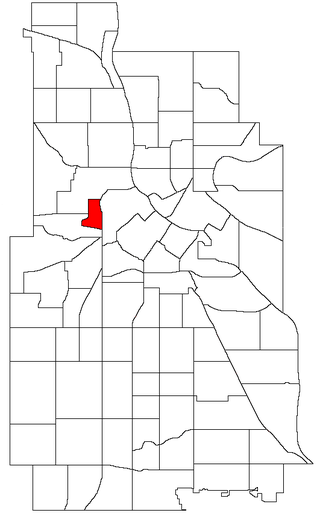
Sumner-Glenwood is a neighborhood in U.S. city of Minneapolis. It is located in the broader Near North community and the area is referred to as Heritage Park by the neighborhood association. Summer-Glenwood is roughly contained by 15 city blocks bordered to the north by 11th Avenue North, to the south by Glenwood Avenue, to the east by Interstate 94, and to the west by both Girard Terrace and Emerson Avenue North. (2)

Internally displaced persons in the United States are people from the Gulf States region in the southern United States, most notably New Orleans, Louisiana, who were forced to leave their homes because of the devastation brought on by Hurricane Katrina in 2005 and were unable to return because of a multitude of factors, and are collectively known as the Gulf Coast diaspora and by standard definition considered IDPs. At their peak, hurricane evacuee shelters housed 273,000 people and, later, FEMA trailers housed at least 114,000 households. Even a decade after Hurricane Katrina, many victims who were forced to relocate were still unable to return home.

Lower Garden District is a neighborhood of the city of New Orleans. A subdistrict of the Central City/Garden District Area, its boundaries as defined by the New Orleans City Planning Commission are: St. Charles Avenue, Felicity, Prytania, Thalia, Magazine, and Julia Streets to the north; the New Orleans Morial Convention Center, Crescent City Connection, and Mississippi River to the east; Felicity Street, Magazine Street, Constance Street, Jackson Avenue, Chippewa Street, Soraparu Street, and St. Thomas Street to the south; and 1st Street to the west.
In 1994 the Atlanta Housing Authority, encouraged by the federal HOPE VI program, embarked on a policy created for the purpose of comprehensive revitalization of severely distressed public housing developments. These distressed public housing properties were replaced by mixed-income communities.
The neighborhood of Faubourg Lafayette is a division in the city of New Orleans, Louisiana. It is also known as the 10th Ward of New Orleans, and it is one of the city's 17 wards. Faubourg Lafayette was founded with small settlements around steamboat landings in New Orleans. John Poultney acquired the property from Madame Rousseau on May 2, 1818. This was a plantation measuring about 10 arpents, near the Mississippi River waterfront. The property was bounded by the lower line of property owned by Jacques François Enoul de Livaudais. This property ran through the squares between Soraparu and First streets at Tchoupitoulas Street. St. Andrew Street bounds the property below.
The Calliope Projects, also known as B. W. Cooper Public Housing Development, was a neighborhood of the city of New Orleans and one of the housing projects of New Orleans. This project of New Orleans gained notoriety for its extremely high violent crime rate. It was demolished in 2014 and replaced with newer, mixed-income apartment buildings.
Behrman also known as "Behrman Heights," is a crime-ridden low income community located in Algiers, New Orleans It was named after popular New Orleans mayor Martin Behrman, and is nestled south of the US Naval Support neighborhood and north of Tall Timbers/Brechtel, flanked on the west by Fischer Housing Development and Whitney, and on the east by Old Aurora.

New Columbia is a housing development in the Portsmouth neighborhood of Portland, Oregon. It was previously called Columbia Villa. It is operated by the city's public housing authority, Home Forward, and is the largest public housing development in the state.


