
State Road 528 (SR 528), alternatively named the Martin Andersen Beachline Expressway, is a partially-tolled freeway in the U.S. state of Florida; it is maintained by the Florida's Turnpike Enterprise (FTE), the Central Florida Expressway Authority (CFX), and the Florida Department of Transportation (FDOT). Spanning approximately 53 miles (85 km) along a west–east axis, it connects Interstate 4 (I-4) in Orlando with I-95, Titusville, and Cape Canaveral on the Space Coast. It passes close to the tourist areas of Orlando, including SeaWorld and Universal Orlando, and serves the north entrance to Orlando International Airport. Near its east end, it passes over the Intracoastal Waterway on the Emory L. Bennett Causeway, and ends at SR A1A and SR 401 near Port Canaveral.

U.S. Route 92 or U.S. Highway 92 is a 181-mile (291 km.) U.S. Route entirely in the U.S. state of Florida. The western terminus is at US 19 Alt. and SR 687 in downtown St. Petersburg. The eastern terminus is at SR A1A in Daytona Beach.

State Road A1A (SR A1A) is a major north–south Florida State Road consisting of seven separate sections running a total of 338.752 miles (545.168 km) along the Atlantic Ocean, from Key West at the southern tip of Florida, to Fernandina Beach, just south of Georgia on Amelia Island. It is the main road through most oceanfront towns. Part of SR A1A is designated the A1A Scenic and Historic Coastal Byway, a National Scenic Byway. A portion of SR A1A that passes through Volusia County is designated the Ormond Scenic Loop and Trail, a Florida Scenic Highway. It is also called the Indian River Lagoon Scenic Highway from State Road 510 at Wabasso Beach to U.S. Route 1 in Cocoa. SR A1A is famous worldwide as a center of beach culture in the United States, a scenic coastal route through most Atlantic coastal cities and beach towns, including the unique tropical coral islands of the Florida Keys. SR A1A also serves as a major thoroughfare through Miami Beach and other south Florida coastal cities.

Florida State Road 9 (SR 9) is a state road in the U.S. state of Florida. While SR 9 is mainly used as a state designation for Interstate 95 in Florida from the Golden Glades Interchange in Miami Gardens to the Georgia border, a signed SR 9, which is locally known in the Miami area as West 27th Avenue, Unity Boulevard, and historically Grapeland Boulevard, extends 13 miles (21 km) from the Coconut Grove section of Miami to the Golden Glades Interchange. The segment of I-95 south of the Golden Glades Interchange carries the designation of State Road 9A.
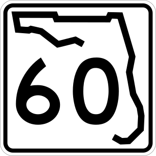
State Road 60, or Route 60 is an east–west route transversing Florida from the Gulf of Mexico to the Atlantic Ocean. The western terminus of SR 60 is at the Sunsets at Pier 60 site in Clearwater Beach. The eastern terminus is in Vero Beach near the Atlantic Coast just past State Road A1A.

Dale Mabry Highway is a north–south road in Tampa, Florida. The majority of its length consists of three lanes each direction plus a central turn-lane and often includes a right-turn lane. It begins at the MacDill Air Force Base entrance in South Tampa and ends by merging with US 41 just north of the Pasco County border. The highway carries multiple designations, carrying US 92 for an approximately five-mile (8.0 km) stretch between Hillsborough Avenue and Gandy Boulevard.
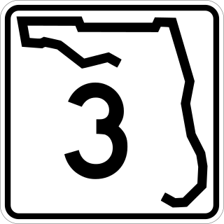
State Road 3, known locally as both North Courtenay Parkway and North Kennedy Parkway is a north–south road located entirely on Merritt Island, serving as the southern access for the Kennedy Space Center near Cape Canaveral, Florida. The shortest of the one-digit Florida State Roads, its southern terminus is an intersection with SR 520 on Merritt Island, east of Cocoa.

Dixie Highway in Palm Beach and Broward counties carries two segments of the State Road 811 designation by Florida Department of Transportation, as well as the local County Road 811 in southeast Florida. The entire road comprises a section of the Dixie Highway, a National Auto Trail which eventually became a former routing of U.S. Route 1 after the route was shifted east to Federal Highway. One segment of SR 811 is in Broward County and the other is in Palm Beach County, Florida. The segments of SR 811 are supplemented by three shorter segments of CR 811, one of which is unsigned.

State Road 934 runs for 13.1 miles (21.1 km) from State Road 826 in Medley to SR A1A in Miami Beach. It is a major east–west highway in the Miami metropolitan area.

State Road 858, known locally as Hallandale Beach Boulevard, is a 5.429-mile-long (8.737 km) divided highway in southern Broward County, Florida. Its western terminus is an intersection with U.S. Route 441 at the border between Miramar and West Park; its eastern terminus is an intersection with South Ocean Drive on the boundary between Hallandale Beach and Hollywood, just east of the Intracoastal Waterway. SR 858 is the latitudinal baseline for Hallandale Beach's street grid.

Indiantown Road is a 17-mile (27 km) east–west road connecting inner Palm Beach County, with Florida's Turnpike, Interstate 95, and U.S. Route 1 in Jupiter, Florida. The road was formerly entirely designated as State Road 706 (SR 706), but majority of it has been transferred to local jurisdiction and is signed as County Road 706.
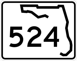
State Road 524 is a five-mile-long southwest–northeast street in Cocoa, Florida. It is signed east–west.

Sunrise Boulevard is a 15.6 miles (25.1 km) long east–west highway serving central Broward County mostly designated State Road 838. The road begins at an interchange with the Sawgrass Expressway in Sunrise and continues east to North Ocean Boulevard in Fort Lauderdale, next to Hugh Taylor Birch State Park. For 0.91 miles (1.46 km) in downtown Fort Lauderdale, SR 838 overlaps U.S. Route 1.

Interstate 95 (I-95) is the main Interstate Highway of Florida's Atlantic Coast. It begins at a partial interchange with US Highway 1 (US 1) just south of downtown Miami and heads north through Jacksonville, and to the Georgia state line at the St. Marys River near Becker. The route also passes through the cities of Fort Lauderdale, West Palm Beach, Port St. Lucie, Titusville, and Daytona Beach.
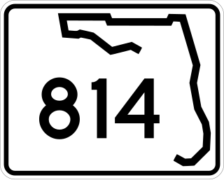
Atlantic Boulevard, consisting mostly of State Road 814, is a major commercial and commuter highway in northern Broward County, Florida. The 13-mile-long (21 km) divided highway extends from the Sawgrass Expressway in Coral Springs to State Road A1A in Pompano Beach. It serves as the latitudinal baseline for the street grid for the city of Pompano Beach. The portion of the boulevard west of U.S. Route 441 is locally maintained as County Road 814.

State Road 816, locally known as Oakland Park Boulevard is a 13.420-mile-long (21.597 km) east–west commercial and commuter road serving central Broward County, Florida, carrying the designations of State Road 816 (SR 816) and County Road 816 (CR 816). It extends from the Sawgrass Expressway east to an intersection with SR A1A in Fort Lauderdale.

The NASA Causeway, is an east–west expressway in Brevard County, Florida, containing two causeways. The first causeway connects the Florida mainland to Merritt Island and later, over the private second causeway, connects Merritt Island to Cape Canaveral. As such, the NASA Causeway is the main route connecting points of interest in Titusville, Florida to the Kennedy Space Center on Merritt Island.

U.S. Highway 1 (US 1) in Florida runs 545 miles (877 km) along the state's east coast from Key West to its crossing of the St. Marys River into Georgia north of Boulogne and south of Folkston. US 1 was designated through Florida when the U.S. Numbered Highway System was established in 1926. With the exception of Monroe County, the highway runs through the easternmost tier of counties in the state, connecting numerous towns and cities along its route, including nine county seats. The road is maintained by the Florida Department of Transportation (FDOT).
The Indian River Lagoon Scenic Highway is a 130-mile-long (210 km) scenic byway located in Florida. The highway is a collection of several roads, running north and south along either side of the Indian River Lagoon, connected by other roads running over the Lagoon.

U.S. Route 421 (US 421) is part of the United States Numbered Highway System that runs from Fort Fisher, North Carolina to Michigan City, Indiana. In the U.S. state of North Carolina, US 421 travels 328 miles (528 km) from its southern terminus at Fort Fisher to the Tennessee state line near the community of Zionville, North Carolina. US 421 traverses the state from east to west travelling from the coastal plains to Appalachian Mountains. It provides an important connection between the cities of Wilmington, Sanford, Greensboro, Winston-Salem, and Boone. Despite being signed as north–south, much of the routing of US 421 in North Carolina runs in an east–west direction, particularly between Greensboro and the Tennessee state line. Portions of US 421 have been upgraded to freeway standards including the majority of its routing between Sanford and North Wilkesboro.


