A compass is a device that shows the cardinal directions used for navigation and geographic orientation. It commonly consists of a magnetized needle or other element, such as a compass card or compass rose, which can pivot to align itself with magnetic north. Other methods may be used, including gyroscopes, magnetometers, and GPS receivers.

Flight instruments are the instruments in the cockpit of an aircraft that provide the pilot with data about the flight situation of that aircraft, such as altitude, airspeed, vertical speed, heading and much more other crucial information in flight. They improve safety by allowing the pilot to fly the aircraft in level flight, and make turns, without a reference outside the aircraft such as the horizon. Visual flight rules (VFR) require an airspeed indicator, an altimeter, and a compass or other suitable magnetic direction indicator. Instrument flight rules (IFR) additionally require a gyroscopic pitch-bank, direction and rate of turn indicator, plus a slip-skid indicator, adjustable altimeter, and a clock. Flight into instrument meteorological conditions (IMC) require radio navigation instruments for precise takeoffs and landings.

A magnetometer is a device that measures magnetic field or magnetic dipole moment. Different types of magnetometers measure the direction, strength, or relative change of a magnetic field at a particular location. A compass is one such device, one that measures the direction of an ambient magnetic field, in this case, the Earth's magnetic field. Other magnetometers measure the magnetic dipole moment of a magnetic material such as a ferromagnet, for example by recording the effect of this magnetic dipole on the induced current in a coil.
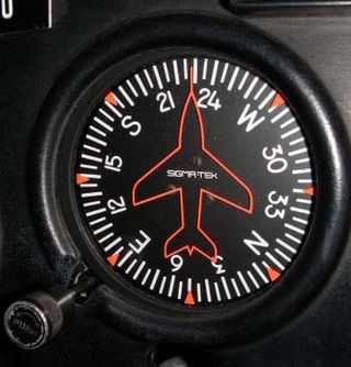
The heading indicator (HI), also known as a directional gyro (DG) or direction indicator (DI), is a flight instrument used in an aircraft to inform the pilot of the aircraft's heading.

An automatic direction finder (ADF) is a marine or aircraft radio-navigation instrument that automatically and continuously displays the relative bearing from the ship or aircraft to a suitable radio station. ADF receivers are normally tuned to aviation or marine NDBs operating in the LW band between 190 – 535 kHz. Like RDF units, most ADF receivers can also receive medium wave (AM) broadcast stations, though these are less reliable for navigational purposes.
In aviation, aircraft compass turns are turns made in an aircraft using only a magnetic compass for guidance.
Magnetic deviation is the error induced in a compass by local magnetic fields, which must be allowed for, along with magnetic declination, if accurate bearings are to be calculated.

A Brunton compass, properly known as the Brunton Pocket Transit, is a precision compass made by Brunton, Inc. of Riverton, Wyoming. The instrument was patented in 1894 by Canadian-born geologist David W. Brunton. Unlike most modern compasses, the Brunton Pocket Transit utilizes magnetic induction damping rather than fluid to damp needle oscillation. Although Brunton, Inc. makes many other types of magnetic compasses, the Brunton Pocket Transit is a specialized instrument used widely by those needing to make accurate navigational and slope-angle measurements in the field. Users are primarily geologists, but archaeologists, environmental engineers, mining engineers and surveyors also make use of the Brunton's capabilities. The United States Army has adopted the Pocket Transit as the M2 Compass for use by crew-served artillery.

Diver navigation, termed "underwater navigation" by scuba divers, is a set of techniques—including observing natural features, the use of a compass, and surface observations—that divers use to navigate underwater. Free-divers do not spend enough time underwater for navigation to be important, and surface supplied divers are limited in the distance they can travel by the length of their umbilicals and are usually directed from the surface control point. On those occasions when they need to navigate they can use the same methods used by scuba divers.

The horizontal situation indicator is an aircraft flight instrument normally mounted below the artificial horizon in place of a conventional heading indicator. It combines a heading indicator with a VHF omnidirectional range-instrument landing system (VOR-ILS) display. This reduces pilot workload by lessening the number of elements in the pilot's instrument scan to the six basic flight instruments. Among other advantages, the HSI offers freedom from the confusion of reverse sensing on an instrument landing system localizer back course approach. As long as the needle is set to the localizer front course, the instrument will indicate whether to fly left or right, in either direction of travel.

Magnetic dip, dip angle, or magnetic inclination is the angle made with the horizontal by Earth's magnetic field lines. This angle varies at different points on Earth's surface. Positive values of inclination indicate that the magnetic field of Earth is pointing downward, into Earth, at the point of measurement, and negative values indicate that it is pointing upward. The dip angle is in principle the angle made by the needle of a vertically held compass, though in practice ordinary compass needles may be weighted against dip or may be unable to move freely in the correct plane. The value can be measured more reliably with a special instrument typically known as a dip circle.

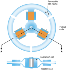
The Earth inductor compass is a compass that determines directions using the principle of electromagnetic induction, with the Earth's magnetic field acting as the induction field for an electric generator. The electrical output of the generator will vary depending on its orientation with respect to the Earth's magnetic field. This variation in the generated voltage is measured, allowing the Earth inductor compass to determine direction.

In geophysics, a magnetic anomaly is a local variation in the Earth's magnetic field resulting from variations in the chemistry or magnetism of the rocks. Mapping of variation over an area is valuable in detecting structures obscured by overlying material. The magnetic variation in successive bands of ocean floor parallel with mid-ocean ridges was important evidence for seafloor spreading, a concept central to the theory of plate tectonics.
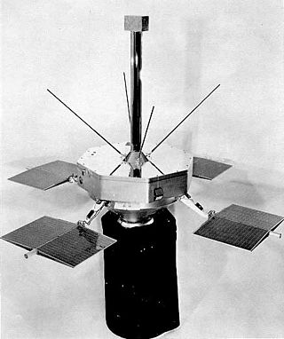
Spacecraft magnetometers are magnetometers used aboard spacecraft and satellites, mostly for scientific investigations, plus attitude sensing. Magnetometers are among the most widely used scientific instruments in exploratory and observation satellites. These instruments were instrumental in mapping the Van Allen radiation belts around Earth after its discovery by Explorer 1, and have detailed the magnetic fields of the Earth, Moon, Sun, Mars, Venus and other planets and moons. There are ongoing missions using magnetometers, including attempts to define the shape and activity of Saturn's core.

Explorer 14, also called EPE-B or Energetic Particles Explorer-B, was a NASA spacecraft instrumented to measure cosmic-ray particles, trapped particles, solar wind protons, and magnetospheric and interplanetary magnetic fields. It was the second of the S-3 series of spacecraft, which also included Explorer 12, 14, 15, and 26. It was launched on 2 October 1962, aboard a Thor-Delta launch vehicle.

Explorer 10 was a NASA satellite that investigated Earth's magnetic field and nearby plasma. Launched on 25 March 1961, it was an early mission in the Explorer program and was the first satellite to measure the "shock wave" generated by a solar flare.

Magnetometer (MAG) is an instrument suite on the Juno orbiter for planet Jupiter. The MAG instrument includes both the Fluxgate Magnetometer (FGM) and Advanced Stellar Compass (ASC) instruments. There two sets of MAG instrument suites, and they are both positioned on the far end of three solar panel array booms. Each MAG instrument suite observes the same swath of Jupiter, and by having two sets of instruments, determining what signal is from the planet and what is from spacecraft is supported. Avoiding signals from the spacecraft is another reason MAG is placed at the end of the solar panel boom, about 10 m and 12 m away from the central body of the Juno spacecraft.

Explorer 12, also called EPE-A or Energetic Particles Explorer-A and as S3), was a NASA satellite built to measure the solar wind, cosmic rays, and the Earth's magnetic field. It was the first of the S-3 series of spacecraft, which also included Explorer 12, 14, 15, and 26. It was launched on 16 August 1961, aboard a Thor-Delta launch vehicle. It ceased transmitting on 6 December 1961 due to power failure.
Explorer 15, also called EPE-C or Energetic Particles Explorer-C, was a NASA satellite launched as part of the Explorer program. Explorer 15 was launched on 27 October 1962, at Cape Canaveral Air Force Station, Florida, United States, with a Thor-Delta A.

Explorer 45 was a NASA satellite launched as part of Explorer program. Explorer 45 was the only one to be released from the program Small Scientific Satellite.