
Goshen is a city in and the county seat of Elkhart County, Indiana, United States. It is the smaller of the two principal cities of the Elkhart–Goshen Metropolitan Statistical Area, which in turn is part of the South Bend–Elkhart–Mishawaka Combined Statistical Area. It is located in the northern part of Indiana near the Michigan border, in a region known as Michiana. Goshen is located 10 miles southeast of Elkhart, 25 miles southeast of South Bend, 120 miles east of Chicago, and 150 miles north of Indianapolis. The population was 34,517 at the 2020 census.
LaGrange County is a county located in the U.S. state of Indiana. As of 2020, the population was 40,446. The county seat is LaGrange, Indiana.

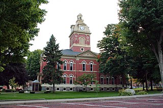
Elkhart County is a county located in the U.S. state of Indiana. As of 2020, the county's population was 207,047. The county seat is Goshen. Elkhart County is part of the Elkhart-Goshen Metropolitan Statistical Area, which in turn is part of the South Bend-Elkhart-Mishawaka Combined Statistical Area. It is also considered part of the broader region of Northern Indiana known as Michiana, and is 20 miles (32 km) east of South Bend, Indiana, 110 miles (180 km) east of Chicago, Illinois, and 150 miles (240 km) north of Indianapolis, Indiana. The area is referred to by locals as the recreation vehicle (RV) capital of the world and is known for its sizable Amish and Old Order Mennonite population.

Elkhart is a city in Elkhart County, Indiana, United States. The city is located 15 miles (24 km) east of South Bend, Indiana, 110 miles (180 km) east of Chicago, Illinois, and 150 miles (240 km) north of Indianapolis, Indiana. Elkhart has the larger population of the two principal cities of the Elkhart-Goshen Metropolitan Statistical Area, which in turn is part of the South Bend-Elkhart-Mishawaka Combined Statistical Area, in a region commonly known as Michiana. The population was 53,923 at the 2020 census. Despite the shared name and being the most populous city in the county, it is not the county seat of Elkhart County; that position is held by the city of Goshen, located about 10 miles (16 km) southeast of Elkhart.

Nappanee is a city in Elkhart and Kosciusko counties in the U.S. state of Indiana. The population was 6,648 as of the 2010 U.S. Census and had grown to 6,913 by the 2020 U.S. Census. The name Nappanee is thought to mean "flour" in the Algonquian language.

New Paris is a census-designated place (CDP) in Elkhart County, Indiana, United States. The population was 1,494 at the 2010 census.

Northern Indiana is a region of the U.S. State of Indiana, including 26 counties which border the states of Illinois, Michigan, and Ohio. Northern Indiana is also considered part of the Great Lakes Megalopolis. The area is generally classified into other sub-regions; Northwest Indiana is closely tied with Chicago economically, culturally, and politically and is part of the Chicago metropolitan area. The north central region centers on South Bend metropolitan area, with economic connections to southwest Michigan. Northeast Indiana is centered on the Fort Wayne metropolitan area.

Baugo Township is one of sixteen townships in Elkhart County, Indiana. As of the 2010 census, its population was 9,431.

Cleveland Township is one of sixteen townships in Elkhart County, Indiana. As of the 2010 census, its population was 11,158.

Clinton Township is one of sixteen townships in Elkhart County, Indiana. As of the 2020 census, its population was 4,870, up from 4,624 at the previous census.

Concord Township is one of sixteen townships in Elkhart County, Indiana. As of the 2000 census, its population was 54,167.

Harrison Township is one of sixteen townships in Elkhart County, Indiana. As of the 2010 census, its population was 4,435.

Locke Township is one of sixteen townships in Elkhart County, Indiana. As of the 2010 census, its population was 3,913.

Union Township is one of sixteen townships in Elkhart County, Indiana. As of the 2010 census, its population was 6,134.

Benton is an unincorporated community in Benton Township, Elkhart County, Indiana.
Southwest is an unincorporated community in Harrison Township, Elkhart County, Indiana.
Waterford Mills is an unincorporated community in Elkhart Township, Elkhart County, Indiana.
Rainsboro is an unincorporated community in Paint Township, Highland County, Ohio, United States.
Foraker is an unincorporated community in Hardin County, in the U.S. state of Ohio.


