Dunlap, Indiana

Last updated

Dunlap, Indiana
Elkhart County Indiana Incorporated and Unincorporated areas Dunlap Highlighted 1819072.svg
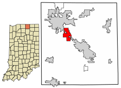
Location of Dunlap in Elkhart County, Indiana.
Coordinates: 41°37′40″N85°55′12″W / 41.62778°N 85.92000°W / 41.62778; -85.92000
Country United States
State Indiana
County Elkhart
Area
[1]
  Total4.93 sq mi (12.76 km2)
  Land4.92 sq mi (12.74 km2)
  Water0.01 sq mi (0.03 km2)
Elevation
[2]
778 ft (237 m)
Population
 (2020)
  Total6,442
  Density1,310.15/sq mi (505.84/km2)
Time zone UTC-5 (Eastern (EST))
  Summer (DST) UTC-4 (EDT)
ZIP code
46517, 46516, 46526
Area code 574
FIPS code 18-19072 [3]
GNIS feature ID2392982 [2]

Dunlap is a census-designated place (CDP) in Elkhart County, Indiana, United States. The population was 6,235 at the 2010 census. [4] Once a small farming community, by the 1980s it had become a suburb of Elkhart and Goshen, Indiana. Most of the town was destroyed by two violent F4 tornadoes during the Palm Sunday Tornado Outbreak on April 11, 1965.

Contents

History

A post office was established at Dunlap in 1886, and remained in operation until it was discontinued in 1902. [5]

Geography

According to the United States Census Bureau, the CDP has a total area of 4.9 square miles (12.7 km2), of which 0.20% is water. [6]

Demographics

Historical population
CensusPop.Note
2020 6,442
U.S. Decennial Census [7]

As of the census [3] of 2000, there were 5,887 people, 2,087 households, and 1,657 families residing in the CDP. The population density was 1,390.4 inhabitants per square mile (536.8/km2). There were 2,147 housing units at an average density of 507.1 per square mile (195.8/km2). The racial makeup of the CDP was 91.69% White, 2.87% African American, 0.17% Native American, 0.93% Asian, 0.10% Pacific Islander, 3.04% from other races, and 1.19% from two or more races. Hispanic or Latino of any race were 4.65% of the population.

There were 2,087 households, out of which 37.2% had children under the age of 18 living with them, 66.3% were married couples living together, 9.5% had a female householder with no husband present, and 20.6% were non-families. 16.6% of all households were made up of individuals, and 7.2% had someone living alone who was 65 years of age or older. The average household size was 2.82 and the average family size was 3.16.

In the CDP, the population was spread out, with 28.8% under the age of 18, 7.3% from 18 to 24, 28.1% from 25 to 44, 25.6% from 45 to 64, and 10.1% who were 65 years of age or older. The median age was 37 years. For every 100 females, there were 96.7 males. For every 100 females age 18 and over, there were 91.9 males.

The median income for a household in the CDP was $52,083, and the median income for a family was $55,522. Males had a median income of $40,802 versus $25,500 for females. The per capita income for the CDP was $19,733. About 5.0% of families and 6.1% of the population were below the poverty line, including 8.1% of those under age 18 and 6.4% of those age 65 or over.

Education

Dunlap is served by Concord Community Schools, including Concord High School. [8] [9]

The community has a public library, a branch of the Elkhart Public Library. [10]

Transportation

The Interurban Trolley Concord and Elkhart-Goshen routes run through Dunlap, connecting the town to the nearby cities Elkhart and Goshen.

Related Research Articles

<span class="mw-page-title-main">Goshen, Indiana</span> City in Indiana, United States

Goshen is a city in and the county seat of Elkhart County, Indiana, United States. It is the smaller of the two principal cities of the Elkhart–Goshen Metropolitan Statistical Area, which in turn is part of the South Bend–Elkhart–Mishawaka Combined Statistical Area. It is located in the northern part of Indiana near the Michigan border, in a region known as Michiana. Goshen is located 10 miles southeast of Elkhart, 25 miles southeast of South Bend, 120 miles east of Chicago, and 150 miles north of Indianapolis. The population was 34,517 at the 2020 census.

<span class="mw-page-title-main">Elkhart County, Indiana</span> County in Indiana, United States

Elkhart County is a county located in the U.S. state of Indiana. As of 2020, the county's population was 207,047. The county seat is Goshen. Elkhart County is part of the Elkhart-Goshen Metropolitan Statistical Area, which in turn is part of the South Bend-Elkhart-Mishawaka Combined Statistical Area. It is also considered part of the broader region of Northern Indiana known as Michiana, and is 20 miles (32 km) east of South Bend, Indiana, 110 miles (180 km) east of Chicago, Illinois, and 150 miles (240 km) north of Indianapolis, Indiana. The area is referred to by locals as the recreation vehicle (RV) capital of the world and is known for its sizable Amish and Old Order Mennonite population.

<span class="mw-page-title-main">Concord, Alabama</span> CDP in Alabama, United States

Concord is a census-designated place in Jefferson County, Alabama, United States. At the 2010 census the population was 1,837, up from 1,809 in 2000. It is northwest from the Birmingham suburb of Hueytown.

<span class="mw-page-title-main">McDonald Chapel, Alabama</span> CDP in Alabama, United States

McDonald Chapel is a census-designated place in Jefferson County, Alabama, United States. It is northeast of the Birmingham suburb of Pleasant Grove. At the 2020 census, the population was 739. Large portions of this area were damaged by violent tornadoes in 1956, 1998, and 2011. The 1998 tornado was rated F5 on the Fujita scale.

<span class="mw-page-title-main">Rock Creek, Alabama</span> CDP in Alabama, United States

Rock Creek is a census-designated place in Jefferson County, Alabama, United States. Its location is northwest of Hueytown. At the 2020 census, the population was 1,471. This area was damaged by an F5 tornado on April 8, 1998. An EF2 tornado struck northwest from here on January 23, 2012.

<span class="mw-page-title-main">Goshen, California</span> Census-designated place in California, United States

Goshen is a census-designated place (CDP) near Visalia, in Tulare County, California, United States. The population was at 5,387 in the 2020 census, up from the 3,006 in the 2010 census. Until the twentieth century, Goshen was an island in a marsh at the edge of Tulare Lake, formerly the largest freshwater lake west of the Great Lakes until drained.

<span class="mw-page-title-main">Henryville, Indiana</span> Census-designated place in Indiana, United States

Henryville is a census-designated place (CDP) in Monroe Township, Clark County, in the U.S. state of Indiana. The population was 1,905 at the 2010 census.

<span class="mw-page-title-main">Memphis, Indiana</span> CDP in Indiana, United States

Memphis is a census-designated place (CDP) in Clark County, Indiana, United States. The population was 695 at the 2010 census.

<span class="mw-page-title-main">Bristol, Indiana</span> Town in Indiana, United States

Bristol is a town in Washington Township, Elkhart County, Indiana, United States. The population was 1,602 at the 2010 census.

<span class="mw-page-title-main">New Paris, Indiana</span> Census-designated place in Indiana, United States

New Paris is a census-designated place (CDP) in Elkhart County, Indiana, United States. The population was 1,494 at the 2010 census.

<span class="mw-page-title-main">Simonton Lake, Indiana</span> Census-designated place in Indiana, United States

Simonton Lake is a census-designated place (CDP) in Elkhart County, Indiana, United States. The population was 4,678 at the 2010 census.

<span class="mw-page-title-main">Wakarusa, Indiana</span> Town in Indiana, United States

Wakarusa is a town in Harrison and Olive townships in Elkhart County, Indiana, United States. The population was 1,758 at the 2010 census.

<span class="mw-page-title-main">Koontz Lake, Indiana</span> Census-designated place in Indiana, United States

Koontz Lake is an unincorporated community and census-designated place (CDP) in Starke and Marshall counties, in the U.S. state of Indiana. The population was 1,667 at the 2020 census.

<span class="mw-page-title-main">Lake Village, Indiana</span> CDP in Newton County, Indiana, United States

Lake Village is a census-designated place (CDP) in Lake Township, Newton County, in the U.S. state of Indiana. The population was 765 at the 2010 census.

<span class="mw-page-title-main">Granger, Indiana</span> Census-designated place in Indiana, United States

Granger is a census-designated place (CDP) in Clay and Harris townships, St. Joseph County, in the U.S. state of Indiana. The population was 30,465 at the 2010 census. Penn-Harris-Madison School Corporation and the South Bend Community School Corporation maintain the public schools in the area. Granger is part of the South Bend–Mishawaka metropolitan area as well as the larger Michiana region.

<span class="mw-page-title-main">West Concord, Massachusetts</span> Census-designated place in Massachusetts, United States

West Concord is an unincorporated village and census-designated place (CDP) in the town of Concord in Middlesex County, Massachusetts, United States. The population was 6,320 at the 2020 census.

<span class="mw-page-title-main">Concord, Missouri</span> CDP in Missouri, United States

Concord is a census-designated place (CDP) in St. Louis County, Missouri, United States. The population was 16,421 at the 2010 census. It should not be confused with Concord Township; which the CDP shares much land with, but these areas' boundaries are not identical.

West Goshen was a census-designated place (CDP) in West Goshen Township, Chester County, Pennsylvania, United States. The population was 8,472 at the 2000 census. The CDP was not delineated for the 2010 census.

<span class="mw-page-title-main">Elberta, Utah</span> CDP in Utah, United States

Elberta is a census-designated place (CDP) in Utah County, Utah, United States. It is part of the Provo–Orem Metropolitan Statistical Area. The population was 256 at the 2010 census. It was founded as Mt. Nebo. After the water failed in 1901, most of the early settlers moved away. It was purchased by Matthew B. Whitney, a native of New York, on November 7, 1907, and he renamed it "Elberta" after the peach cultivar.

<span class="mw-page-title-main">Hawk Springs, Wyoming</span> CDP in Wyoming, United States

Hawk Springs is a census-designated place (CDP) in Goshen County, Wyoming, United States. The population was 45 at the 2010 census.

References

  1. "2020 U.S. Gazetteer Files". United States Census Bureau. Retrieved March 16, 2022.
  2. 1 2 U.S. Geological Survey Geographic Names Information System: Dunlap, Indiana
  3. 1 2 "U.S. Census website". United States Census Bureau . Retrieved January 31, 2008.
  4. "Profile of General Population and Housing Characteristics: 2010 Demographic Profile Data (DP-1): Dunlap CDP, Indiana". United States Census Bureau . Retrieved July 12, 2012.
  5. "Elkhart County". Jim Forte Postal History. Retrieved September 4, 2014.
  6. "Geographic Identifiers: 2010 Demographic Profile Data (G001): Dunlap CDP, Indiana". United States Census Bureau . Retrieved July 12, 2012.
  7. "Census of Population and Housing". Census.gov. Retrieved June 4, 2016.
  8. "2010 CENSUS - CENSUS BLOCK MAP: Dunlap CDP, IN." U.S. Census Bureau. Retrieved on December 6, 2016.
  9. "SCHOOL DISTRICT REFERENCE MAP (2010 CENSUS): Elkhart County, IN." U.S. Census Bureau. Retrieved on December 6, 2016.
  10. "Library Branches". Elkhart Public Library. Archived from the original on March 8, 2018. Retrieved March 7, 2018.