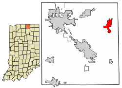
Middlebury, Indiana | |
---|---|
Coordinates: 41°40′10″N85°42′29″W / 41.66944°N 85.70806°W | |
Country | United States |
State | Indiana |
County | Elkhart |
Township | Middlebury |
Area | |
• Total | 4.35 sq mi (11.27 km2) |
• Land | 4.33 sq mi (11.22 km2) |
• Water | 0.02 sq mi (0.04 km2) |
Elevation | 876 ft (267 m) |
Population (2020) | |
• Total | 3,466 |
• Density | 799.91/sq mi (308.87/km2) |
Time zone | UTC-5 (Eastern (EST)) |
• Summer (DST) | UTC-4 (EDT) |
ZIP code | 46540 |
Area code | 574 |
FIPS code | 18-48924 [3] |
GNIS feature ID | 2396758 [2] |
Website | http://www.middleburyin.org/publishsite/index.cfm |
Middlebury is a town in Middlebury Township, Elkhart County, Indiana, United States. It is located approximately 35 miles east of South Bend, 130 miles east of Chicago, Illinois and 165 miles north of Indianapolis. Middlebury is nestled in Northern Indiana's Amish country. As of the 2010 census, the town population was 3,420.
Middlebury sits on the banks of the Little Elkhart River in the middle of a mix of rolling hills and rural farm land.
According to the 2010 census, Middlebury has a total area of 3.78 square miles (9.79 km2), of which 3.76 square miles (9.74 km2) (or 99.47%) is land and 0.02 square miles (0.05 km2) (or 0.53%) is water. [4]
Before the Europeans came to the region, the Miami and later the Potawatomi ruled the area. That changed in 1832, when the first settlers came from Middlebury, Vermont. They chose this specific area because the rolling hills reminded them of Vermont. [5] Later, in 1841, the first Amish families came from Somerset County, Pennsylvania and settled in the countryside surrounding the town. Middlebury Township was organized in 1834 and the town of Middlebury was finally incorporated in 1868. [5]
In 1888, the railroad came to Middlebury and began to diversify the town's economy to include manufacturing as well as farming. [5]
Census | Pop. | Note | %± |
---|---|---|---|
1880 | 502 | — | |
1890 | 542 | 8.0% | |
1900 | 572 | 5.5% | |
1910 | 600 | 4.9% | |
1920 | 599 | −0.2% | |
1930 | 656 | 9.5% | |
1940 | 722 | 10.1% | |
1950 | 839 | 16.2% | |
1960 | 917 | 9.3% | |
1970 | 1,055 | 15.0% | |
1980 | 1,665 | 57.8% | |
1990 | 2,004 | 20.4% | |
2000 | 2,956 | 47.5% | |
2010 | 3,420 | 15.7% | |
2020 | 3,466 | 1.3% | |
U.S. Decennial Census [6] |
As of the census, [7] [8] [9] of 2010, there were 3,420 people, 1,263 households, and 822 families residing in the town. The population density was 911.1 inhabitants per square mile (351.8/km2). There were 1,341 housing units at an average density of 357.8 per square mile (138.1/km2). The racial makeup of the town was 95.6% White, 0.6% African American, 0.1% Native American, 1.2% Asian, 0.0% Pacific Islander, 1.1% from other races, and 1.5% from two or more races. Hispanic or Latino of any race were 3.2% of the population.
There were 1,263 households, of which 35.9% had children under the age of 18 living with them, 61.3% were married couples living together, 9.9% had a female householder with no husband present, and 24.4% were non-families. 20.7% of all households were made up of individuals, and 11.5% had someone living alone who was 65 years of age or older. The average household size was 2.70 and the average family size was 3.11.
The population was spread out, with 29.0% under the age of 18, 8.0% from 18 to 24, 24.8% from 25 to 44, 24.8% from 45 to 64, and 13.4% who were 65 years of age or older. The median age was 36.7 years. For every 100 females, there were 94.6 males. For every 100 females age 18 and over, there were 91.6 males.
The median income for a household in the town was $54,714, and the median income for a family was $68,273. Males had a median income of $48,894 versus $34,688 for females. The per capita income for the town was $25,825. 2.5% of families and 4.0% of the population were living below the poverty line, including 6.3% under eighteens and 7.1% of those over 65.
The Middlebury Community School system attracts many families to the area. The grade alignment is K-3, 4-5, 6-8, and 9-12. Northridge opened in 1969 and replaced the aging Middlebury and Jefferson Township High Schools. The high school moved into a new building for the 2008-09 school year; the old high school became Northridge Middle School and Heritage Middle School became an intermediate school. [10]
Jefferson Elementary was torn down and replaced in 1998 shortly after Orchard View had opened in 1995.
School | Type | School Corporation | Nickname |
---|---|---|---|
Heritage | Intermediate | Middlebury | Knights |
Jefferson | Elementary | Middlebury | Tigers |
Middlebury | Elementary | Middlebury | Middies |
Northridge | High | Middlebury | Raiders |
Northridge | Middle | Middlebury | Raiders |
Orchard View | Elementary | Middlebury | Eagles |
York | Elementary | Middlebury | Mustangs |
The town has a free lending library, the Middlebury Community Public Library. [11]
Middlebury's economy is based on farming, manufacturing, and tourism. A $95,000 earmark was included in the federal FY2009 Omnibus Appropriations Bill to fund "Middlebury Economic Development, IN for development of a comprehensive plan for economic development that takes into account infrastructure needs, land use planning, and downtown redevelopment while balancing the needs of the large Amish population with that of the broader community." [12]
Four major manufacturers of recreational vehicles, Grand Design, Winnebago, Jayco and Coachmen RV, have production facilities in Middlebury. Culver Duck Farms, the 2nd largest white pekin duck producer in the United States is located in Middlebury, shipping 70,000+ ducks a week worldwide. Syndicate Systems' largest facility, for the manufacture of retail shelving is also located in town. Middlebury is home to bus manufacturer ARBOC Specialty Vehicles. The Meijer Central Kitchen produces deli salads, deli sandwiches, cookies, and sub buns for the entire Meijer department store chain and is also a distribution center.
Much of Middlebury's tourism revolves around Das Dutchman Essenhaus. The Amish-themed restaurant, inn, conference center, and shops serve over 750,000 people every year. [13] The facility also has a wholesale food operation on site which ships various home-made products. [13]
The town is also home to Krider World's Fair Garden and the Pumpkinvine Nature Trail. [14]
Goshen is a city in and the county seat of Elkhart County, Indiana, United States. It is the smaller of the two principal cities of the Elkhart–Goshen Metropolitan Statistical Area, which in turn is part of the South Bend–Elkhart–Mishawaka Combined Statistical Area. It is located in the northern part of Indiana near the Michigan border, in a region known as Michiana. Goshen is located 10 miles southeast of Elkhart, 25 miles southeast of South Bend, 120 miles east of Chicago, and 150 miles north of Indianapolis. The population of Goshen was 34,517 at the 2020 census.
LaGrange County is a county located in the U.S. state of Indiana. As of 2020, the population was 40,446. The county seat is LaGrange, Indiana. The county is located in the Northern Indiana region known as Michiana and is about 55 miles (89 km) east of South Bend, 105 miles (169 km) west of Toledo, Ohio, and 175 miles (282 km) northeast of Indianapolis. The area is well known for its large Amish population. For that reason, the county teams up with neighboring Elkhart County to promote tourism by referring to the area as Northern Indiana Amish Country. About half of LaGrange County is Amish, and it is home to the third-largest Amish community in the United States, which belongs to the Elkhart-LaGrange Amish affiliation.
Elkhart County is a county located in the U.S. state of Indiana. As of 2020, the county's population was 207,047. The county seat is Goshen. Elkhart County is part of the Elkhart-Goshen Metropolitan Statistical Area, which in turn is part of the South Bend-Elkhart-Mishawaka Combined Statistical Area. It is also considered part of the broader region of Northern Indiana known as Michiana, and is 20 miles (32 km) east of South Bend, Indiana, 110 miles (180 km) east of Chicago, Illinois, and 150 miles (240 km) north of Indianapolis, Indiana. The area is referred to by locals as the recreation vehicle (RV) capital of the world and is known for its sizable Amish and Old Order Mennonite population.
Monroe is a town in Washington and Monroe townships, Adams County, Indiana, United States. The population of the town was 945 residents at the 2019 census. Adams Central Community Schools is located in Monroe.
Grabill is a town in Cedar Creek Township, Allen County, Indiana, United States. The population was 1,053 at the 2010 census. Today it is known for the presence of antique stores and Amish farms. An incorporated town, Grabill has two community parks within the corporate limits.
Montgomery is a town in Barr Township, Daviess County, Indiana, United States. The population was 792 at the 2020 census.
Bristol is a town in Washington Township, Elkhart County, Indiana, United States. The population was 1,602 at the 2010 census.
Dunlap is a census-designated place (CDP) in Elkhart County, Indiana, United States. The population was 6,235 at the 2010 census. Once a small farming community, by the 1980s it had become a suburb of Elkhart and Goshen, Indiana. Most of the town was destroyed by two violent F4 tornadoes during the Palm Sunday Tornado Outbreak on April 11, 1965.
Nappanee is a city in Elkhart and Kosciusko counties in the U.S. state of Indiana. The population was 6,648 as of the 2010 U.S. Census and had grown to 6,913 by the 2020 U.S. Census. The name Nappanee is thought to mean "flour" in the Algonquian language.
New Paris is a census-designated place (CDP) in Elkhart County, Indiana, United States. The population was 1,494 at the 2010 census.
Simonton Lake is a census-designated place (CDP) in Elkhart County, Indiana, United States. The population was 4,678 at the 2010 census.
Wakarusa is a town in Harrison and Olive townships in Elkhart County, Indiana, United States. The population was 1,758 at the 2010 census.
Shipshewana is a town in Newbury Township, LaGrange County, Indiana, United States. The population was 658 at the 2010 census. It is the location of the Menno-Hof Amish & Mennonite Museum, which showcases the history of the Amish and Mennonite peoples.
New Richmond is a town in Coal Creek Township, Montgomery County, in the U.S. state of Indiana. The population was 309 at the 2020 census.
Osceola is a town in Penn Township, St. Joseph County, in the U.S. state of Indiana. The population was 2,463 at the 2010 Census. It is part of the South Bend–Mishawaka, IN-MI, Metropolitan Statistical Area.
Elkhart is a city in Polk County, Iowa, United States. The population was 882 at the time of the 2020 census. It is part of the Des Moines–West Des Moines Metropolitan Statistical Area.
Smyrna is a town in Aroostook County, Maine, United States. The population was 439 at the 2020 census.
Brady Township is a township in Clearfield County, Pennsylvania, United States. The population was 1,941 at the 2020 census.
Smicksburg is a borough in Indiana County, Pennsylvania, United States. The population was 57 at the 2020 census, and it is one of the smallest incorporated boroughs in Pennsylvania. It was founded by the Reverend J. George Schmick.
Millersburg is a town in Clinton and Benton townships, Elkhart County, Indiana, United States. The population was 903 at the 2010 census.
{{cite web}}
: CS1 maint: archived copy as title (link)