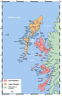
The Hebrides comprise a widespread and diverse archipelago off the west coast of mainland Scotland. There are two main groups: the Inner and Outer Hebrides.

New Caledonia is a special collectivity of France, currently governed under the Nouméa Accord, located in the southwest Pacific Ocean, to the south of Vanuatu, about 1,210 km (750 mi) east of Australia and 20,000 km (12,000 mi) from Metropolitan France. The archipelago, part of the Melanesia subregion, includes the main island of Grande Terre, the Loyalty Islands, the Chesterfield Islands, the Belep archipelago, the Isle of Pines, and a few remote islets. The Chesterfield Islands are in the Coral Sea. French people, and especially locals, refer to Grande Terre as Le Caillou.
Vanuatu, officially the Republic of Vanuatu, is a Pacific island country located in the South Pacific Ocean. The archipelago, which is of volcanic origin, is 1,750 kilometres (1,090 mi) east of northern Australia, 540 kilometres (340 mi) northeast of New Caledonia, east of New Guinea, southeast of the Solomon Islands, and west of Fiji.
The history of Vanuatu begins obscurely. The commonly held theory of Vanuatu's prehistory from archaeological evidence supports that peoples speaking Austronesian languages first came to the islands some 3,300 years ago. Pottery fragments have been found dating back to 1300 BC. What little is known of the pre-European contact history of Vanuatu has been gleaned from oral histories and legends. One important early king was Roy Mata, who united several tribes, and was buried in a large mound with several retainers.

The Outer Hebrides, also known as the Western Isles, Innse Gall or the Long Isle/Long Island, is an island chain off the west coast of mainland Scotland. The islands are geographically coextensive with Comhairle nan Eilean Siar, one of the 32 unitary council areas of Scotland. They form part of the archipelago of the Hebrides, separated from the Scottish mainland and from the Inner Hebrides by the waters of the Minch, the Little Minch, and the Sea of the Hebrides. Scottish Gaelic is the predominant spoken language, although in a few areas English speakers form a majority.

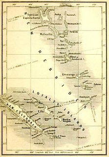
New Hebrides, officially the New Hebrides Condominium and named for the Hebrides Scottish archipelago, was the colonial name for the island group in the South Pacific Ocean that is now Vanuatu. Native people had inhabited the islands for three thousand years before the first Europeans arrived in 1606 from a Spanish expedition led by Portuguese navigator Pedro Fernandes de Queirós. The islands were colonised by both the British and French in the 18th century, shortly after Captain James Cook visited.

John Frum is a figure associated with cargo cults on the island of Tanna in Vanuatu. He is often depicted as an American World War II serviceman who will bring wealth and prosperity to the people if they follow him. Quoting David Attenborough's report of an encounter: "'E look like you. 'E got white face. 'E tall man. 'E live 'long South America."
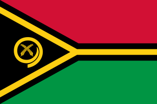
The flag of Vanuatu was adopted on 18 February 1980.

Moruroa, also historically known as Aopuni, is an atoll which forms part of the Tuamotu Archipelago in French Polynesia in the southern Pacific Ocean. It is located about 1,250 kilometres (780 mi) southeast of Tahiti. Administratively Moruroa Atoll is part of the commune of Tureia, which includes the atolls of Tureia, Fangataufa, Tematangi and Vanavana. France undertook nuclear weapon tests between 1966 and 1996 at Moruroa and Fangataufa, causing international protests, notably in 1974 and 1995. The number of tests performed has been variously reported as 175 and 181.

The first mail service to the Gilbert and Ellice Islands was ad hoc, depending on which ships were calling at the various islands. A regular service began in 1911; Edward VII postage stamps of Fiji were overprinted GILBERT & ELLICE / PROTECTORATE and put on sale on 1 January of that year, followed in March by a set of four stamps depicting a Pandanus tree, inscribed GILBERT & ELLICE ISLANDS / PROTECTORATE.
The Vanuatu national football team is the national team of Vanuatu and is controlled by the Vanuatu Football Federation.

This is a survey of the postage stamps and postal history of Vanuatu, formerly known as the New Hebrides, an island group in the South Pacific. Between 1906 and 1980, the islands were an Anglo-French Condominium.

The British Western Pacific Territories (BWPT) was the name of a colonial entity, created in 1877, for the administration, under a single representative of the British Crown, styled High Commissioner for the Western Pacific, of a series of Pacific islands in and around Oceania. Except for Fiji and the Solomon Islands, most of these colonial possessions were relatively minor.
Burns Philp was once a major Australian shipping line and merchant that operated in the South Pacific. In later years the company was a major player in the food manufacturing business. Since its delisting from the Australian Stock Exchange in December 2006 and the subsequent sale of its assets, the company has mainly become a cashed up shell company. It is wholly owned by Graeme Hart's Rank Group.

USS Adhara (AK-71) was a Crater-class cargo ship in the service of the US Navy in the Pacific theater in World War II. Named after the star Adhara in the constellation Canis Major, it was the only ship of the Navy to bear this name.
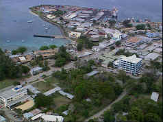
Honiara is the capital city of Solomon Islands, situated on the northwestern coast of Guadalcanal. As of 2017, it had a population of 84,520 people. The city is served by Honiara International Airport and the seaport of Point Cruz, and lies along the Kukum Highway.

General elections were held for the first time in the New Hebrides on 10 November 1975. The result was a victory for the New Hebrides National Party, which won 17 seats in the new Representative Assembly.
James Douglas Gordon was a Scottish-Canadian missionary to the New Hebrides. Gordon was born in Alberton, Prince Edward Island, the younger brother of George N. Gordon. James followed his brother to Erromango after the latter was martyred in 1861.
Rugby union at the Pacific Games has been contested since 1963 when included as one of ten sports at the first games held in Suva, Fiji. Rugby sevens is the form of rugby now played at the Pacific Games, with men's and women's tournaments included in the current schedule. The women's competition was added for the first time at the 2011 Pacific Games held in Nouméa.

The 1971 South Pacific Games, held at Papeete in Tahiti from 25 August to 5 September 1971, was the fourth edition of the South Pacific Games.
